Rowe, Virginia | |
|---|---|
Unincorporated community | |
 Rowe, Virginia  Rowe, Virginia | |
| Coordinates: 37°08′10″N82°01′57″W / 37.13611°N 82.03250°W | |
| Country | United States |
| State | Virginia |
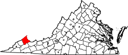
| County | Buchanan |
| Elevation | 1,709 ft (521 m) |
| Time zone | UTC-5 (Eastern (EST)) |
| • Summer (DST) | UTC-4 (EDT) |
| ZIP code | 24646 |
| Area code | 276 |
| GNIS feature ID | 1499998 [1] |
Rowe is an unincorporated community in Buchanan County, Virginia, United States. Rowe is located on State Route 624, six miles south of Oakwood. Rowe has a post office with ZIP code 24646, which opened on January 25, 1939. [2] [3]
It was likely named for John S. Rowe, a pioneer settler. [4]