Vansant, Virginia

Last updated
Vansant, Virginia
VAMap-doton-Vansant.PNG
Location of Vansant, Virginia
Coordinates: 37°13′36″N82°5′56″W / 37.22667°N 82.09889°W / 37.22667; -82.09889 Coordinates: 37°13′36″N82°5′56″W / 37.22667°N 82.09889°W / 37.22667; -82.09889
CountryUnited States
State Virginia
County Buchanan
Area
  Total7.9 sq mi (20.3 km2)
  Land7.9 sq mi (20.3 km2)
  Water0.0 sq mi (0.0 km2)
Elevation
1,129 ft (344 m)
Population
 (2010)
  Total470
  Density59/sq mi (23/km2)
Time zone UTC−5 (Eastern (EST))
  Summer (DST) UTC−4 (EDT)
ZIP code
24656
Area code(s) 276
FIPS code 51-80608 [1]
GNIS feature ID1500252 [2]

Vansant is a census-designated place (CDP) in Buchanan County, Virginia, United States. The population was 470 at the 2010 census. Vansant is located just south of the town of Grundy.

Contents

Geography

Vansant is located at 37°13′36″N82°5′56″W / 37.22667°N 82.09889°W / 37.22667; -82.09889 (37.226587, 82.098787). [3] The town is located at the intersection of U.S. Route 460 and State Route 83 directly on the banks of the Levisa Fork. Vansant is located in the coalfields of the Appalachian Mountains.

According to the United States Census Bureau, the CDP has a total area of 7.8 square miles (20.3 km2), all of it land.

Demographics

At the 2000 census, [1] there were 989 people, 436 households and 309 families residing in the CDP. The population density was 125.9 per square mile (48.6/km2). There were 500 housing units at an average density of 63.7/sq mi (24.6/km2). The racial makeup of the CDP was 98.89% White, 0.61% Asian, and 0.51% from two or more races. Hispanic or Latino of any race were 0.30% of the population.

There were 436 households, of which 24.3% had children under the age of 18 living with them, 54.8% were married couples living together, 12.4% had a female householder with no husband present, and 29.1% were non-families. 25.9% of all households were made up of individuals, and 11.0% had someone living alone who was 65 years of age or older. The average household size was 2.27 and the average family size was 2.73.

Age distribution was 19.0% under the age of 18, 6.6% from 18 to 24, 27.8% from 25 to 44, 31.9% from 45 to 64, and 14.8% who were 65 years of age or older. The median age was 43 years. For every 100 females, there were 89.1 males. For every 100 females age 18 and over, there were 85.8 males.

The median household income was $26,250, and the median family income was $30,104. Males had a median income of $28,068 versus $20,714 for females. The per capita income for the CDP was $13,743. About 14.7% of families and 17.1% of the population were below the poverty line, including 30.0% of those under age 18 and 10.6% of those age 65 or over.

Related Research Articles

Blue Ridge, Alabama Census-designated place in Alabama, United States

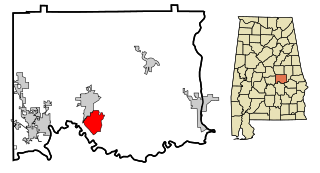
Blue Ridge is an unincorporated community and census-designated place (CDP) in Elmore County, Alabama, United States. At the 2010 census the population was 1,341. It is part of the Montgomery Metropolitan Statistical Area.

South Highpoint, Florida Census-designated place in Florida, United States

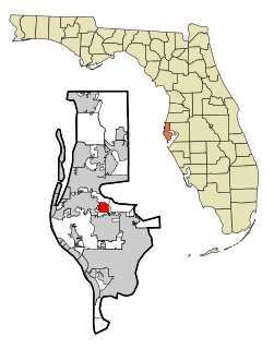
South Highpoint is a census-designated place (CDP) in Pinellas County, Florida, United States. The population was 5,195 at the 2010 census.

Frankfort Square, Illinois Census-designated place in Illinois, United States

Frankfort Square is a census-designated place (CDP) in Will County, Illinois, United States. The population was 9,276 at the 2010 census.

McRoberts, Kentucky Census-designated place in Kentucky, United States

McRoberts is an unincorporated community and census-designated place (CDP) in Letcher County, Kentucky, United States. The population was 784 at the 2010 United States Census, down from 921 at the 2000 census. McRoberts is in the Eastern Kentucky Coalfield region.

Phelps, Kentucky CDP in Kentucky, United States

Phelps is a census-designated place (CDP) in Pike County, Kentucky, United States. The population was 1,053 at the 2000 census.

Lake Shore, Maryland Census-designated place in Maryland, United States

Lake Shore is a census-designated place and unincorporated community in Anne Arundel County, Maryland, United States, located east of Pasadena. The population of Lake Shore was 19,477 at the 2010 census.

Huntingtown, Maryland Census-designated place in Maryland, United States

Huntingtown, established 1683, is a census-designated place (CDP) in Calvert County, Maryland, United States. The population was 3,311 at the 2010 census, up from 2,436 in 2000. Many large estate homes have recently been built in small developments off routes 2/4. It has a public high school called Huntingtown High. The Calverton School is located just south of the town center. State-operated commuter buses and private vanpools carry residents to Washington.

Norton Center, Massachusetts Census-designated place in Massachusetts, United States

Norton Center is a census-designated place (CDP) in the town of Norton in Bristol County, Massachusetts, United States. The population was 2,671 at the 2010 census.

West End, New York Census-designated place in New York, United States

West End is an unincorporated suburban community in Otsego County, New York, United States. The population was 1,940 at the 2010 census.

Mission, Oregon Census-designated place in Oregon, United States

Mission is an unincorporated community in Umatilla County, Oregon, United States. For statistical purposes, the United States Census Bureau has defined Mission as a census-designated place (CDP). The census definition of the area may not precisely correspond to local understanding of the area with the same name. The population was 1,019 at the 2000 census.

Branchdale, Pennsylvania CDP in Pennsylvania, United States

Branchdale is a census-designated place (CDP) in Schuylkill County, Pennsylvania, United States. The population was 436 at the 2000 census.

Davidsville is a census-designated place (CDP) in Somerset County, Pennsylvania, United States. The population was 1,119 at the 2000 census. It is part of the Johnstown, Pennsylvania, Metropolitan Statistical Area. Davidsville is part of the municipality of Conemaugh Township, Somerset County, Pennsylvania, as are the nearby towns of Jerome, Thomas Mills, Tire Hill, Seanor, Hyasota, and part of Holsopple. Davidsville is Area code: 814 Exchange: 479; ZIP Code: 15928.

Inman Mills, South Carolina CDP in South Carolina, United States

Inman Mills is a census-designated place (CDP) in Spartanburg County, South Carolina, United States. The population was 1,050 at the 2010 census.

West Lake Sammamish, Bellevue, Washington Neighborhood in King, Washington, United States

West Lake Sammamish was a census-designated place (CDP) in King County, Washington, United States. The population was 5,937 at the 2000 census. The census area was annexed by Bellevue in 2001.

Holden, West Virginia CDP in West Virginia, United States

Holden is a census-designated place (CDP) in Logan County, West Virginia, United States. The population was 876 at the 2010 census.

Mount Gay-Shamrock, West Virginia CDP in West Virginia, United States

Mount Gay-Shamrock is a census-designated place (CDP) in Logan County, West Virginia, United States. The population was 1,779 at the 2010 census.

Chattaroy, West Virginia Census-designated place in West Virginia, United States

Chattaroy is a census-designated place (CDP) in Mingo County, West Virginia, United States. The population was 756 at the 2010 census.

Red Jacket, West Virginia Census-designated place in West Virginia, United States

Red Jacket is a census-designated place (CDP) in Mingo County, West Virginia, in the United States. The population was 581 at the 2010 census. The community was named for Red Jacket, a Seneca chief.

Daniels, West Virginia Census-designated place in West Virginia, United States

Daniels is a census-designated place (CDP) in Raleigh County, West Virginia, United States. The population was 1,881 at the 2010 census.

Reserve, Wisconsin CDP in Wisconsin, United States

Reserve is a census-designated place (CDP) in the Town of Couderay, Sawyer County, Wisconsin, United States. The population was 429 at the 2010 census.

References

  1. 1 2 "U.S. Census website". United States Census Bureau . Retrieved 2008-01-31.
  2. "US Board on Geographic Names". United States Geological Survey. 2007-10-25. Retrieved 2008-01-31.
  3. "US Gazetteer files: 2010, 2000, and 1990". United States Census Bureau. 2011-02-12. Retrieved 2011-04-23.