Turleytown, Virginia

Last updated
Turleytown
USA Virginia location map.svg
Red pog.svg
Turleytown
Location in Virginia
Usa edcp location map.svg
Red pog.svg
Turleytown
Turleytown (the United States)
Coordinates: 38°36′50.43″N78°52′16.09″W / 38.6140083°N 78.8711361°W / 38.6140083; -78.8711361 Coordinates: 38°36′50.43″N78°52′16.09″W / 38.6140083°N 78.8711361°W / 38.6140083; -78.8711361
CountryFlag of the United States.svg  United States
State Flag of Virginia.svg  Virginia
County Rockingham County
Elevation
387 m (1,270 ft)
GNIS feature ID 1493724

Turleytown is an unincorporated community located in Rockingham County, in the U.S. state of Virginia.

Contents

Geography

It is located west of Broadway, along State Route 613. [1]

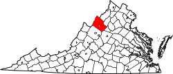
Rockingham County VA location map.svg
Red pog.svg
Turleytown
Location of Turleytown within the Rockingham County

History

Turleytown is believed to be named after Giles Turley who visited it in 1804. [2]

Related Research Articles

West Virginia Route 161

West Virginia Route 161 is a north–south state highway located entirely within McDowell County, West Virginia. The southern terminus of the route is at West Virginia Route 16 in Bishop less than 900 feet (270 m) from the Virginia state line. The northern terminus is at U.S. Route 52 in Elkhorn.

Route 311 (Virginia–West Virginia)

Virginia State Route 311 and West Virginia Route 311 are adjoining state highways in the U.S. states of Virginia and West Virginia. The two state highways together run 58.7 miles (94.5 km) from U.S. Route 11 in Salem, Virginia north to Interstate 64 and U.S. Route 60 near White Sulphur Springs, West Virginia. The two Virginia portions of Route 311 are maintained by the Virginia Department of Transportation, with the exception of the city-maintained portion within Salem. The West Virginia segments are maintained by the West Virginia Division of Highways.

Virginia State Route 179

State Route 179 is a primary state highway in the U.S. state of Virginia. The state highway runs 2.94 miles (4.73 km) from SR 1023 in Onancock east to U.S. Route 13 Business in Onley in central Accomack County.

Doveville is an unincorporated community in Fairfax County, in the U.S. state of Virginia. It lies along Virginia State Highway 236, west of Annandale, east of the independent city of Fairfax and southwest of Merrifield. Immediately to the south is Rutherford and immediately to the north is Mantua. Numerous parks are located nearby, including Long Branch Stream Valley Park to the south, Daniels Run Park to the west and Woodburn Road Park and Accotink Stream Valley Park to the northeast.

Bergton, formerly Dovesville, is an unincorporated community located in Rockingham County, in the U.S. state of Virginia. It is located in George Washington National Forest, northwest of Timberville and adjacent to Criders near the state border with West Virginia.

Montezuma is an unincorporated community located in Rockingham County, in the U.S. state of Virginia.

Criders is an unincorporated community located in Rockingham County, in the U.S. state of Virginia. It is located in George Washington National Forest, west of Bergton near the state border with West Virginia.

Edom is an unincorporated community located in Rockingham County, in the U.S. state of Virginia. It is located along State Route 42 at the crossroads with State Route 721, north of Harrisonburg and southeast of Singers Glen. Linville Creek flows through the village.

Hinton is an unincorporated community located in Rockingham County, in the U.S. state of Virginia. It is located northwest of Harrisonburg along U.S. Route 33 and Route 752 near the edge of George Washington National Forest.

Mauzy is an unincorporated community located in Rockingham County, in the U.S. state of Virginia. It is located south of Timberville, just north of Lacey Spring along Route 259, just off Interstate 81.

Lilly is an unincorporated community located in Rockingham County, in the U.S. state of Virginia. It is located west of Harrisonburg, Virginia along Route 613, northeast of Clover Hill, near the edge of the George Washington National Forest.

Mount Clinton is an unincorporated community located in Rockingham County, in the U.S. state of Virginia. It is located northeast of Clover Hill. There are several Mennonite churches in the vicinity, one of which is located along the access road to the west. It is two miles north of Hinton.

Rawley Springs, Virginia Unincorporated community in Virginia, United States

Rawley Springs is an unincorporated community located in Rockingham County, in the U.S. state of Virginia.

Stemphleytown is an unincorporated community located in Rockingham County, in the U.S. state of Virginia.

Yankeetown is an unincorporated community located in Rockingham County, in the U.S. state of Virginia.
Several special routes of U.S. Route 19 exist. In order from south to north they are as follows.

Virginia State Route 102 and West Virginia Route 102 are adjoining state highways in the U.S. states of Virginia and West Virginia. The two state highways together run 11.4 miles (18.3 km) from Center Street in Pocahontas, Virginia east to the Virginia – West Virginia state line between the twin cities of Bluefield, Virginia and Bluefield, West Virginia. Most of Route 102 consists of three sections in Virginia maintained by the Virginia Department of Transportation (VDOT); the two intervening sections in West Virginia are maintained by the West Virginia Division of Highways. In addition to connecting Pocahontas with the two Bluefields, the state highway passes through Nemours, West Virginia and Falls Mills, Virginia and provides access to Bluefield College.

West Augusta, Virginia Unincorporated community in Virginia, United States

West Augusta is an unincorporated community in Augusta County, Virginia, United States. West Augusta is located at the intersection of U.S. Route 250 and Virginia State Route 629. The source of the Calfpasture River, which flows through West Augusta, is located near the community to the north.

Jahnke is a neighborhood in Richmond, Virginia located in the Southside region of the city. The neighborhood lies within the city limits. The zip code for the neighborhood is 23225. Jahnke is named after Jahnke Road which is the main road through the neighborhood. The heart of Jahnke is at the intersection of Jahnke Road and German School Road.

References

  1. Google Maps (Map). Google.
  2. The Lincolns in Virginia . Printed for the author by the McClure Printing Co. 1946. p.  247 . Retrieved 26 January 2011.