Edom, Virginia

Last updated

Edom
USA Virginia location map.svg
Red pog.svg
Edom
Location in Virginia
Usa edcp location map.svg
Red pog.svg
Edom
Edom (the United States)
Coordinates: 38°31′32″N78°51′40″W / 38.52556°N 78.86111°W / 38.52556; -78.86111
CountryFlag of the United States.svg  United States
State Virginia
County Rockingham County

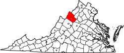
Edom is an unincorporated community located in Rockingham County, in the U.S. state of Virginia. It is located along State Route 42 at the crossroads with State Route 721, north of Harrisonburg and southeast of Singers Glen. [1] Linville Creek flows through the village.

Near Edom on January 14, 1794, Dr. Jesse Bennett performed the first Caesarian section and oophorectomy in the United States, operating on his wife to give birth to their daughter. A historical marker was erected by the state of Virginia in 1983 commemorating the event. [2]

Baxter House, John K. Beery Farm, and Edom Store and Post Office are listed on the National Register of Historic Places. [3]

Related Research Articles

<span class="mw-page-title-main">U.S. Route 66</span> Former US Highway between Chicago and Santa Monica

U.S. Route 66 or U.S. Highway 66 was one of the original highways in the United States Numbered Highway System. It was established on November 11, 1926, with road signs erected the following year. The highway, which became one of the most famous roads in the United States, ran from Chicago, Illinois, through Missouri, Kansas, Oklahoma, Texas, New Mexico, and Arizona before terminating in Santa Monica in Los Angeles County, California, covering a total of 2,448 miles (3,940 km).

<span class="mw-page-title-main">Gordonsville, Virginia</span> Town in Virginia, United States

Gordonsville is a town in Orange County in the Commonwealth of Virginia in the United States. Located about 19 miles northeast of Charlottesville and 65 miles northwest of Richmond, the population was 1,496 at the 2010 census.

<span class="mw-page-title-main">Jefferson Davis Highway</span> Historic long-distance highway in the United States

The Jefferson Davis Highway, also known as the Jefferson Davis Memorial Highway, was a transcontinental highway in the United States in the 1910s and 1920s that began in Arlington, Virginia, and extended south and west to San Diego, California; it was named for Jefferson Davis, President of the Confederate States, United States senator, and Secretary of War. Because of unintended conflict between the National Auto Trail movement and the federal government, it is unclear whether it ever really existed in the complete form that its United Daughters of the Confederacy (UDC) founders originally intended.

<span class="mw-page-title-main">Washington and Old Dominion Railroad</span> Defunct railroad in Virginia, United States

The Washington and Old Dominion Railroad was an intrastate short-line railroad located in Northern Virginia, United States. The railroad was a successor to the bankrupt Washington and Old Dominion Railway and to several earlier railroads, the first of which began operating in 1859. The railroad closed in 1968.

<span class="mw-page-title-main">National Register of Historic Places listings in Michigan</span>

This is a list of properties on the National Register of Historic Places in the U.S. state of Michigan.
     This National Park Service list is complete through NPS recent listings posted February 16, 2024.

<span class="mw-page-title-main">National Register of Historic Places listings in Virginia</span>

Buildings, sites, districts, and objects in Virginia listed on the National Register of Historic Places:

<span class="mw-page-title-main">Hermitage Road Historic District</span> Historic district in Virginia, United States

Hermitage Road Historic District (HRHD) is a Northside neighborhood in the independent city of Richmond, Virginia. The district is a Richmond Old and Historic District, as well as being listed on the Virginia Landmarks Register and the National Register of Historic Places.

The Great Wagon Road was an improved trail through the Great Appalachian Valley from Pennsylvania to North Carolina, and from there to Georgia in colonial America.

<span class="mw-page-title-main">Great Falls and Old Dominion Railroad</span> Former trolley line in Virginia

The Great Falls and Old Dominion Railroad (GF&OD) was an interurban trolley line that ran in Northern Virginia during the early 20th century.

<span class="mw-page-title-main">Morven, Virginia</span> Unincorporated community in Virginia, United States

Morven is a rural unincorporated community in northwestern Amelia County just south of the Appomattox River in the U.S. state of Virginia. It is located in Leigh District at the intersection of SR 681 and SR 616, northwest of Flat Creek. The name sometimes appears as "Moryen", probably a misspelling. A portion of the segment of U.S. Bicycle Route 1 that runs southwest from Richmond follows SR 616 through Morven.

<span class="mw-page-title-main">Boundary markers of the original District of Columbia</span> Markers that marked the District of Columbias original boundary

The boundary markers of the original District of Columbia are the 40 milestones that marked the four lines forming the boundaries between the states of Maryland and Virginia and the square of 100 square miles (259 km2) of federal territory that became the District of Columbia in 1801. Working under the supervision of three commissioners that President George Washington had appointed in 1790 in accordance with the federal Residence Act, a surveying team led by Major Andrew Ellicott placed these markers in 1791 and 1792. Among Ellicott's assistants were his brothers Joseph and Benjamin Ellicott, Isaac Roberdeau, George Fenwick, Isaac Briggs and an African American astronomer, Benjamin Banneker.

<span class="mw-page-title-main">Stafford, Virginia</span> Census-designated place in Virginia, United States

Stafford, also known as Stafford Courthouse, is a census-designated place in and the county seat of Stafford County, Virginia, United States. The population was 5,370 as of the 2020 census. It lies 10 miles (16 km) north of Fredericksburg, approximately 40 miles (64 km) south of Washington, D.C., and about 60 miles (97 km) north of Richmond, the state capital. Marine Corps Base Quantico is located north of the community. Stafford Courthouse is located at the intersections of U.S. Route 1 and Courthouse Road.

<span class="mw-page-title-main">Catawba, Virginia</span> Community in Virginia, United States

Catawba is an unincorporated community in the northern section of Roanoke County, Virginia, United States. Catawba occupies the Catawba Valley bound on the south by the north slope of Catawba Mountain and on the north by several mountains which form the border between Roanoke County and Craig County. The primary road through Catawba is State Route 311. Catawba has a post office with the zip code of 24070.

<span class="mw-page-title-main">Abingdon (plantation)</span> Plantation site in Virginia, United States of America

Abingdon was an 18th- and 19th-century plantation owned by the prominent Alexander, Custis, Stuart, and Hunter families and worked at times by slaves. The plantation's site is now located in Arlington County in the U.S. state of Virginia.

<span class="mw-page-title-main">National Register of Historic Places listings in Lee County, Virginia</span>

This is a list of the National Register of Historic Places listings in Lee County, Virginia.

The Mountain Parkway Byway and Mountain Parkway Backway are two routes in northern Webster County, West Virginia. The Byway is a state-designated scenic byway which follows West Virginia Route 20 for 9.8 miles (15.8 km), traversing the headwaters of several mountain streams including the Right Fork Little Kanawha River, Jerry Run, and the Left and Laurel Forks of Holly River. The Backway explores backroads in the same area, is 32 miles (51 km) long, and follows stretches of the Right Fork Little Kanawha River and Left Fork Holly River for portions of its route.

Dr. Jesse Bennett was the first American physician to perform a successful Caesarean section, which he performed on his own wife at the birth of their only child on January 14, 1794.

Deatonville is a rural unincorporated community in the western part of Amelia County in the U.S. state of Virginia. It is located in Leigh District along SR 616 at its junctions with SR 617. Deatonville straddles the boundary between ZIP codes 23083 (Jetersville) and 23966 (Rice). One segment of U.S. Bicycle Route 1 runs southwest from Richmond; this segment follows the entire length of SR 616 through Amelia County and passes through Deatonville.

<span class="mw-page-title-main">Capon Lake Whipple Truss Bridge</span> Bridge in West Virginia

The Capon Lake Whipple Truss Bridge, formerly known as South Branch Bridge or Romney Bridge, is a historic Whipple truss bridge in Capon Lake, West Virginia. It is located off Carpers Pike and crosses the Cacapon River. The bridge formerly carried Capon Springs Road over the river, connecting Capon Springs and Capon Lake.

<span class="mw-page-title-main">Morgan Morgan Monument</span> United States historic place

The Morgan Morgan Monument, also known as Morgan Park, is a 1.05-acre (0.4 ha) roadside park in the unincorporated town of Bunker Hill in Berkeley County, West Virginia. It is located along Winchester Avenue and Mill Creek. The park features a granite monument that was erected in 1924 to memorialize Morgan Morgan (1688–1766), an American pioneer of Welsh descent, who was among the earliest European persons to settle permanently within the present-day boundaries of West Virginia.

References

  1. Google Maps (Map). Google.
  2. "Dr. Jessee Bennett—1769–1842 A-59 – Marker History". January 14, 1794. Archived from the original on April 19, 2017. Retrieved April 18, 2017.
  3. "National Register Information System". National Register of Historic Places . National Park Service. July 9, 2010.