Pleasant Valley, Rockingham County, Virginia

Last updated
Pleasant Valley, Virginia
Unincorporated community
USA Virginia location map.svg
Red pog.svg
Pleasant Valley, Virginia
Usa edcp location map.svg
Red pog.svg
Pleasant Valley, Virginia
Coordinates: 38°23′05″N78°53′50″W / 38.38472°N 78.89722°W / 38.38472; -78.89722 Coordinates: 38°23′05″N78°53′50″W / 38.38472°N 78.89722°W / 38.38472; -78.89722
Country United States
State Virginia
County Rockingham
Elevation
1,250 ft (380 m)
Time zone UTC-5 (Eastern (EST))
  Summer (DST) UTC-4 (EDT)
GNIS feature ID1493437 [1]

Pleasant Valley is an unincorporated community in Rockingham County, Virginia, United States.

Geography

Pleasant Valley is located 4.7 miles (7.6 km) south-southeast of Harrisonburg, Virginia. [2]

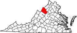
Rockingham County VA location map.svg
Red pog.svg
Pleasant Valley
Location of Pleasant Valley within the Rockingham County

Related Research Articles

Rockingham County, Virginia County in Virginia, United States

Rockingham County is a county located in the U.S. state of Virginia. As of the 2020 census, the population was 83,757. Its county seat is the independent city of Harrisonburg.

Highland County, Virginia County in Virginia, United States

Highland County is a county located in the Commonwealth of Virginia. As of the 2020 census, the population was 2,232. Its county seat is Monterey. Known as "Virginia's Switzerland" or "Virginia's Little Switzerland", Highland County is the least populous jurisdiction in Virginia, including counties and independent cities. Highland lays claim to being one of the least populous counties and one of the highest average elevations east of the Mississippi River.

Clark County, South Dakota County in South Dakota, United States

Clark County is a county in the U.S. state of South Dakota. As of the 2020 census, the population was 3,837. Its county seat is Clark. The county was created in 1873 and organized in 1881. It was named for Newton Clark, a Dakota Territory legislator in 1873.

Aurora County, South Dakota County in South Dakota, United States

Aurora County is a county in the U.S. state of South Dakota. As of the 2020 census, the population was 2,747. The county was created in 1879, and was organized in 1881.

Ross County, Ohio County in Ohio, United States

Ross County is a county in the Appalachian region of the U.S. state of Ohio. As of the 2020 United States Census, the population was 77,093. Its county seat is Chillicothe, the first and third capital of Ohio. Established on August 20, 1798, the county is named for Federalist Senator James Ross of Pennsylvania. Ross County comprises the Chillicothe, OH Micropolitan Statistical Area, which is also included in the Columbus-Marion-Zanesville, OH Combined Statistical Area.

Daniels County, Montana County in Montana, United States

Daniels County is a county located in the U.S. state of Montana. As of the 2020 census, the population was 1,661. Its county seat is Scobey.

Elkton, Virginia Town in Virginia, United States

Elkton is an incorporated town in Rockingham County, Virginia, United States. It is included in the Harrisonburg Metropolitan Statistical Area. The population was 2,762 at the 2010 census. Elkton was named for the Elk Run stream.

Moorefield, West Virginia Town in West Virginia, United States

Moorefield is a town and the county seat of Hardy County, West Virginia, United States. It is located at the confluence of the South Branch Potomac River and the South Fork South Branch Potomac River. Moorefield was originally chartered in 1777; it was named for Conrad Moore, who owned the land upon which the town was laid out. The population was 2,544 at the 2010 census.

Point Pleasant, West Virginia City in West Virginia, United States

Point Pleasant is a city in and the county seat of Mason County, West Virginia, United States, at the confluence of the Ohio and Kanawha Rivers. The population was 4,350 at the 2010 census. It is the principal city of the Point Pleasant, WV-OH Micropolitan Statistical Area.

New Hampshire Route 38 is an 8.7-mile-long (14.0 km) north–south state highway in extreme southern New Hampshire. It is the main road connecting Pelham with Salem.

U.S. Route 33 in Virginia Section of interstate highway in Virginia

U.S. Route 33 is a part of the U.S. Highway System that runs from Elkhart, Indiana to Richmond, Virginia. In Virginia, the U.S. Highway runs 135.60 miles (218.23 km) from the West Virginia state line near Rawley Springs east to its eastern terminus at SR 33 in Richmond. US 33 is the primary east–west highway of Rockingham County, which lies in the Shenandoah Valley. The highway connects the independent city of Harrisonburg, the town of Elkton, and an entrance to Shenandoah National Park. East of the Blue Ridge Mountains, US 33 connects the Piedmont communities of Stanardsville, Gordonsville, and Louisa. The U.S. Highway is a major suburban and urban route in the Richmond metropolitan area. Within Richmond, US 33 runs concurrently with US 250. SR 33 continues from US 33's eastern terminus as a state-numbered extension of the U.S. Highway that connects Richmond with Virginia's Middle Peninsula.

Interstate 74 (I-74) is a partially completed part of the Interstate Highway System that will eventually run from Davenport, Iowa, to Myrtle Beach, South Carolina. In the US state of North Carolina, I-74 currently exists in three distinct segments; from I-77 at the Virginia state line to U.S. Highway 52 (US 52) near Mount Airy, from I-40 in Winston-Salem to US 220 near Ellerbe, and from US 74 and US 74 Business near Maxton to US 74/North Carolina Highway 41 (NC 41) near Lumberton. I-74 has an extensive concurrency with I-73 from Randleman to Ellerbe in the Piedmont. When completed, I-74 will link the cities of Mount Airy, Winston-Salem, High Point, Rockingham, Laurinburg, and Lumberton.

Virginia State Route 253 State highway in Virginia, United States

State Route 253 is a primary state highway in the U.S. state of Virginia. Known as Port Republic Road, the state highway runs 12.18 miles (19.60 km) from U.S. Route 11 in Harrisonburg east to US 340 near Port Republic. SR 253 is a northwest–southeast highway that connects Harrisonburg with Cross Keys and Port Republic in southeastern Rockingham County. The state highway also provides access to portions of James Madison University on either side of Interstate 81 (I-81). SR 253 is maintained by the Virginia Department of Transportation except for the portion in the independent city of Harrisonburg, which is municipally maintained.

Virginia State Route 256

State Route 256 is a primary state highway in the U.S. state of Virginia. Known for most of its length as Weyers Cave Road, the state highway runs 6.78 miles (10.91 km) from U.S. Route 11 near Weyers Cave east to US 340 in Grottoes. SR 256 connects Interstate 81 (I-81) with Weyers Cave in northern Augusta County and Grottoes, which is home to Grand Caverns, in southeastern Rockingham County.

McGaheysville, Virginia Unincorporated community in Virginia, United States

McGaheysville is an unincorporated community located in Rockingham County, in the U.S. state of Virginia. It is located along U.S. Route 33 between Penn Laird and Elkton, and sits at the base of the Massanutten.

U.S. Route 1 (US 1) is a north–south United States highway which runs along the Eastern Coast of the United States between Key West, Florida and the United States–Canada border near Fort Kent, Maine. In North Carolina, US 1 runs for 174.1 miles (280.2 km) across the central region of the state. The highway enters North Carolina from South Carolina, southwest of Rockingham. US 1 runs northeast, passing through or closely bypassing Southern Pines and Sanford in the Sandhills region. It next passes through Cary, the state capital of Raleigh, and Wake Forest. The highway continues north to Henderson, before leaving the state at the Virginia state line, near Wise. The route is mostly a multi-lane divided arterial road, with several freeway segments. It serves as a strategic highway, connecting the North Carolina Sandhills and Research Triangle regions northwards to the Southside Virginia region.

Several special routes of U.S. Route 220 exist. In order from south to north they are as follows.

Cootes Store, Virginia Unincorporated community in Virginia, United States

Cootes Store is an unincorporated community in Rockingham County, Virginia, United States. Located in the Shenandoah Valley, it is situated north of Harrisonburg, south of Bergton, and west of Timberville. The border with West Virginia is nearby, as is the edge of George Washington National Forest. Cootes Store is within a gorge where the North Fork Shenandoah River breaks, at the crossroads of Route 613 and Route 259.

Linville, Virginia Census-designated place in Virginia, United States

Linville is a Census-designated place located in Rockingham County, in the U.S. state of Virginia. It is located 6 miles north of Harrisonburg, Virginia. It is for the first time listed as CDP for the United States Census 2020. It contains the Linville United Church of Christ.

Piedmont is an unincorporated community in Augusta County, Virginia, United States. Piedmont is located 10.4 miles (16.7 km) northeast of Staunton, Virginia and 10.1 miles (16.3 km) north-northwest of Waynesboro, Virginia. During the American Civil War, the Battle of Piedmont between Union forces under Maj. Gen. David Hunter and Confederate forces under William E. Jones was fought on June 5, 1864 just north of Piedmont. During the battle, Jones was killed and Hunter's forces captured nearly 1,000 Confederate prisoners. The Confederate defeat near Piedmont allowed Hunter to easily occupy Staunton the next day, and threatened the Confederacy's security in the Shenandoah Valley as well as on other fronts, since it necessitated the need to detach Early's Second Corps from the main body of the Army of Northern Virginia near Petersburg, Virginia.

References

  1. "Pleasant Valley". Geographic Names Information System . United States Geological Survey . Retrieved August 1, 2013.
  2. Google (August 1, 2013). "Pleasant Valley, Rockingham County, Virginia" (Map). Google Maps . Google. Retrieved August 1, 2013.