Bergton, Virginia

Last updated

Bergton
USA Virginia location map.svg
Red pog.svg
Bergton
Location in Virginia
Usa edcp location map.svg
Red pog.svg
Bergton
Bergton (the United States)
Coordinates: 38°45′52″N78°56′21″W / 38.76444°N 78.93917°W / 38.76444; -78.93917
CountryFlag of the United States.svg  United States
State Virginia
County Rockingham County
Elevation
430 m (1,410 ft)

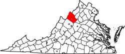
Bergton, formerly Dovesville, is an unincorporated community located in Rockingham County, in the U.S. state of Virginia. It is located in George Washington National Forest, northwest of Timberville and adjacent to Criders near the state border with West Virginia. [1] Bergton is probably best known for its annual community fair.

History

In 1936, the village along with Cootes Store was affected by the Great Flood. The flood washed away many barns, cottages and other features in the area. [2] Bergton was originally known as Dovesville for the large number of Dove families in the region. A post office mandate changed the name to avoid confusion with the town of Covesville. In 1987 the Bergton Elementary School was closed due to dwindling enrollment.

Related Research Articles

<span class="mw-page-title-main">Buena Vista, Virginia</span> Independent city in Virginia, United States

Buena Vista is an independent city located in the Blue Ridge Mountains region of Virginia in the United States. As of the 2020 census, the population was 6,641. The Bureau of Economic Analysis combines the independent cities of Buena Vista and Lexington, along with surrounding Rockbridge County, for statistical purposes.

<span class="mw-page-title-main">Glacier County, Montana</span> County in Montana, United States

Glacier County is located in the U.S. state of Montana. As of the 2020 census, the population was 13,778. The county is located in northwestern Montana between the Great Plains and the Rocky Mountains, known to the Blackfeet as the "Backbone of the World". The county is geographically and culturally diverse and includes the Blackfeet Indian Reservation, Glacier National Park, and Lewis and Clark National Forest. The county is bordered by 75 miles of international boundary with two ports of entry open year-round and one seasonal international border crossing into Alberta, Canada.

<span class="mw-page-title-main">Glasgow, Virginia</span> Town in Virginia, United States

Glasgow is a town in Rockbridge County, Virginia, United States, at the confluence of the James and Maury Rivers. The population was 1,133 at the 2010 census.

<span class="mw-page-title-main">Mount Coot-tha, Queensland</span> Suburb of Brisbane, Queensland, Australia

Mount Coot-tha is a mountain and a suburb of the City of Brisbane, Queensland, Australia. In the 2016 census, there were no residents in the suburb. Visible from much of the city, Mount Coot-tha is a popular bushland tourist destination including the Mount Coot-tha Lookout, Brisbane Botanic Gardens and Sir Thomas Brisbane Planetarium, as well as a mountain drive, bike trails, parks including a waterfall, and television and radio towers.

<span class="mw-page-title-main">Virginia State Route 259</span>

State Route 259 is a primary state highway in the U.S. state of Virginia. The state highway runs a total of 26.80 miles (43.13 km) in two sections. The southern section, in northern Rockingham County, has a length of 21.81 miles (35.10 km) from Interstate 81 (I-81) and U.S. Route 11 at Mauzy through Broadway to the West Virginia state line into Mathias. The northern section, in western Frederick County, covers 4.99 miles (8.03 km) from the West Virginia state line north to US 50 at Gore. The two sections of SR 259 are joined by West Virginia Route 259.

Tabb is an unincorporated community in York County, Virginia, United States, on the Virginia Peninsula. Major roads include U.S. Route 17 and State Route 134.

<span class="mw-page-title-main">Hightown, Virginia</span> Unincorporated community in Virginia, United States

Hightown is an unincorporated community at the crossroads of U.S. Route 250 and Secondary State Route 640 in Highland County, Virginia, United States. Hightown is located approximately 3 miles (4.8 km) northwest of Monterey, Virginia. The community lies on the division of the James River and Potomac River watersheds, with the main source of the South Branch Potomac River to the north of Hightown along State Route 640 and the source of the Jackson River, a tributary of the James, south of U.S. Route 250 west of Hightown. The roof of a barn owned by Jacob Hevener located near Hightown is said to have divided the two watersheds, with rain falling on one side of the roof flowing to the James and on the other to the Potomac. The community was originally known as Heveners Store.

<span class="mw-page-title-main">Blue Grass, Virginia</span> Unincorporated community in Virginia, United States

Blue Grass is an unincorporated community on VA 642 at its junction with VA 640 in Highland County, Virginia, United States. Blue Grass lies along the South Branch Potomac River and is located approximately 6.1 miles (9.8 km) north of Monterey, Virginia. It was previously known as Crabbottom and Hulls Store before the Board on Geographic Names officially decided upon Blue Grass in 1950. Near Blue Grass is the Devils Backbone rock formation. Blue Grass has a post office with ZIP code 24413. The Hollywood silent film classic Tol'able David was filmed in Blue Grass during 1921.

Cootes Drive, formerly known as the Dundas Diversion, is a city street in Hamilton, Ontario. The route connects York Road and King Street in Dundas with Main Street to the southeast, and is considered one of the first divided highways in Canada. Originally constructed as the Dundas Diversion, the route served to bypass several sharp turns along the nearby Highway 8, as well as to demonstrate the new dual highway concept that would soon thereafter evolve into the 400-series highway network. Construction began in 1936, and the route opened on the weekend of September 11, 1937.

<span class="mw-page-title-main">Virginia State Route 114</span>

State Route 114 is a primary state highway in the U.S. state of Virginia. Known as Peppers Ferry Road, the state highway runs 10.32 miles (16.61 km) from U.S. Route 11 in Fairlawn east to US 460 in Christiansburg. SR 114 is the northernmost of three east–west highways between Radford and Christiansburg and the most direct highway between Radford and Blacksburg. The state highway also connects those cities with the Radford Army Ammunition Plant.

Kopp is an extinct unincorporated community located in Prince William County, Virginia. The town began in 1885 and consisted, at one time, of a country store, school, post office, and Bellehaven Baptist Church, and was the home to about 100 local farming families. The town ceased to exist in 1942 when the federal government added about 50,000 acres to Marine Corps Base Quantico. The land upon which the residents of Kopp lived was purchased in what came to be known locally as "The Taking". It was located near the current town of Independent Hill on the western portion of the Marine Corps Base. No town buildings remain standing, and the church was demolished in about 1945, but the Marine Corps Base has been required to maintain the cemetery on the church grounds.

<span class="mw-page-title-main">Merritt, Michigan</span> Unincorporated community in Michigan, United States

Merritt is an unincorporated community in Missaukee County in the U.S. state of Michigan. The community is centered between Butterfield Township to the south and Enterprise Township to the north. As an unincorporated community, Merritt has no legally defined boundaries or population statistics of its own but does have its own post office with the 49667 ZIP Code.

Carlton Corner is an unincorporated community in King and Queen County, Virginia, United States. It is a very rural area centered on the intersection of Mt. Zion Road and State Route 617. According to GNIS, the site is also known as Carlton's Store.

The German River is the principal tributary of the North Fork of the Shenandoah River, flowing for 14.7 miles (23.7 km) in the U.S. state of Virginia. The river originates in northern Rockingham County, just east of the West Virginia border, in the George Washington National Forest, near the crest of Shenandoah Mountain in the Allegheny Mountains.

The Mountain Parkway Byway and Mountain Parkway Backway are two routes in northern Webster County, West Virginia. The Byway is a state-designated scenic byway which follows West Virginia Route 20 for 9.8 miles (15.8 km), traversing the headwaters of several mountain streams including the Right Fork Little Kanawha River, Jerry Run, and the Left and Laurel Forks of Holly River. The Backway explores backroads in the same area, is 32 miles (51 km) long, and follows stretches of the Right Fork Little Kanawha River and Left Fork Holly River for portions of its route.

<span class="mw-page-title-main">Cootes Store, Virginia</span> Unincorporated community in Virginia, United States

Cootes Store is an unincorporated community in Rockingham County, Virginia, United States. Located in the Shenandoah Valley, it is situated north of Harrisonburg, south of Bergton, and west of Timberville. The border with West Virginia is nearby, as is the edge of George Washington National Forest. Cootes Store is within a gorge where the North Fork Shenandoah River breaks, at the crossroads of Route 613 and Route 259.

Edom is an unincorporated community located in Rockingham County, in the U.S. state of Virginia. It is located along State Route 42 at the crossroads with State Route 721, north of Harrisonburg and southeast of Singers Glen. Linville Creek flows through the village.

<span class="mw-page-title-main">North Carolina Highway 194</span> State highway in North Carolina, US

North Carolina Highway 194 (NC 194) is a primary state highway in the U.S. state of North Carolina. Entirely in the High Country, it runs from US 19E, in Ingalls, to the Virginia state line, near Helton.

<span class="mw-page-title-main">Mill Gap, Virginia</span> Unincorporated community in Virginia, United States

Mill Gap is an unincorporated community and small rural village in Highland County, Virginia, United States. Mill Gap is located 9.1 miles (14.6 km) southwest of Monterey, Virginia on Virginia State Route 84. The community is located near a water gap of the same name that separates the ridges of Lantz Mountain and Little Mountain through which the East Back Creek flows. As of 2015, the community consists only of a general store and a church, with attached residences.

References

  1. Google Maps (Map). Google.
  2. "Flood at Bergton and Cootes Store Highest Recorded". Daily News Record. 1936. Retrieved December 15, 2010.