Massanetta Springs, Virginia

Last updated
Massanetta Springs
CDP
Massanetta Springs CDP in Rockingham County, VA.svg
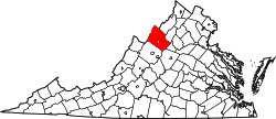
Location of the Massanetta Springs CDP within the Rockingham County
USA Virginia location map.svg
Red pog.svg
Massanetta Springs
Location within the Commonwealth of Virginia
Coordinates: 38°23′47″N78°49′54″W / 38.39639°N 78.83167°W / 38.39639; -78.83167 Coordinates: 38°23′47″N78°49′54″W / 38.39639°N 78.83167°W / 38.39639; -78.83167
CountryUnited States
State Virginia
County Rockingham
Population
 (2010)
  Total4,833
Time zone UTC−5 (Eastern (EST))
  Summer (DST) UTC−4 (EDT)
ZIP codes
22801
FIPS code 51-50020
GNIS feature ID2629754

Massanetta Springs is a census-designated place in Rockingham County, Virginia. The population as of the 2010 Census was 4,833. [1]

Related Research Articles

Saluda, Virginia

Saluda is a census-designated place (CDP) in and the county seat of Middlesex County, Virginia, United States. The population as of the 2010 Census was 769.

Ashburn, Virginia Census-designated place in Virginia

Ashburn is a census-designated place (CDP) in Loudoun County, Virginia, United States. As of the 2010 United States Census, its population was 43,511, up from 3,393 twenty years earlier. It is 30 miles (48 km) northwest of Washington, D.C., and part of the Washington metropolitan area.

Hot Springs, Virginia Census-designated place in Virginia, United States

Hot Springs is a census-designated place (CDP) in Bath County, Virginia, United States. The population as of the 2010 Census was 738. It is located about 5 miles southwest of Warm Springs on U.S. Route 220.

1800 United States census Census conducted in the United States in year 1800

The United States census of 1800 was the second census conducted in the United States. It was conducted on August 4, 1800.

Bland, Virginia Census-designated place in Virginia, United States

Bland is a census-designated place (CDP) in and the county seat of Bland County, Virginia, United States. Bland was originally known as Bland Court House. The population as of the 2010 Census was 409.

Mathews, Virginia Census-designated place in Virginia, United States

Mathews is a census-designated place (CDP) in and the county seat of Mathews County, Virginia, United States. Established around 1700, the small town of Westville was designated as the county seat in 1791. Today, it is variously known as Mathews Court House, as well as simply "Mathews," its official postal name.

Sussex is a census-designated place (CDP) in and the county seat of Sussex County, Virginia, United States. The population as of the 2020 Census was 181.

Nottoway, Virginia

Nottoway, or Nottoway Court House, is a census-designated place (CDP) in and the county seat of Nottoway County, Virginia, United States. The population as of the 2010 Census was 84.

The Huntington–Ashland metropolitan area is a metropolitan area in the Appalachian Plateau region of the United States. Referred to locally as the “Tri-State area”, and colloquially as "Kyova", the region spans seven counties in the three states of West Virginia, Kentucky, and Ohio. With a population of 361,580, the Tri-State area is nestled along the banks of the Ohio River. The region offers a diverse range of outdoor activities.

Greenbush, Virginia

Greenbush is a census-designated place (CDP) in Accomack County, Virginia, United States. The population as of the 2010 Census was 220.

Mappsville, Virginia

Mappsville is a census-designated place (CDP) in Accomack County, Virginia, United States. The population at the 2010 Census was 440.

Sanford, Virginia

Sanford is a census-designated place (CDP) in Accomack County, Virginia, United States. The population as of the 2010 Census was 212.

Captains Cove, Virginia CDP in Virginia, United States

Captains Cove is a census-designated place in Accomack County, Virginia. The population as of the 2010 Census was 1,042. Known as Captain's Cove Golf & Yacht Club, it is a recreational community located on the west shore of Chincoteague Bay, bordering Maryland to the north. While numerous families with children live here, it's largely a retirement community, with a median age of 51 and the largest age group being 60–64.

Makemie Park, Virginia CDP in Virginia, United States

Makemie Park is a census-designated place in Accomack County, Virginia. The population as of the 2010 Census was 155.

Oak Hall, Virginia CDP in Virginia, United States

Oak Hall is a census-designated place in Accomack County, Virginia. The population as of the 2010 Census was 255.

Pantops is a census-designated place in Albemarle County, Virginia. The population as of the 2010 Census was 3,027. It is a suburban area located just across the Rivanna River east of Charlottesville, and includes Pantops Mountain.

Piney Mountain is a census-designated place in Albemarle County, Virginia. The population as of the 2010 Census was 1,130. It is a suburban area located about ten miles north of Charlottesville, near the base of Piney Mountain, largely composed of the Briarwood and Camelot neighborhoods.

Rivanna is a census-designated place (CDP) in Albemarle County, Virginia, just east of Shadwell. The population as of the 2010 Census was 1,860. It consists mainly of the Glenmore gated community.

University of Virginia is a census-designated place in Albemarle County, Virginia. The population as of the 2010 Census was 7,704. As the name infers, the CDP encompasses the University of Virginia grounds, along with several adjacent off-grounds housing areas, including University Heights, which was formerly its own CDP.

References