Warrosquyoake Shire

Last updated
Map of the shires of Virginia, 1634 1634 Virginia Counties- Henrico Focus.jpg
Map of the shires of Virginia, 1634

Warrosquoake Shire (with numerous variant spellings, including Warrascoyack, [1] Warrascocke and "Warwick Squeak") was officially formed in 1634 in the Virginia colony, but had already been known as "Warascoyack County" before this. It was named for an Algonquian-speaking tribe that was part of the Powhatan Confederacy. The county was renamed Isle of Wight County in 1637, after an island in the English Channel.

History

Shortly after the establishment of Jamestown in 1607, English settlers explored and began settling areas adjacent to Hampton Roads. The shoreline region of the Warrascoyack River was occupied by the Warraskoyak tribe of the Powhatan Confederacy, under their weroance , Tackinekintaco. In December 1608, Captain John Smith left his page Samuel Collier with Tackinekintaco to learn the language. [2]

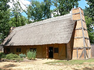
The main Warraskoyak village was located where present-day Smithfield, Virginia developed. A satellite village called Mokete was at Pagan Point, and another called Mathomank was on Burwell's Bay, led by a sub-weroance named Sasenticum.

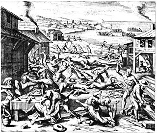
The first English plantation in the region, dating to 1618, was that of Puritan merchant Christopher Lawne. Several other Puritans also settled nearby. Edward Bennett, an English merchant and a free member of the London Company, was among those who got a land patent and founded his plantation in 1621. [1] He named his plantation Warrosquoake, [1] after the river which the indigenous people called by that name. His plantation suffered high fatalities of colonists in the Great Massacre of 1622, losing 53 persons. A total of the 347 colonists were killed that day, as the Powhatan tribes tried to kill and expel the English.

The surviving English retreated to a small number of plantations near Jamestown until an expedition was mounted against the Warraskoyak and Nansemond peoples. The colony built a fort nearby Bennett's plantation. [3] In reprisals during the following years, they drove off the Native Americans from their villages. A census of settlers at Bennett's plantation on 16 February 1623 showed a total of "33, including 4 negroes", with 20 settlers recorded at nearby Basse's Choice. A year later, a census showed a total population of 31 settlers for the region. [4]

Two of Bennett's brothers had managed his plantation and died in the colony, in 1624 and 126. Edward Bennett finally went to Virginia himself for a time, representing his plantation in the 1628 House of Burgesses, then returned to England.

His nephew Richard Bennett came out to manage the plantation, and stayed in the colony. He became a large landowner and eventually governor of the colony. In 1629, the "County of Warascoyack" was represented in the House of Burgeses was represented by Richard Bennett, Captain Nathaniel Basse (who owned Basse's Choice), Thomas Jordan and two others, all Puritans. [5] This was the Puritans' strongest representation in a colony dominated by members of the Anglican Church. [6]

By 1634, by order of the King of England, Charles I, eight shires of Virginia were formed, with a total population of 4,914 settlers. Warrosquoake Shire included 522 persons at the time. [7] It and Accomac Shire were the only shires given Native-American names, honoring the friendly tribes nearby. In 1637 the English renamed it Isle of Wight County, after an island of the same name in the English channel between England and France. They also renamed the Warrosquoake river the Pagan River.

During the three years when it was officially Warrosquoake Shire, Richard Bennett led the small Puritan community to neighboring Nansemond. They later moved to Maryland when under religious pressure in Virginia. He returned during the Cromwellian period with a Parliamentary Commission to take over from the Royalist government and served as Governor of Virginia.

As population increased, land was drawn from Warrosquoake Shire and Isle of Wight County to form many other counties to the immediate southwest, in the region now defined as Southside Virginia. The counties of Isle of Wight, Southampton, Greensville and Brunswick were all created within the limits of what had been Warrosquoake Shire.

Related Research Articles

<span class="mw-page-title-main">Isle of Wight County, Virginia</span> County in Virginia, United States

Isle of Wight County is a county located in the Hampton Roads region of the U.S. state of Virginia. It was named after the Isle of Wight, England, south of the Solent, from where many of its early colonists had come. As of the 2020 census, the population was 38,606. Its county seat is Isle of Wight, an unincorporated community.

<span class="mw-page-title-main">Colony of Virginia</span> British colony in North America (1606–1776)

The Colony of Virginia was an English, later British, colonial settlement in North America that existed between 1606 and 1776.

<span class="mw-page-title-main">John Rolfe</span> English-born explorer, farmer, and merchant

John Rolfe was an English explorer, farmer and merchant. He is best known for being the husband of Pocahontas and the first settler in the colony of Virginia to successfully cultivate a tobacco crop for export.

<span class="mw-page-title-main">Powhatan</span> Indigenous Algonquian tribes from Virginia, U.S.

The Powhatan people (;) are Native Americans who belong to member tribes of the Powhatan Confederacy, or Tsenacommacah. They are Algonquian peoples whose historic territories were in eastern Virginia.

<span class="mw-page-title-main">Nansemond County, Virginia</span> Former county in Virginia, United States (1646–1974)

Nansemond is an extinct jurisdiction that was located south of the James River in Virginia Colony and in the Commonwealth of Virginia in the United States, from 1646 until 1974. It was known as Nansemond County until 1972. From 1972 to 1974, a period of eighteen months, it was the independent city of Nansemond. It is now part of the independent city of Suffolk.

In the seventeenth century, Kecoughtan was the name of the settlement now known as Hampton, Virginia, In the early twentieth century, it was also the name of a town nearby in Elizabeth City County. It was annexed into the City of Newport News in 1927.

<span class="mw-page-title-main">Henricus</span> Archaeological site in Virginia, United States

The "Citie of Henricus"—also known as Henricopolis, Henrico Town or Henrico—was a settlement in Virginia founded by Sir Thomas Dale in 1611 as an alternative to the swampy and dangerous area around the original English settlement at Jamestown, Virginia. It was named for Henry, Prince of Wales (1594–1612), the eldest son of King James I.

<span class="mw-page-title-main">Weroance</span> Leader among the Powhatan confederacy of the Virginia coast and Chesapeake Bay region

Weroance is an Algonquian word meaning leader or commander among the Powhatan confederacy of the Virginia coast and Chesapeake Bay region. Weroances were under a paramount chief called Powhatan. The Powhatan Confederacy, encountered by the colonists of Jamestown and adjacent area of the Virginia Colony beginning in 1607, spoke an Algonquian language. Each tribe of the Powhatan Confederacy was led by its own weroance. Most foreign writers who have come across a weroance only did so on a special occasion. This is the case because a foreigner's presence was special. John Smith noted that there are few differences between weroances and their subjects.

<span class="mw-page-title-main">Native American tribes in Virginia</span>

The Native American tribes in Virginia are the Indigenous peoples whose tribal nations historically or currently are based in the Commonwealth of Virginia in the United States of America.

<span class="mw-page-title-main">Rappahannock people</span> Federally-recognized Native American tribe in Virginia

The Rappahannock are a federally recognized tribe in Virginia and one of the eleven state-recognized tribes. They are made up of descendants of several small Algonquian-speaking tribes who merged in the late 17th century. In January 2018, they were one of six Virginia tribes to gain federal recognition by passage of the Thomasina E. Jordan Indian Tribes of Virginia Federal Recognition Act of 2017.

<span class="mw-page-title-main">Tsenacommacah</span> Native homeland of the Powhatan people

Tsenacommacah is the name given by the Powhatan people to their native homeland, the area encompassing all of Tidewater Virginia and parts of the Eastern Shore. More precisely, its boundaries spanned 100 miles (160 km) by 100 miles (160 km) from near the south side of the mouth of the James River all the way north to the south end of the Potomac River and from the Eastern Shore west to about the Fall Line of the rivers.

<span class="mw-page-title-main">Anglo-Powhatan Wars</span> 17th-century conflicts between Virginia colonists and Algonquian Indians

The Anglo–Powhatan Wars were three wars fought between settlers of the Colony of Virginia and the Powhatan People of Tsenacommacah in the early 17th century. The first war started in 1609 and ended in a peace settlement in 1614. The second war lasted from 1622 to 1632. The third war lasted from 1644 until 1646 and ended when Opechancanough was captured and killed. That war resulted in a defined boundary between the Indians and colonial lands that could only be crossed for official business with a special pass. This situation lasted until 1677 and the Treaty of Middle Plantation which established Indian reservations following Bacon's Rebellion.

Kiskiack was a Native American tribal group of the Powhatan Confederacy in what is present-day York County, Virginia. The name means "Wide Land" or "Broad Place" in the native language, one of the Virginia Algonquian languages. It was also the name of their village on the Virginia Peninsula.

<span class="mw-page-title-main">History of Virginia Beach, Virginia</span>

The history of Virginia Beach, Virginia, goes back to the Native Americans who lived in the area for thousands of years before the English colonists landed at Cape Henry in April 1607 and established their first permanent settlement at Jamestown a few weeks later. The Colonial Virginia period extended until 1776 and the American Revolution, and the area has been part of the Commonwealth of Virginia ever since.

<span class="mw-page-title-main">Bennett Creek (Nansemond River tributary)</span>

Bennett Creek or Bennett's Creek is a 7.3-mile-long (11.7 km) tributary of the Nansemond River in Suffolk, Virginia.

Richard Bennett was an English planter and Governor of the Colony of Virginia, serving 1652–1655. He had first come to the Virginia colony in 1629 to represent his merchant uncle Edward Bennett's business, managing his plantation known as Bennett's Welcome in Warrascoyack. Two decades later, Bennett immigrated to the Maryland colony with his family, and settled on the Severn River in Anne Arundel County.

The Appomattoc were a historic tribe of Virginia Indians speaking an Algonquian language, and residing along the lower Appomattox River, in the area of what is now Petersburg, Colonial Heights, Chesterfield and Dinwiddie Counties in present-day southeast Virginia.

<span class="mw-page-title-main">History of Jamestown, Virginia (1607–1699)</span>

Jamestown, also Jamestowne, was the first settlement of the Virginia Colony, founded in 1607, and served as the capital of Virginia until 1699, when the seat of government was moved to Williamsburg. This article covers the history of the fort and town at Jamestown proper, as well as colony-wide trends resulting from and affecting the town during the time period in which it was the colonial capital of Virginia.

Edward Bennett, was an English merchant based in London, and a free member of the Virginia Company. A Puritan who had lived in Amsterdam for a period, he established the first large plantation in the colony of Virginia in North America, in what became known as Warrosquyoake Shire.

References

  1. 1 2 3 Tyler, Lyon Gardiner, ed. (1915). "Day, John". Encyclopedia of Virginia Biography. Vol. 1.
  2. Boddie, p. 2-3
  3. "James River Area - Fort Boykin". American Forts Network. Retrieved 10 August 2020.
  4. Boddie, p. 36
  5. Gentry, Daphne. "Nathaniel Basse (bap. 1589–1654)". Encyclopedia Virginia. Retrieved 24 August 2015.
  6. Boddie, p. 91
  7. Boddie, p. 172