These are the National Natural Landmarks in the U.S. state of Hawaii .
Name | Image | Date | Location | County | Ownership | Description | |
---|---|---|---|---|---|---|---|
1 | Diamond Head | Honolulu | Oahu | State Monument | Towering exposed basaltic cinder code, located within the middle of Honolulu's urban core. | ||
2 | I'ao Valley | Wailuku | Maui | State Monument | Eroded volcanic pinnacles covered in vegetation and surrounded by a lush rain forest. | ||
3 | Kanaha Pond | June 1971 | Kahului | Maui | State Wildlife Sanctuary | A brackish water bird refuge. | |
4 | Koʻolau Range Pali | Oahu | State & private land | Faulted, eroded mountain range is the remnant of a shield volcano. | |||
5 | Makalawena Marsh | 
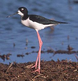
June 1972 | North Kona | Hawaiʻi | State Park | Located in Kekaha Kai State Park, site supports endangered birds such as the Hawaiian stilt. | |
6 | Mauna Kea | 
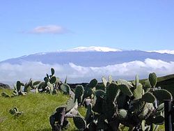
November 1972 | Saddle Road | Hawaiʻi | Federal & state land | 11,000 foot mountain is the world's finest example of a shield volcano. | |
7 | North Shore Cliffs | December 1972 | Molokaʻ | Maui | State & private lands | Contains steep, eroded volcanic cliffs. | |
Iao Valley is a lush, stream-cut valley in West Maui, Hawaii, located 3.1 miles (5 km) west of Wailuku. Because of its natural environment and history, it has become a tourist location. It was designated a National Natural Landmark in 1972.
Diamond Head is a volcanic tuff cone on the Hawaiian island of Oʻahu and known to Hawaiians as Lēʻahi. The Hawaiian name is most likely derived from lae plus ʻahi (tuna) because the shape of the ridgeline resembles the shape of a tuna's dorsal fin. Its English name was given by British sailors in the 19th century, who named it for the calcite crystals on the adjacent beach.
Washington Place is a Greek Revival palace in the Hawaii Capital Historic District in Honolulu, Hawaiʻi. It was where Queen Liliʻuokalani was arrested during the overthrow of the Hawaiian Kingdom. Later it became the official residence of the governor of Hawaiʻi. In 2007, it was designated as a National Historic Landmark. The current governor's residence was built in 2008 behind the historic residence, and is located on the same grounds as Washington Place.
Kohala is the name of the northwest portion of the island of Hawaiʻi in the Hawaiian Archipelago. In ancient Hawaii it was often ruled by an independent High Chief called the Aliʻi Nui. In modern times it is divided into two districts of Hawaii County: North Kohala and South Kohala. Locals commonly use the name Kohala to refer to the census-designated places of Halaʻula, Hāwī, and Kapaʻau collectively. The dry western shore is commonly known as the Kohala Coast, which has golf courses and seaside resorts.
Koʻolau Range is a name given to the dormant fragmented remnant of the eastern or windward shield volcano of the Hawaiian island of Oʻahu. It was designated a National Natural Landmark in 1972.
The National Natural Landmarks (NNL) Program recognizes and encourages the conservation of outstanding examples of the natural history of the United States. It is the only national natural areas program that identifies and recognizes the best examples of biological and geological features in both public and private ownership. The program was established on May 18, 1962, by United States Secretary of the Interior Stewart Udall.
Kaloko-Honokōhau National Historical Park is a United States National Historical Park located in the Kona District on the Big island of Hawaiʻi in the U.S. state of Hawaiʻi. It includes the National Historic Landmarked archaeological site known as the Honokōhau Settlement. The park was established on November 10, 1978, for the preservation, protection and interpretation of traditional native Hawaiian activities and culture.
Russian Fort Elizabeth is a National Historic Landmark and is administered as the Russian Fort Elizabeth State Historical Park just southeast of present-day Waimea on the island of Kauaʻi in Hawaiʻi. It is located at the site of the former Fort Elizavety, the last remaining Russian fort on the Hawaiian islands, built in the early 19th century by the Russian-American Company as the result of an alliance with High Chief Kaumualiʻi. The star fort was employed by the Kingdom of Hawaii in the 19th century under the name Fort Hipo.
This is a list of properties and historic districts in Hawaii listed on the National Register of Historic Places. More than 340 listings appear on all but one of Hawaii's main islands and the Northwestern Islands, and in all of its five counties. Included are houses, schools, archeological sites, ships, shipwrecks and various other types of listings. These properties and districts are listed by island, beginning at the northwestern end of the chain.
Kanaha Pond State Wildlife Sanctuary is a 143-acre (58 ha) wetland in Maui, Hawaii. This waterfowl sanctuary attracts two endangered Hawaiian bird species, the Hawaiian coot and the Hawaiian stilt (aeʻo). Kanaha Pond was designated a state sanctuary in 1951 and a National Natural Landmark in 1971. The site has hosted numerous vagrant birds, including Gray-tailed Tattler and Belted Kingfisher, as well as Hawaii's first record of Black-tailed Godwit.
The Historic Preservation Fund (HPF) provides financial support for historic preservation projects throughout the United States. The fund is administered by the National Park Service (NPS), pursuant to the National Historic Preservation Act of 1966 (NHPA). The fund provides state historic preservation agencies with matching funds to implement the act.
The Hawaiian coot, also known as the ʻalae kea in Hawaiian, is a bird in the rail family, Rallidae, that is endemic to Hawaiʻi. In Hawaiian, ʻalae is a noun and means mud hen. Kea or its synonym keo is an adjective for white. It is similar to the American coot at 33–40.6 cm (13–16 in) in length and weighing around 700 g. It has black plumage and a prominent white frontal shield. Its natural habitats are freshwater lakes, freshwater marshes, coastal saline lagoons, and water storage areas. The bird was federally listed in October 1970 as an endangered species and is considered both endemic and endangered by the state of Hawaii. It is threatened by habitat loss and introduced predators such as the small Asian mongoose. The Makalawena Marsh on the Big Island of Hawaiʻi has been listed as a National Natural Landmark to preserve one of its last nesting areas.
The Hokukano-Ualapue Complex is a National Historic Landmarked pre-contact archaeological site on several properties adjacent to Hawaii Route 450 in Ualapue, on Molokaʻi island. The complex includes six heiaus and two fishponds. The complex is one of the most important collections of native Hawaiian sites in Hawaiʻi. It was designated a National Historic Landmark in 1962 and added to the National Register of Historic Places on October 15, 1966.
Kekaha Kai State Park, formerly known as Kona Coast State Park, is a beach park located along the north Kona coast on the island of Hawaiʻi. The main beach areas are Maniniʻowali Bay, Makalawena beach at Puʻu Aliʻi Bay, and Mahaiʻula Bay. The park's name originates from the Hawaiian language words ke kaha kai which translate to "the shore line" in English.
The following outline is provided as an overview of and topical guide to the U.S. state of Hawaii:
This is a list of properties and districts on the island of Hawaiʻi in the U.S. state of Hawaiʻi that are listed on the National Register of Historic Places. The island is coterminous with Hawaiʻi County, the state's only county that covers exactly one island. There are 93 properties and districts on the island, including 10 historic districts, six National Historic Landmarks, and one National Historic Landmark District.
The Mauna Kea Ice Age Natural Area Reserve is a Hawaii state natural reserve that includes the Mauna Kea Adz Quarry, on the southern slope of Mauna Kea on the island of the Hawaiʻi.
Matafao Peak is a mountain in American Samoa, on the island of Tutuila. With an elevation of 653 meters (2,142 ft), it is the highest peak on Tutuila Island. The mountain, like Rainmaker Mountain across Pago Pago Harbor, is a remnant of a volcanic plug and is part of the volcanic origins of the island. The mountain can be hiked from the high point of the Pago Pago-to-Fagasa Road. It is designated a National Natural Landmark above the 492-foot level, an area known as Matafao Peak National Natural Landmark.
Taputimu is a village in southwestern Tutuila Island in American Samoa. It is the nearest village to the Fagatele Bay National Marine Sanctuary, although the main access is from the neighboring village of Futiga. It is home to Leala Shoreline National Natural Landmark and Leala Sliding Rock. Leala Sliding Rock is a natural rock formation between Vailoatai and Taputimu, which is a scenic landmark as well as a natural playground or slide. It was created by the ebb and flow of the ocean; the erosion has created a smooth shoreline site. It is located in Tualatai County in the Western District of Tutuila.