Hawaiʻi is the largest island located in the U.S. state of Hawaii. It is the largest and the southeasternmost of the Hawaiian Islands, a chain of volcanic islands in the North Pacific Ocean. With an area of 4,028 square miles (10,430 km2), it has 63% of the Hawaiian archipelago's combined landmass, and is the largest island in the United States. However, it has only 13% of Hawaiʻi's people. The island of Hawaiʻi is the third largest island in Polynesia, behind the two main islands of New Zealand.

Hilo is a census-designated place (CDP) and the largest city in Hawaii County, Hawaii, United States, which encompasses the Island of Hawaiʻi. The population was 43,263 according to the 2010 census.

Mauna Loa is one of five volcanoes that form the Island of Hawaii in the U.S. state of Hawaiʻi in the Pacific Ocean. The largest subaerial volcano in both mass and volume, Mauna Loa has historically been considered the largest volcano on Earth, dwarfed only by Tamu Massif. It is an active shield volcano with relatively gentle slopes, with a volume estimated at approximately 18,000 cubic miles (75,000 km3), although its peak is about 125 feet (38 m) lower than that of its neighbor, Mauna Kea. Lava eruptions from Mauna Loa are silica-poor and very fluid, and they tend to be non-explosive.

Mauna Kea is a dormant volcano on the island of Hawaiʻi. Its peak is 4,207.3 m (13,803 ft) above sea level, making it the highest point in the state of Hawaiʻi. Most of the volcano is underwater, and when measured from its underwater base, Mauna Kea is the tallest mountain in the world, measuring 10,211 m (33,500 ft) in height. It is about a million years old, and has thus passed the most active shield stage of life hundreds of thousands of years ago. In its current post-shield state, its lava is more viscous, resulting in a steeper profile. Late volcanism has also given it a much rougher appearance than its neighboring volcanoes due to construction of cinder cones, decentralization of its rift zones, glaciation on its peak, and weathering by the prevailing trade winds. Mauna Kea last erupted 6,000 to 4,000 years ago and is now considered dormant. The peak is about 38 m (125 ft) higher than Mauna Loa, its more massive neighbor.
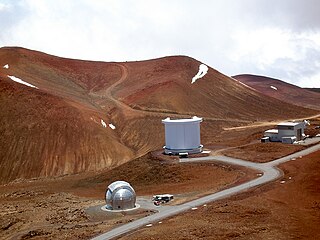
The Mauna Kea Observatories (MKO) are a number of independent astronomical research facilities and large telescope observatories that are located at the summit of Mauna Kea on the Big Island of Hawaiʻi, United States. The facilities are located in a 525-acre (212 ha) special land use zone known as the "Astronomy Precinct", which is located within the 11,228-acre (4,544 ha) Mauna Kea Science Reserve. The Astronomy Precinct was established in 1967 and is located on land protected by the Historical Preservation Act for its significance to Hawaiian culture. The presence and continued construction of telescopes is highly controversial due to Mauna Kea's centrality in native Hawaiian religion and culture, as well as for a variety of environmental reasons.

Hualālai is an active volcano on the island of Hawaiʻi in the Hawaiian Islands. It is the westernmost, third-youngest and the third-most active of the five volcanoes that form the island of Hawaiʻi, following Kīlauea and the much larger Mauna Loa. Its peak stands 8,271 feet (2,521 m) above sea level. Hualālai is estimated to have risen above sea level about 300,000 years ago. Despite maintaining a very low level of activity since its last eruption in 1801, and being unusually inactive for the last 2,000 years, Hualālai is still considered active, and is expected to erupt again some time within the next century. The relative unpreparedness of the residents in the area caused by the lull in activity would worsen the consequences of such an event.

Hawaiʻi Volcanoes National Park is an American national park located in the U.S. state of Hawaii on the island of Hawaii. The park encompasses two active volcanoes: Kīlauea, one of the world's most active volcanoes, and Mauna Loa, the world's most massive shield volcano. The park provides scientists with insight into the development of the Hawaiian Islands and access for studies of volcanism. For visitors, the park offers dramatic volcanic landscapes, glimpses of rare flora and fauna, and a view into the traditional Hawaiian culture connected to these landscapes.
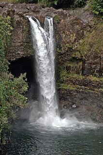
The Wailuku River is a 28.0-mile-long (45.1 km) water course on the Island of Hawaiʻi in the Hawaiian Islands. It is the longest river in Hawai'i and the largest in the state by mean discharge. Its course lies mostly along the divide between the lava flows of Mauna Kea and those of Mauna Loa to the south. It arises at about the 10,800 feet (3,300 m) elevation along the eastern slope of Mauna Kea. It flows generally eastward, descending steeply from the mountain and entering the Pacific Ocean at Hilo.

Route 200, known locally as Saddle Road, traverses the width of the Island of Hawaiʻi, from downtown Hilo to its junction with Hawaii Route 190 near Waimea. The road was once considered one of the most dangerous paved roads in the state, with many one-lane bridges and areas of marginally maintained pavement. Most of the road has now been repaved, and major parts have new re-alignments to modern standards. The highway is mostly one-lane in each direction, but there are two lanes on the uphill portions. The highway reaches a maximum elevation of 6,632 feet (2,021 m) and is subject to fog and low visibility. Many rental car companies used to prohibit use of their cars on Saddle Road, but now allow use of the road. The highway experiences heavy use as it provides the shortest driving route from Hilo to Kailua-Kona and access to the slopes of Mauna Loa and the Mauna Kea Observatories.

Hāpuna Beach State Recreation Area is a large park and sandy beach on the Big Island of Hawaii. The Hapuna Beach Prince Hotel is also located adjacent to the beach. Hāpuna is popular with residents and visitors.

Hāmākua is a district on the northeast coast of Hawaiʻi's Big Island, administered by the County of Hawaiʻi in the state of Hawaiʻi. It is also the name given for the coastline in the region, the "Hāmākua Coast".

Lake Waiau is a high-elevation lake located at 3,970 m (13,020 ft) above sea level on Mauna Kea, on the island of Hawaiʻi. It is arguably one of the highest lakes in the United States. After the evaporation of Ka Wai o Pele in 2018 and the short-lived lake in Halema'uma'u crater in 2020, Lake Waiau is the only lake on Hawaiʻi Island and one of very few lakes at all in the state of Hawaiʻi. It is relatively small, only about 100 m across, and varies in size as the water level rises and falls. At high water levels a small outlet stream appears at the northwest end, but it is absorbed into the ground after a short distance. The name means "swirling water" in Hawaiian, though it is usually rather placid. It usually freezes in winter, but aquatic insects such as midges and beetles can be found breeding in the water.

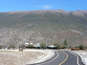
Pōhakuloa Training Area (PTA) is located on the island of Hawaiʻi in the high plateau between Mauna Loa, Mauna Kea and the Hualālai volcanic mountains. It includes a small military airstrip known as Bradshaw Army Airfield.

Kaunaʻoa Bay has one of the few white sand beaches of the Kohala Coast, the western side of the island of Hawaiʻi. A historic hotel, the Mauna Kea Beach Hotel, is located on beautiful Kauna'oa.

The Mauna Kea Trail, also known as the Humuʻula Trail, is a hiking route leading from the Onizuka Center for International Astronomy to the summit of Mauna Kea, the highest volcano on the island of Hawaiʻi. The trail is a 6 mi (10 km) long, unmaintained dirt and scree path with two short road sections, about 600 ft (180 m) at the beginning and about 1 mi (1.6 km) near the summit. Cairns and reflective posts mark the route above 10,000 ft (3,000 m).
The Onizuka Center for International Astronomy, also known as Hale Pōhaku, is a complex of support facilities for the telescopes and other instruments that comprise the Mauna Kea Observatory atop Mauna Kea, on Hawaiʻi island.

The Mauna Kea Ice Age Natural Area Reserve is a Hawaii state natural reserve that includes the Mauna Kea Adz Quarry, on the southern slope of Mauna Kea on the island of the Hawaiʻi.
Silene hawaiiensis is a rare species of flowering plant in the family Caryophyllaceae known by the common names Hawai'i catchfly, Hawaiian catchfly and Sherff's catchfly. It is endemic to Hawaii, where it is known only from the island of Hawaii. It is threatened by the degradation of its habitat and it is a federally listed threatened species of the United States.

Waiākea-Uka (IPA:/'waj.ə.kei.ə.'u.kə/) is an ancient subdivision (ahupuaʻa) in the Hilo District of the Big Island of Hawaiʻi, located mauka (mountain-side) of the Waiākea ahupua'a; its location is on the lower flanks of the volcano Mauna Loa. Because of this, one meaning of the name 'Waiākea-Uka' can be translated from 'Olelo Hawai'i as '(the) mountain-side (of) Waiākea'. Many ahupua'a have this -uka appellation, as the directions 'mountain-side' and 'sea-side' (makai) are the two best ways of orientating something in space on any of the islands.

Puʻu Huluhulu is a volcanic cone located near the center of the Island of Hawaii in the State of Hawaii. It is located on the southern side of Hawaii Route 200, directly across from the highway's intersection with the Mauna Kea Access Road. Puʻu Huluhulu is Hawaiian for hairy hill.