
Clay Pit Ponds State Park Preserve is 265-acre (1.07 km2) state park located near the southwestern shore of Staten Island, New York. It is the only state park located on Staten Island.

The Monongahela National Forest is a national forest located in the Allegheny Mountains of eastern West Virginia, USA. It protects over 921,000 acres of federally owned land within a 1,700,000 acres proclamation boundary that includes much of the Potomac Highlands Region and portions of 10 counties.
Massasoit State Park is a public recreation area located on the southeast side of the city of Taunton, Massachusetts, with some parklands spilling into the adjacent town of Lakeville. The state park encompasses more than 1200 heavily wooded acres that include six lakes and ponds and numerous cranberry bogs.

Buffalo Mountain Natural Area Preserve is a 1,140-acre (4.6 km2) Natural Area Preserve in Floyd County, Virginia.

Cherry Orchard Bog Natural Area Preserve is a 354-acre (143 ha) Natural Area Preserve located in Sussex and Prince George counties, Virginia. It preserves a seepage wetland that supports a large collection of rare plants, including camass, bog-buttons, fringed orchids, and purple pitcher plants. The property is located along the right of way for a power line, receiving acidic, low-nutrient groundwater.
Cleveland Barrens Natural Area Preserve is a 1,288-acre (5.21 km2) Natural Area Preserve located within the Clinch River Valley in Russell County, Virginia.
Cowbane Prairie Natural Area Preserve is a 63-acre (25 ha) Natural Area Preserve located in Augusta County, Virginia, along the western slope of the Blue Ridge in the Shenandoah Valley. It preserves both mesic and wet prairie habitats, as well as a calcareous spring-fed marsh; these areas contain eleven regionally rare plants such as queen-of-the-prairie, blueflag iris, and marsh-speedwell. Although common in the Midwest, these plants occur only at a handful of sites in Virginia.
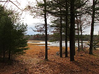
Deep Run Ponds Natural Area Preserve is a 706-acre (2.86 km2) Natural Area Preserve in Rockingham County, Virginia. The preserve contains one of the largest remaining systems of Shenandoah Valley sinkhole ponds in Virginia. Such ponds are found in Rockingham and Augusta counties; their water levels fluctuate throughout the year. The preserve's eight sinkhole ponds support a variety of rare plant and animal life; two ponds support the rare Virginia sneezeweed, while others contain black-fruited spikerush, northern St. John's-wort, Buxbaum's sedge, and northern bog clubmoss.
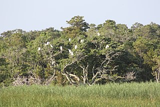
False Cape Natural Area Preserve is a 3,573-acre (14.46 km2) Natural Area Preserve located in Virginia Beach, Virginia, just north of the state border with North Carolina. The preserve covers a one-by-six-mile strip of largely undeveloped land located on False Cape between the Atlantic Ocean and Back Bay, and is one of the most undisturbed areas of coastal habitat remaining in the Mid-Atlantic.

Folly Mills Creek Fen Natural Area Preserve is a Natural Area Preserve located in Augusta County, Virginia. The preserve was dedicated in 1998, and was the first privately owned Natural Area Preserve to be dedicated in the state.
Grayson Glades Natural Area Preserve is a 31-acre (13 ha) Natural Area Preserve located in Grayson County, Virginia. Its centerpiece is an extremely rare wetland type known as a "mafic fen", which are situated upon soils rich in magnesium and fed by springs. The site is at the headwaters of a small stream system supporting additional mafic fens.
Mutton Hunk Fen Natural Area Preserve is a 516-acre (2.09 km2) Natural Area Preserve located in Accomack County, Virginia. Fronting on the Atlantic Ocean's Gargathy Bay to the east, it is also bounded by Whites Creek and Mutton Hunk Branch to its north. The property contains a rare "sea level fen" community, one of only four in Virginia. Despite the proximity to the ocean's saltwater, freshwater wetland plants are able to survive in this environment due to the influence of freshwater springs. Acidic conditions also encourage the growth of plants normally found in bogs, in addition to tidal freshwater wetland plants; five of the species found at the preserve are regionally rare.
Pinnacle Natural Area Preserve is an 891-acre (361 ha) Natural Area Preserve in Russell County, Virginia. Located at the confluence of the Clinch River and Big Cedar Creek, the preserve's namesake and centerpiece is the Pinnacle, a dolomite formation rising 400 feet (120 m) above the creek.
Pedlar Hills Glades Natural Area Preserve is a 1,036-acre (4.19 km2) Natural Area Preserve located in Montgomery County, Virginia. Rising over the South Fork of the Roanoke River, it supports numerous rare plants and natural communities, including a dolomite barren. Among the species found within the preserve are tall gay-feather and Addison's leatherflower, the latter endemic to Virginia.
Redrock Mountain Natural Area Preserve is a 640-acre (260 ha) Natural Area Preserve located in Smyth County, Virginia. The preserve is named for the 4,413-foot (1,345 m) Redrock Mountain, which itself is named for its red siltstone cliffs. It supports a number of rare natural features, and two natural community types, including examples of "mountain/piedmont basic woodlands" upon the mountain's slopes, and "rich cove/slope forests" in the preserve's lowlands. Five rare plant species are found on the property, including spring blue-eyed Mary, fringed scorpion-weed, and Carey saxifrage.
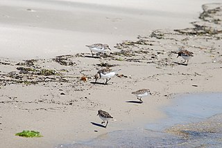
Savage Neck Dunes Natural Area Preserve is a 298-acre (121 ha) Natural Area Preserve located in Northampton County, Virginia on the Chesapeake Bay. Fifty-foot-tall (15 m) dunes within the preserve are among the highest points on Virginia's Eastern Shore. The preserve contains beach, dune, and maritime forest natural communities of various sorts, as well as habitat for migratory songbirds and northeastern beach tiger beetles. Regionally rare plants at the preserve include Engelmann's umbrella-sedge, dwarf burhead, and southern bladderwort.
The Cedars Natural Area Preserve is a Natural Area Preserve located in Lee County, Virginia. It protects rare plant and animal species adapted to the unique conditions of a karst landscape.


