
The George Washington and Jefferson National Forests is an administrative entity combining two U.S. National Forests into one of the largest areas of public land in the Eastern United States. The forests cover 1.8 million acres (2,800 sq mi) of land in the Appalachian Mountains of Virginia, West Virginia, and Kentucky. Approximately 1 million acres (1,600 sq mi) of the forest are remote and undeveloped and 139,461 acres (218 sq mi) have been designated as wilderness areas, which prohibits future development.
Mountain Lake Wilderness is a U.S. Wilderness Area in the George Washington and Jefferson National Forests. The wilderness area is located next to privately owned Mountain Lake, and consists of 8,314 acres (3,365 ha) in Virginia and 2,721 acres (1,101 ha) in West Virginia.

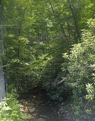
The Mountain Lake Wilderness Cluster is a region recognized by The Wilderness Society for its unique waterfalls, vistas, trout stream and wildlife habitat. The heart of the region is the Mountain Lake Wilderness, the largest wilderness in the George Washington and Jefferson National Forests. These public lands are enhanced by the presence of private lands which are preserved to maintain their natural integrity. The region includes the Mountain Lake Biological Station that studies distinctive wildlife and ecology of the area.
Beartown Wilderness is a U.S. wilderness area in the Eastern Divide Ranger District of the George Washington and Jefferson National Forests. The Wilderness consists of 5,613 acres (22.72 km2) of land with elevations ranging from 2,400 to 4,800 feet. It was created from existing National Forest lands in 1984 by the Virginia Wilderness Act of 1984.
Garden Mountain Wilderness is a U.S. wilderness area in the Eastern Divide Ranger District of the George Washington and Jefferson National Forests. It is a small wilderness area in western Virginia, consisting of an area of 3,331 acres (13.48 km2) and bordering the Beartown and Hunting Camp Creek Wilderness. It was designated as wilderness area in 2009 by Omnibus Public Land Management Act of 2009. The wilderness area also borders a portion of the Appalachian Trail.

Brush Mountain East Wilderness is a U.S. wilderness area in the Eastern Divide Ranger District of the George Washington and Jefferson National Forests. It was designated as wilderness area in 2009 by Omnibus Public Land Management Act of 2009. The wilderness is adjacent to Brush Mountain Wilderness.

The Thunder Ridge Wilderness is a 2,344 acres (949 ha) area located near Natural Bridge, Virginia, which is protected by the Eastern Wilderness Act of Congress to maintain its present, natural condition. As part of the National Wilderness Preservation System, it helps to preserve a variety of natural life forms and contributes to a diversity of plant and animal gene pools. Over half of the ecosystems in the United States exist within designated wilderness.

The Shawvers Run Wilderness, a 5784-acre area located less than one mile south of Potts Creek, Virginia, is protected by the Eastern Wilderness Act of Congress to maintain its present, natural condition. As part of the National Wilderness Preservation System, it helps to preserve a variety of natural life forms and contributes to a diversity of plant and animal gene pools. Over half of the ecosystems in the United States exist within designated wilderness.

The Kimberling Creek Wilderness is an area protected by the Eastern Wilderness Act of Congress to maintain its present, natural condition. It is managed as part of the Jefferson National Forest. As part of the wilderness system, it helps to preserve a variety of natural life forms and contributes to a diversity of plant and animal gene pools. Over half of the ecosystems in the United States exist within designated wilderness.
The Hunting Camp Creek Wilderness is an area protected by the Eastern Wilderness Act of Congress to maintain its present, natural condition. As part of the wilderness system, it helps to preserve a variety of natural life forms and contributes to a diversity of plant and animal gene pools. Over half of the ecosystems in the United States exist within designated wilderness.
The Lynn Camp Creek Wilderness Study Area, a 3226-acre site in the Eastern Divide Ranger District of the George Washington and Jefferson National Forests, was designated a wilderness study area by the Omnibus Public Lands Act of 2009.
The Raccoon Branch Wilderness is an area in the Mount Rogers National Recreation Area protected by the Eastern Wilderness Act of Congress to maintain its present, natural condition. As part of the wilderness system, it is intended to preserve a variety of natural life forms and contribute to a diversity of plant and animal gene pools. Over half of the ecosystems in the United States exist within designated wilderness.
The Little Wilson Creek Wilderness is an area in the Mount Rogers National Recreation Area protected by the Eastern Wilderness Act of Congress to maintain its present, natural condition. As part of the wilderness system, it is intended to preserve a variety of natural life forms and contribute to a diversity of plant and animal gene pools. Over half of the ecosystems in the United States exist within designated wildernesses.

The Lewis Fork Wilderness is an area in the Mount Rogers National Recreation Area protected by the Eastern Wilderness Act of Congress to maintain its present, natural condition. As part of the wilderness system, it is intended to preserve a variety of natural life forms and contribute to a diversity of plant and animal gene pools. Over half of the ecosystems in the United States exist within designated wilderness.

The Mount Rogers Cluster is a region recognized by The Wilderness Society for its unique high elevation mountains, vistas, trout streams and wildlife habitat. The heart of the region is Mount Rogers, the highest mountain in Virginia. The area extends over the Mount Rogers National Recreation Area and into part of the Cherokee National Forest.
Hoop Hole, a wildland in the George Washington and Jefferson National Forests of western Virginia, has been recognized by the Wilderness Society as a special place worthy of protection from logging and road construction. The Wilderness Society has designated the area as a "Mountain Treasure".
Barbours Creek Wilderness Addition, a wildland in the George Washington and Jefferson National Forests of western Virginia, has been recognized by the Wilderness Society as a special place worthy of protection from logging and road construction. The Wilderness Society has designated the area as a "Mountain Treasure".
Potts Arm, a wildland in the George Washington and Jefferson National Forests of western Virginia, has been recognized by the Wilderness Society as a special place worthy of protection from logging and road construction. The Wilderness Society has designated the area as a "Mountain Treasure".
The Barbours Creek-Shawvers Run Cluster is a region in the Jefferson National Forest recognized by The Wilderness Society for its unique high elevation mountains, vistas, trout streams and wildlife habitat. With over 25,000 acres in a remote corner of the national forest, the cluster provides protection for black bear, clean water and backcountry hiking.

The Sinking Creek Valley Cluster is a region in the Jefferson National Forest recognized by The Wilderness Society for its unique recreational and scenic values as well as the importance of its watershed protection for Johns Creek and Craig Creek. Sinking Creek Valley is one of the most scenic valleys in Virginia.


