Shawvers Run Wilderness

Last updated
Shawvers Run Wilderness
Shawvers Run, from Va 607, 15 oct 17.jpg
Shawvers Run, from Va 607, 15 oct 17
USA Virginia relief location map.svg
Red pog.svg
Location Craig County Virginia, United States
Nearest city Potts Creek, Virginia
Coordinates 37°35′11″N80°12′20″W / 37.58626°N 80.20569°W / 37.58626; -80.20569 Coordinates: 37°35′11″N80°12′20″W / 37.58626°N 80.20569°W / 37.58626; -80.20569
Area5,784 acres (2,341 ha)
Established1988
Administrator U.S. Forest Service

The Shawvers Run Wilderness, a 5784-acre area located less than one mile south of Potts Creek, Virginia, is protected by the Eastern Wilderness Act of Congress to maintain its present, natural condition. As part of the National Wilderness Preservation System, it helps to preserve a variety of natural life forms and contributes to a diversity of plant and animal gene pools. Over half of the ecosystems in the United States exist within designated wilderness. [1] [2]

Contents

A viewpoint on Hanging Rock overlooks the Shawvers Run Wilderness, Hanging Rock Valley, Peters Mountain Wilderness, and Potts Creek Valley. [3]

The area is part of the Barbours Creek-Shawvers Run Cluster .

Location and access

Potts Mountain Rd (Forest Service Rd 177-1) next to Shawvers Run Wilderness in southwest Virginia Potts Mountain Rd (Forest Service Rd 177-1) next to Shawvers Run Wilderness in southwest Virginia.jpg
Potts Mountain Rd (Forest Service Rd 177-1) next to Shawvers Run Wilderness in southwest Virginia

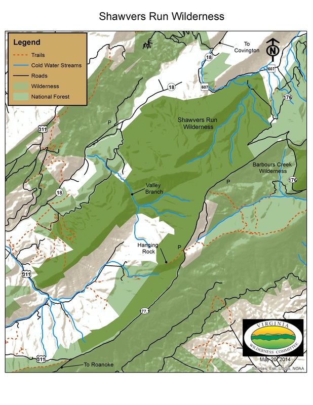
Located in the Eastern Divide Ranger District of the Jefferson National Forrest, the wilderness falls between the crest of Potts Mountain on the southeast and Va 18 on the northwest. [4]

The only official trail in the area, the Hanging Rock Trail, is a 0.7 mile hike to a viewpoint over the area from Hanging Rock. The trailhead is on Forest Service Road 177-1. [4]

The Valley Branch Trail is an unofficial trail, 2.7 miles long, with a trailhead on Forest Service Road 177-1 [5]

Natural History

Populations of native brook trout are found in Valley Branch Creek and Shawvers Run. [3] Besides the oak-hickory forest common to the Jefferson Forest, the wilderness contains poplar, birch, hemlock and white pine along Valley Branch, and, in the dry section to the west of Potts Mountain, Virginia pine and chestnut oak. [5]

The slopes of the wilderness provide watershed protection for the federally endangered James River spinymussel found in Potts Creek. [3]

Topography

Hanging Rock viewed from Va 603 in Hanging Rock Valley Hanging Rock viewed from Va 603 in Hanging Rock Valley, 15 oct 17.jpg
Hanging Rock viewed from Va 603 in Hanging Rock Valley

The wilderness lies on the western slope of Potts Mountain, in the Ridge and Valley Province of Virginia and West Virginia. The terrain is a complex anticlinal structure capped by erosion-resistant Silurian sandstone. The mountain ridge is about 3700 feet in elevation without prominent knobs; the lowest elevation is along Shawvers Run at about 2000 feet. [6] Shawvers Run and Valley Branch are the two largest waterways draining the area. [5]

The southwestern end of the wilderness surrounds Hanging Rock Valley, part of a karst system with large caves including the two-mile long Patton Cave and Panther Cave. [3]

Nearby wild areas

See also

Barbours Creek-Shawvers Run Cluster

Related Research Articles

George Washington and Jefferson National Forests Pair of National Forests in the United States

The George Washington and Jefferson National Forests is an administrative entity combining two U.S. National Forests into one of the largest areas of public land in the Eastern United States. The forests cover 1.8 million acres (7,300 km2) of land in the Appalachian Mountains of Virginia, West Virginia, and Kentucky. Approximately 1 million acres (4,000 km2) of the forest are remote and undeveloped and 139,461 acres (564 km2) have been designated as wilderness areas, which eliminates future development.

Mountain Lake Wilderness

Mountain Lake Wilderness is a U.S. Wilderness Area in the George Washington and Jefferson National Forests. The wilderness area is located next to privately owned Mountain Lake, and consists of 8,314 acres (3,365 ha) in Virginia and 2,721 acres (1,101 ha) in West Virginia.

Paint Bank, Virginia Unincorporated community in Virginia, United States

Paint Bank is an unincorporated community in northern Craig County, Virginia, United States. It is located at the intersection of State Route 18 and State Route 311 northwest of the town of New Castle, the county seat. The village is located between Potts Mountain and Peters Mountain.

Cascades (conservation area)

Cascades is an area in the George Washington and Jefferson National Forests of western Virginia, United States, that has been recognized by the Wilderness Society as a special place worthy of protection from logging and road construction The area is named after a 60-foot waterfall on Little Stony Creek which flows out of the area into the New River.

Mountain Lake Wilderness Cluster

The Mountain Lake Wilderness Cluster is a region recognized by The Wilderness Society for its unique waterfalls, vistas, trout stream and wildlife habitat. The heart of the region is the Mountain Lake Wilderness, the largest wilderness in the George Washington and Jefferson National Forests. These public lands are enhanced by the presence of private lands which are preserved to maintain their natural integrity. The region includes the Mountain Lake Biological Station that studies distinctive wildlife and ecology of the area.

Barbours Creek Wilderness

Barbours Creek Wilderness is a U.S. wilderness area in the Eastern Divide Ranger District of George Washington and Jefferson National Forests of western Virginia, United States. The wilderness area was established in 1988 and consists of 5,382 acres (2,178 ha) of forests in the Appalachian Mountains ranging in elevation from 1,700 to 3,800 feet.

Little Dry Run Wilderness

The Little Dry Run Wilderness is an area in the Mount Rogers National Recreation Area protected by the Eastern Wilderness Act of Congress to maintain its present, natural condition. As part of the wilderness system, it is intended to preserve a variety of natural life forms and contribute to a diversity of plant and animal gene pools. Over half of the ecosystems in the United States exist within designated wilderness.

Raccoon Branch Wilderness

The Raccoon Branch Wilderness is an area in the Mount Rogers National Recreation Area protected by the Eastern Wilderness Act of Congress to maintain its present, natural condition. As part of the wilderness system, it is intended to preserve a variety of natural life forms and contribute to a diversity of plant and animal gene pools. Over half of the ecosystems in the United States exist within designated wilderness.

Little Wilson Creek Wilderness

The Little Wilson Creek Wilderness is an area in the Mount Rogers National Recreation Area protected by the Eastern Wilderness Act of Congress to maintain its present, natural condition. As part of the wilderness system, it is intended to preserve a variety of natural life forms and contribute to a diversity of plant and animal gene pools. Over half of the ecosystems in the United States exist within designated wilderness.

Lewis Fork Wilderness

The Lewis Fork Wilderness is an area in the Mount Rogers National Recreation Area protected by the Eastern Wilderness Act of Congress to maintain its present, natural condition. As part of the wilderness system, it is intended to preserve a variety of natural life forms and contribute to a diversity of plant and animal gene pools. Over half of the ecosystems in the United States exist within designated wilderness.

Broad Run (conservation area) Protected natural area in Virginia, United States

Broad Run, a wildland in the George Washington and Jefferson National Forests of western Virginia, has been recognized by the Wilderness Society as a special place worthy of protection from logging and road construction. The Wilderness Society has designated the area as a "Mountain Treasure".

Price Mountain (conservation area) Protected natural area in Virginia, United States

Price Mountain, a wildland in the George Washington and Jefferson National Forests of western Virginia, has been recognized by the Wilderness Society as a special place worthy of protection from logging and road construction. The Wilderness Society has designated the area as a "Mountain Treasure".

Craig Creek Cluster Protected natural area in Virginia, United States

The Craig Creek Cluster is a region recognized by The Wilderness Society for its unique high elevation mountains, vistas, trout streams and wildlife habitat. The cluster contains wildlands and wilderness areas along Craig Creek, a 65-mile long creek with headwaters at the Brush Mountain Wilderness near Blacksburg.

Hoop hole Protected natural area in Virginia, United States

Hoop Hole, a wildland in the George Washington and Jefferson National Forests of western Virginia, has been recognized by the Wilderness Society as a special place worthy of protection from logging and road construction. The Wilderness Society has designated the area as a "Mountain Treasure".

Barbours Creek Wilderness Addition Protected natural area in Virginia, United States

Barbours Creek Wilderness Addition, a wildland in the George Washington and Jefferson National Forests of western Virginia, has been recognized by the Wilderness Society as a special place worthy of protection from logging and road construction. The Wilderness Society has designated the area as a "Mountain Treasure".

Potts Arm Protected natural area in Virginia, United States

Potts Arm, a wildland in the George Washington and Jefferson National Forests of western Virginia, has been recognized by the Wilderness Society as a special place worthy of protection from logging and road construction. The Wilderness Society has designated the area as a "Mountain Treasure".

Barbours Creek-Shawvers Run Cluster Protected natural area in Virginia, United States

The Barbours Creek-Shawvers Run Cluster is a region in the Jefferson National Forest recognized by The Wilderness Society for its unique high elevation mountains, vistas, trout streams and wildlife habitat. With over 25,000 acres in a remote corner of the national forest, the cluster provides protection for black bear, clean water, backcountry hiking, and scenic beauty.

Johns Creek Mountain Protected natural area in Virginia, United States

Johns Creek Mountain, a wildland in the George Washington and Jefferson National Forests of western Virginia, has been recognized by the Wilderness Society as a special place worthy of protection from logging and road construction. The Wilderness Society has designated the area as a "Mountain Treasure".

Sinking Creek Valley Cluster Protected natural area in Virginia, United States

The Sinking Creek Valley Cluster is a region in the Jefferson National Forest recognized by The Wilderness Society for its unique recreational and scenic values as well as the importance of its watershed protection for Johns Creek and Craig Creek. Sinking Creek Valley is one of the most scenic valleys in Virginia.

Angels Rest Cluster Protected natural area in Virginia, United States

The Angels Rest Cluster is a region in the Jefferson National Forest recognized by The Wilderness Society for its diversity of habitats with steep mountains, an isolated valley, a waterfall and wetlands. It is named after a high point on Pearis Mountain with views of the New River and surrounding area. It contains two large wild areas connected by the Appalachian Trail.

References

  1. Wilderness.org: Why Wilderness? | Wilderness.org, accessdate: March 13, 2017
  2. General Information: Wilderness.net - Shawvers Run Wilderness - General Information, accessdate: March 13, 2017
  3. 1 2 3 4 Bamford, Sherman (October 2014). 18 Wonders of Virginia. Richmond, Virginia: Sierra Club Virginia Chapter. pp. 15–17. ISBN   978-0-926487-79-6.
  4. 1 2 Covington, Alleghany Highlands George Washington and Jefferson National Forests: Covington, Alleghany Highlands [George Washington and Jefferson National Forests, accessdate: March 13, 2017
  5. 1 2 3 Steven Carroll and Mark Miller (1995). Wilderness Virginia. Lexington, Virginia: Old Forge Productions. pp. 224–228. ISBN   0-9646692-1-8.
  6. Potts Mountain: Potts Mountain, accessdate: March 13, 2017