
Socorro is a city in Socorro County in the U.S. state of New Mexico. It is in the Rio Grande Valley at an elevation of 4,579 feet (1,396 m). In 2010 the population was 9,051. It is the county seat of Socorro County. Socorro is located 74 miles (119 km) south of Albuquerque and 146 miles (235 km) north of Las Cruces.

Jornada del Muerto was the name given by the Spanish conquistadors to the Jornada del Muerto desert basin, and the almost waterless 90-mile (140 km) trail across the Jornada beginning north of Las Cruces and ending south of Socorro, New Mexico. The name translates from Spanish as "Dead Man's Journey" or "Route of the Dead Man". The trail was part of the Camino Real de Tierra Adentro which led northward from central colonial New Spain, present-day Mexico, to the farthest reaches of the viceroyalty in northern Nuevo México Province.

Arizona Territory, colloquially referred to as Confederate Arizona, was an organized incorporated territory of the Confederate States of America that existed from August 1, 1861, to May 26, 1865, when the Confederate States Army Trans-Mississippi Department, commanded by General Edmund Kirby Smith, surrendered at Shreveport, Louisiana. However, after the Battle of Glorieta Pass, the Confederates had to retreat from the territory, and by July 1862, effective Confederate control of the territory had ended. Delegates to the secession convention had voted in March 1861 to secede from the New Mexico Territory and the Union, and seek to join the Confederacy. It consisted of the portion of the New Mexico Territory south of the 34th parallel, including parts of the modern states of New Mexico and Arizona. The capital was Mesilla, along the southern border. The breakaway region overlapped Arizona Territory, established by the Union government in February 1863.
The Battle of Glorieta Pass was fought March 26–28, 1862 in the northern New Mexico Territory, by Union and Confederate forces during the American Civil War. While not the largest battle of the New Mexico campaign, the Battle of Glorieta Pass ended the Confederacy's efforts to capture the territory and other parts of the western United States.
The New Mexico campaign was a military operation of the trans-Mississippi theater of the American Civil War from February to April 1862 in which Confederate Brigadier General Henry Hopkins Sibley invaded the northern New Mexico Territory in an attempt to gain control of the Southwest, including the gold fields of Colorado and the ports of California. Historians regard this campaign as the most ambitious Confederate attempt to establish control of the American West and to open an additional theater in the war. It was an important campaign in the war's Trans-Mississippi Theater, and one of the major events in the history of the New Mexico Territory in the American Civil War.

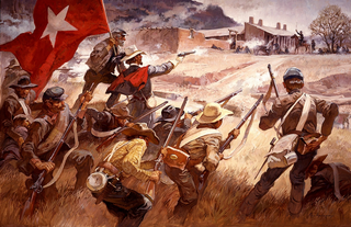
The Battle of Valverde, also known as the Battle of Valverde Ford, was fought from February 20 to 21, 1862, near the town of Val Verde at a ford of the Rio Grande in Union-held New Mexico Territory, in what is today the state of New Mexico. It is considered a major Confederate success in the New Mexico Campaign of the American Civil War, despite the invading force abandoning the field and, eventually, retreating from the territory entirely. The belligerents were Confederate cavalry from Texas and several companies of Arizona militia versus U.S. Army regulars and Union volunteers from northern New Mexico Territory and the Colorado Territory.

The Army of New Mexico, also known as the Sibley Brigade, was a small Confederate field army in the American Civil War. It operated in Confederate Arizona and New Mexico Territory during the New Mexico Campaign in late 1861 and early 1862, before it was transferred to Louisiana. At first the force was tasked with securing Confederate Arizona's forts, most of which were still in Union hands. John R. Baylor had already established the Confederate Territory of Arizona after the First Battle of Mesilla in 1861. Now the goal was to capture the remaining U.S. held forts in Confederate Arizona and to invade New Mexico Territory. The army also hoped to capture the mines of Colorado and California, to secure gold and silver supplies to finance the Confederate war effort. Ultimately, the Confederate plans were thwarted at the Battle of Glorieta Pass.
Fort Fillmore, located at 32°13′30″N 106°42′52″W, was a United States military fortification established by Colonel Edwin Vose Sumner in September 1851 near Mesilla in what is now New Mexico, primarily for the purpose of protecting settlers and traders traveling to California. Early frontier migrants were under constant threat from attack by local Native Americans, and a network of forts was eventually created by the U.S. government to protect and encourage westward expansion. Fort Fillmore was intended to protect a corridor plagued by hostile Apaches, where several migration routes converged between El Paso and Tucson to take advantage of Apache Pass.

The Camino Real de Tierra Adentro, also known as the Silver Route, was a Spanish 2,560-kilometre-long (1,590 mi) road between Mexico City and San Juan Pueblo, New Mexico, that was used from 1598 to 1882. It was the northernmost of the four major "royal roads" that linked Mexico City to its major tributaries during and after the Spanish colonial era.
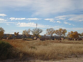
Fort Selden was a United States Army post, occupying the area in what is now Radium Springs, New Mexico. The site was long a campground along the El Camino Real de Tierra Adentro. It was the site of a Confederate Army camp in 1861. The U.S. Army established Fort Selden in 1865 for the purpose of protecting westward settlers from Native American raids, but the post fell into disrepair after the American Civil War. It was ultimately abandoned in 1891, due in large part to the decision to expand Fort Bliss and the lack of any expenditures for repair of the facility.
Polvadera is an unincorporated community and census-designated place in Socorro County in central New Mexico, United States. It is located on the west bank of the Rio Grande, near the mouth of the Rio Salado, and on the western spur of El Camino Real de Tierra Adentro.
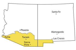
Prior to the adoption of its name for a U.S. state, Arizona was traditionally defined as the region south of the Gila River to the present-day Mexican border, and between the Colorado River and the Rio Grande. It encompasses present-day Southern Arizona and the New Mexico Bootheel plus adjacent parts of Southwestern New Mexico. This area was transferred from Mexico to the United States in the Gadsden Purchase of 1853. Mining and ranching were the primary occupations of traditional Arizona's inhabitants, though growing citrus fruits had long been occurring in Tucson.
The Battle of Canada Alamosa as it was known to the Union Army, or Alamosa as it was known to the Confederates, was a skirmish of the American Civil War on the late evening of September 24 and the morning of September 25, 1861. It was one of several small battles that occurred in Confederate Arizona near the border with Union held New Mexico Territory, this one being the largest.
The Department of New Mexico was a department of the United States Army during the mid-19th century. It was created as the 9th Department, a geographical department, in 1848 following the successful conclusion of the Mexican–American War, and renamed Department of New Mexico in 1853. It had to contend with an invading Confederate force during the New Mexico Campaign of the American Civil War from mid-1861 to early 1862, then with Apache tribes during the remainder of the conflict. It was merged into the Department of California after the end of the war as the District of New Mexico.
Monticello is an unincorporated community located in Sierra County, New Mexico, United States. Monticello is located on Alamosa Creek, 22 miles (35 km) northwest of Truth or Consequences. Monticello has a post office with ZIP code 87939.
Paraje was a populated place along the east bank of the Rio Grande, in Socorro County, New Mexico, United States, now a ghost town. It is located north northeast of the Fra Cristobal Range.
Fort McRae was a Union Army post, established in 1863, then a U.S. Army post from 1866 and closed in 1876, in what is now Sierra County, New Mexico. The post was named for Alexander McRae (1829–1862) a slain hero of the 1862 Battle of Valverde.
Fort Craig - Fort Thorn Wagon Road, was a road ran down along the west bank of the Rio Grande, from a turnoff from the west bank route of the Camino Real de Tierra Adentro to the ford of Valverde, to Fort Craig and on to Fort Thorn. There at or near Fort Thorn were roads south into Texas and west toward Arizona and California.
Contadero is a ghost town along the east bank of the Rio Grande in Socorro County, New Mexico, United States.
San Ygnacio de la Alamosa, also known as Alamosa, is now a ghost town, in Sierra County, New Mexico, United States. San Ygnacio de la Alamosa was founded in 1859 as a native New Mexican colonizing settlement from San Antonio. The site of the new colony was along the west bank of the Rio Grande, 35 miles south of Fort Craig, on the south bank of Alamosa Creek nearby its mouth and confluence with the Rio Grande, in what was then southern Socorro County.


