North Carolina Department of Transportation Ferry Division

Last updated
Logo of the North Carolina Department of Transportation Ferry Division Ncdot ferry.jpg
Logo of the North Carolina Department of Transportation Ferry Division

The North Carolina Department of Transportation Ferry Division is a branch of NCDOT that is responsible for the operation of over two dozen ferry services that transport passengers and vehicles to several islands along the Outer Banks of North Carolina.

Contents

Three other inland, cable ferries the Elwell Ferry, Parker's Ferry, and Sans Souci Ferry continue in operation, under the direct oversight of the North Carolina Department of Transportation, and are not under the supervision of the Ferry Division. An additional coastal ferry servicing Hammocks Beach State Park is operated by the North Carolina Division of Parks and Recreation, and several private companies operate ferry services to sites such as Cape Lookout and Portsmouth Island.

History

Ferries have always played a vital role to the residents and visitors of Eastern North Carolina. The first ferries began in the mid-1920s when Captain J.B. "Toby" Tillett established a tug and barge service across Oregon Inlet along North Carolina's Outer Banks.

In 1934, the North Carolina Highway Commission recognized the importance of this service to residents and began subsidizing Tillett's business. These subsidies kept tolls at an affordable level. In 1942, the Highway Commission began full reimbursement to eliminate the tolls. Tillett was fully subsidized until 1950 when his business was sold to the state.

In 1947, the Commission purchased the ferry operations of T.A. Baum, who operated a route that ran across Croatan Sound and linked Manns Harbor and Roanoke Island. This became the first route of the NC Ferry System.

The logo of the North Carolina Ferry System that appears on all the vessels beneath the name of the vessel on the tower NCDOTFERRY.png
The logo of the North Carolina Ferry System that appears on all the vessels beneath the name of the vessel on the tower

Today

The North Carolina Department of Transportation Ferry Division extends over seven routes and one emergency route, has 22 ferries, and employs over 400 workers. The operations are supported by a full service shipyard at Manns Harbor and 10 support vessels, including dredge, military-style landing craft utility vehicles (LCUs), tugs, and barges. The Ferry Division operates over 200 sailings, with the ferries covering 1,200 miles (1,900 km) each day. The system includes the world's longest fare-free ferry route.

Each year, North Carolina ferries transport nearly 1 million vehicles and more than 2 million passengers across five separate bodies of water - the Currituck and Pamlico sounds and the Cape Fear, Neuse, and Pamlico rivers.

Ferries also carry essential goods to water-locked communities. Many residents depend on the ferries for transportation to school, work, and other needed services.

Types of ferry boats

Hatteras Class

The Hatteras Class ferry, Roanoke, operating between Cherry Branch and Minnesott Beach on the Neuse River. North Carolina Hatteras Class ferry Roanoke.jpg
The Hatteras Class ferry, Roanoke, operating between Cherry Branch and Minnesott Beach on the Neuse River.

The North Carolina Ferry System operates seven Hatteras Class ferries. These Vessels draft only 4 feet, and are designed for the shallow waters and shifting shoals of Eastern North Carolina. Originally designed to carry 150 passengers, these ferries have been downrated to carry only 149 passengers with the introduction of new regulations regarding ferries capable of carrying 150 or more passengers. The Thomas A Baum was sold to a ferry company in the virgin islands. The Roanoke was sold to a ferry company in connecticut

Ferry NameKinnakeetChicamacomicoCape PointOcracokeFrisco
Year Built:19891990199019901990
Vehicle Capacity:3030303030
Passenger Capacity:149149149149149
Gross Ton:280275275275275
Length:150'150'150'150'150'
Breadth:42'42'42'42'42'
Draft:4'4'4'4'4'

River Class

The River Class ferry, Croatoan, operating between Cape Hatteras and Ocracoke Island in the Outer Banks. North Carolina River Class ferry Croatoan.jpg
The River Class ferry, Croatoan, operating between Cape Hatteras and Ocracoke Island in the Outer Banks.

The Ferry System operates ten River Class ferries. These boats are designed for heavy, abusive use, and are double-ended (except the Hunt), meaning they do not have to turn around at the docks. This feature saves time on busy river routes. River class ferries are slowly replacing the older Hatteras class ferries.

Ferry NameDaniel RussellSouthportNeuseFloyd J. LuptonFort FisherCroatoanW. Stanford WhiteHatterasRodantheJames B. HuntSalvo
Year Built:19931996199820002000200320032006201919842022
Vehicle Capacity:4242424040404040402040
Passenger Capacity:300300300300300300300300300149300
Gross Ton:418424374374374376372374388462388
Length:180'180'180'180'180'180'180'180'176'125'176'
Breadth:44'44'44'44'44'44'44'44'46'40'46'
Draft"6'6'6'6'6'5'6"5'6"5'6"6'5'6'

Sound Class

The Sound Class ferry, Cedar Island, operating between Cedar Island and Ocracoke Island in the Outer Banks. North Carolina Sound Class ferry Cedar Island.jpg
The Sound Class ferry, Cedar Island, operating between Cedar Island and Ocracoke Island in the Outer Banks.

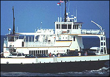
The North Carolina Ferry System operates five Sound Class ferries. These ferries are the largest in the system, able to carry up to 50 cars. These Ferries are designed to withstand the abuse of constantly traversing the shallow, turbulent waters of the Pamlico Sound. The M/V Pamlico has been sold to Cross Sound Ferry of New London, CT. The M/V Pamlico is the sister ship of the M/V Silver Lake.

Ferry NameSilver LakeCarteretCedar IslandSwan QuarterSea Level
Year Built:19651989199420112012
Vehicle Capacity:5050504646
Passenger Capacity:300300300300300
Gross Ton:688771648867867
Length:220'220'220'220'
Breadth:48'50'50'50'50'
Draft"6'6'6"6'6"7'6"7'6"

Routes

M/V Fort Fisher on the Southport-Fort Fisher Ferry route NCDOT Fort Fisher ferry 1.jpg
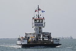
M/V Fort Fisher on the Southport–Fort Fisher Ferry route


Route Currituck Stumpy Point Hatteras Swan Quarter Cedar Island Bayview Cherry Branch Southport
Knotts Island Rodanthe Ocracoke Ocracoke Aurora Minnesott Beach Fort Fisher
State Highway NC 615
NC 615.svg
NC 12 Detour
Detour plate.svg
NC 12.svg
NC 12
NC 12.svg
NC 45
NC 45.svg
NC 12
NC 12.svg
NC 306
NC 306.svg
NC 306
NC 306.svg
NC 211
NC 211.svg
Body of Water Currituck Sound Pamlico Sound Hatteras Inlet Pamlico Sound Pamlico River Neuse River Cape Fear River
Crossing time45 min.1 hr, 45 min.1 hr.2 hrs, 40 min.2 hrs, 15 min30 min.20 min.35 min.
Distance5 miles18 miles4.5 miles27 miles23 miles3.5 miles2.5 miles3.5 miles
FareFreeFreeFreeTollTollFreeFreeToll
Annual Vehicles30,000N/A353,00027,00076,00082,000277,000185,000
Annual Passengers90,000N/A960,00065,000184,000130,000487,000500,000

Emergency route

Tolls

As of April 2023, most of the ferries are free to use. The exceptions are the Cedar Island-Ocracoke, Swan-Quarter-Ocracoke, and Southport-Fort Fisher vehicle ferries. For the two Ocracoke ferries, the fares are $1 for pedestrians, $3 for bicycles, $10 for motorcycles, scooters, ATVs, golf carts, or three-wheeled vehicles, $15 for four wheeled vehicles up to 20 feet, as well as motorcycles with sidecars or trailers, $30 for vehicles 20-40 feet, and $45 for vehicles 40-65 feet. For the Southport-Fort Fisher ferry, the rates are $1 for pedestrians, $2 for bicycles, $3 for motorcycles, scooters, ATVs, golf carts, or three-wheeled vehicles, $7 for four wheeled vehicles up to 20 feet, as well as motorcycles with sidecars or trailer, $14 for vehicles 20-40 feet, and $28 for vehicles 40-65 feet. [4]

Related Research Articles

<span class="mw-page-title-main">Roanoke Island</span> Island in the Outer Banks of North Carolina, United States

Roanoke Island is an island in Dare County, bordered by the Outer Banks of North Carolina. It was named after the historical Roanoke, a Carolina Algonquian people who inhabited the area in the 16th century at the time of English colonization.

<span class="mw-page-title-main">Hyde County, North Carolina</span> County in North Carolina, United States

Hyde County is a county located in the U.S. state of North Carolina. As of the 2020 census, the population was 4,589, making it the second-least populous county in North Carolina. Its county seat is Swan Quarter. The county was created in 1705 as Wickham Precinct. It was renamed Hyde Precinct in 1712 and gained county status in 1739.

<span class="mw-page-title-main">Dare County, North Carolina</span> County in North Carolina, United States

Dare County is the easternmost county in the U.S. state of North Carolina. As of the 2020 census, the population was 36,915. Its county seat is Manteo.

<span class="mw-page-title-main">Ocracoke, North Carolina</span> Census-designated place in North Carolina, United States

Ocracoke is a census-designated place (CDP) and unincorporated town located at the southern end of Ocracoke Island, located entirely within Hyde County, North Carolina, United States. The population was 948 as of the 2010 census. In the 2020 census, the population had dropped to 797 people.

<span class="mw-page-title-main">Pamlico Sound</span> Largest lagoon along the North American East Coast

Pamlico Sound is a large estuarine lagoon in North Carolina. The largest lagoon along the North American East Coast, it extends 80 mi (130 km) long and 15 to 20 miles wide. It is part of a large, interconnected network of similar lagoons that includes Albemarle Sound, Currituck Sound, Croatan Sound, Roanoke Sound, Pamlico Sound, Bogue Sound, Back Sound, and Core Sound known collectively as the Albemarle-Pamlico sound system. With over 3,000 sq. mi. (7,800 km2) of open water the combined estuary is second only in size to 4,479 sq mi (11,600 km2) Chesapeake Bay in the United States.

<span class="mw-page-title-main">Hatteras Island</span> Island in North Carolina, US

Hatteras Island is a barrier island located off the North Carolina coast. Dividing the Atlantic Ocean and the Pamlico Sound, it runs parallel to the coast, forming a bend at Cape Hatteras. It is part of North Carolina's Outer Banks and includes the communities of Rodanthe, Waves, Salvo, Avon, Buxton, Frisco, and Hatteras. It contains the largest part of the Cape Hatteras National Seashore. Prior to European settlement the island was inhabited by Croatoan Native Americans.

<span class="mw-page-title-main">Hatteras, North Carolina</span> Census-designated place in North Carolina, United States of America

Hatteras is an unincorporated village and census-designated place (CDP) in Dare County, North Carolina, United States, on the Outer Banks island of Hatteras, at its extreme southwestern tip. As of the 2010 census it had a population of 504. Immediately to the west of the village of Hatteras is Hatteras Inlet which separates Hatteras Island from the neighboring Ocracoke Island. North Carolina Highway 12 passes through the community linking it to Frisco to the east and Ocracoke to the west.

<span class="mw-page-title-main">Herbert Covington Bonner</span> American politician

Herbert Covington Bonner was a Democratic U.S. Congressman from North Carolina between 1940 and 1965.

<span class="mw-page-title-main">Outer Banks</span> Barrier islands in North Carolina, United States

The Outer Banks are a 200 mi (320 km) string of barrier islands and spits off the coast of North Carolina and southeastern Virginia, on the east coast of the United States. They line most of the North Carolina coastline, separating Currituck Sound, Albemarle Sound, and Pamlico Sound from the Atlantic Ocean. A major tourist destination, the Outer Banks are known for their wide expanse of open beachfront and the Cape Hatteras National Seashore. The seashore and surrounding ecosystem are important biodiversity zones, including beach grasses and shrubland that help maintain the form of the land.

<span class="mw-page-title-main">Cedar Island, North Carolina</span> Island and unincorporated community in North Carolina, US

Cedar Island is an island and unincorporated community in Carteret County, North Carolina, United States. In 2005, the population was estimated to be 350. The ZIP Code for Cedar Island is 28520.

<span class="mw-page-title-main">North Carolina Highway 12</span> State highway in North Carolina, US

North Carolina Highway 12 (NC 12) is a 148.0-mile-long (238.2 km) primary state highway in the U.S. state of North Carolina, linking the peninsulas and islands of the northern Outer Banks. Most sections of NC 12 are two lanes wide, and there are also two North Carolina Ferry System routes which maintain continuity of the route as it traverses the Outer Banks region. NC 12 is part of the Outer Banks Scenic Byway, a National Scenic Byway. The first NC 12 appeared on the 1924 North Carolina Official Map and at its greatest length ran from NC 30 in Pollocksville to NC 48 near Murfreesboro. Over time it was replaced by both U.S. Route 258 (US 258) and NC 58 and ceased to exist in 1958. The current NC 12 first appeared on the 1964 state highway map running from US 158 in Nags Head to Ocracoke. In 1976 NC 12 was extended to US 70 on the mainland and in 1987 was extended north to Corolla.

<span class="mw-page-title-main">North Carolina Highway 615</span> State highway in Currituck County, North Carolina, US

North Carolina Highway 615 (NC 615) is a primary state highway in the U.S. state of North Carolina. It connects Knotts Island with mainland North Carolina via the Currituck–Knotts Island Ferry.

Oregon Inlet is an inlet along North Carolina's Outer Banks. It joins the Pamlico Sound with the Atlantic Ocean and separates Bodie Island from Pea Island, which are connected by the 2.8 mile Marc Basnight Bridge that spans the inlet. As one of the few access points to the ocean along this stretch of coast, Oregon Inlet is a major departure point for charter fishing trips, with a nearby harbor serving as the base for many large boats that travel miles out towards the Gulf Stream almost every day. The inlet is also the location of a U.S. Coast Guard motor lifeboat station.

<span class="mw-page-title-main">North Carolina Department of Transportation</span> Government agency in North Carolina, U.S.

The North Carolina Department of Transportation (NCDOT) is responsible for building, repairing, and operating highways, bridges, and other modes of transportation, including ferries in the U.S. state of North Carolina.

<span class="mw-page-title-main">Effects of Hurricane Isabel in North Carolina</span>

The effects of Hurricane Isabel in North Carolina were widespread, with the heaviest damage in Dare County. The hurricane made landfall in the Outer Banks of North Carolina on September 18. There, storm surge flooding and strong winds damaged thousands of houses. The storm surge produced a 2,000 feet (610 m) wide inlet on Hatteras Island, isolating Hatteras by road for two months. Several locations along North Carolina Highway 12 were partially washed out or covered with debris. Hurricane Isabel produced hurricane-force wind gusts across eastern North Carolina, knocking down trees and power lines. About 700,000 residents lost power due to the storm, although most outages were restored within a few days. The hurricane killed three people in the state – two due to falling trees, and the other a utility worker attempting to restore electricity. Damage in the state totaled $450 million.

<span class="mw-page-title-main">Hatteras Inlet</span> Estuary in North Carolina, U.S.

Hatteras Inlet is an estuary in North Carolina, located along the Outer Banks, separating Hatteras Island and Ocracoke Island. It connects the Atlantic Ocean to the Pamlico Sound. Hatteras Inlet is located entirely within Hyde County.

<span class="mw-page-title-main">North Carolina Highway 306</span> State highway in North Carolina, US

North Carolina Highway 306 (NC 306) is a primary state highway in the U.S. state of North Carolina. The highway provides a link between Havelock, Minnesott Beach, and Grantsboro. The route is primarily rural, and uses two free ferries to cross the Neuse and Pamlico Rivers before reaching NC 92/NC 99 near Gaylord.

<span class="mw-page-title-main">North Carolina Highway 45</span> State highway in North Carolina, US

North Carolina Highway 45 (NC 45) is a primary state highway in the U.S. state of North Carolina. The highway traverses north–south, from Ocracoke to Winton.

<span class="mw-page-title-main">Rodanthe Bridge</span> Bridge in North Carolina, United States

The Rodanthe Bridge, commonly called the Jug Handle Bridge, is a 2.4-mile-long (3.9 km) two-lane "jug handle" trestle bridge in Dare County, North Carolina. The bridge carries North Carolina Highway 12 from Rodanthe to the southern point of Pea Island National Wildlife Refuge by going west into the Pamlico Sound and then parallel an area of the Hatteras Island that is prone to coastal erosion, washouts, and flooding from storms.

References

  1. Nolan, Irene (16 November 2009). "STORM UPDATE... Ferries will run between Stumpy Point and Rodanthe ...WITH VIDEO". The Island Free Press. Retrieved 2 February 2010.
  2. McNichol, Michael (16 November 2009). "NCDOT Ferry Division Activating Emergency Ferry Route Between Stumpy Point and Rodanthe" . Retrieved 2 February 2010.
  3. "State issues CAMA permit for emergency ferry terminal at Stumpy Point". Coastal Management News Releases. NC Division of Coastal Management. 2 April 2002. Retrieved 2 February 2010.
  4. "North Carolina Ferry System 2023 Schedule" (PDF). North Carolina Department of Transportation. Retrieved 17 April 2023.