Related Research Articles
A ferry is a ship, watercraft or amphibious vehicle used to carry passengers, and sometimes vehicles and cargo, across a body of water. A passenger ferry with many stops, such as in Venice, Italy, is sometimes called a water bus or water taxi.

Bertie County is a county located in the northeast area of the U.S. state of North Carolina. As of the 2020 census, the population was 17,934. Its county seat is Windsor. The county was created in 1722 as Bertie Precinct and gained county status in 1739.

A cable ferry is a ferry that is guided across a river or large body of water by cables connected to both shores. Early cable ferries often used either rope or steel chains, with the latter resulting in the alternative name of chain ferry. Both of these were largely replaced by wire cable by the late 19th century.

The Jamestown Ferry is a free automobile and bus ferry service across a navigable portion of the James River in Virginia. It carries State Route 31, connecting Jamestown in James City County with Scotland Wharf in Surry County.

The Runyang Yangtze River Bridge is a large bridge complex that crosses the Yangtze River in Jiangsu Province, China, downstream of Nanjing. The complex consists of two major bridges that link Zhenjiang on the south bank of the river and Yangzhou on the north. The bridge is part of the Yangzhou–Liyang Expressway. Construction of the bridge complex began in October 2000 and was completed ahead of schedule. The bridge cost 5.8 billion Yuan. The complex opened to traffic on April 30, 2005. The total length of the bridge complex is about 35.66 kilometres (22.16 mi). In between the two bridges is the island of Shiyezhou.

Wisemans Ferry is a cable ferry across the Hawkesbury River in New South Wales, Australia. The ferry operates from the eponymous community of Wisemans Ferry on the south bank, to a point on the north bank downstream of the Hawkesbury River's confluence with the Macdonald River, connecting with the old Great North Road. The crossing has remained in use on its current site since 1829, making it the oldest ferry crossing still in operation in New South Wales, and possibly in Australia.

Cedar Island is an island and a small coastal unincorporated community in eastern North Carolina, United States. It is located in Carteret County. It was populated with local Native Americans prior to the arrival of European settlers. It is also the location of the state ferry transportation system dock, where travel can be made across Pamlico Sound to the island and village of Ocracoke in Hyde County. The ZIP Code for Cedar Island is 28520.

The Cape Fear Memorial Bridge is a steel vertical-lift bridge in North Carolina, USA. It carries US 17/US 76/US 421 across the Cape Fear River between Brunswick County and New Hanover County. It also carried U.S. Route 74 until that designation was shifted to the Isabel S. Holmes Bridge. It has a lift span that can be raised 135 feet (41 m). The lift span is 408 feet (124 m) long.
Oregon Inlet is an inlet along North Carolina's Outer Banks. It joins the Pamlico Sound with the Atlantic Ocean and separates Bodie Island from Pea Island, which are connected by the 2.8 mile Marc Basnight Bridge that spans the inlet. As one of the few access points to the ocean along this stretch of coast, Oregon Inlet is a major departure point for charter fishing trips, with a nearby harbor serving as the base for many large boats that travel miles out towards the Gulf Stream almost every day. The inlet is also the location of a U.S. Coast Guard motor lifeboat station.
The North Carolina Department of Transportation Ferry Division is a branch of NCDOT that is responsible for the operation of over two dozen ferry services that transport passengers and vehicles to several islands along the Outer Banks of North Carolina.

The Merrimac Ferry is a cable ferry that crosses the Wisconsin River between Columbia and Sauk Counties in Wisconsin. Its western point is located near the village of Merrimac on State Highway 113 and United States Bicycle Route 30. The eastern point is located in Okee, Wisconsin.

Elwell Ferry is an inland cable ferry which has operated since 1905 on Elwell Ferry Road between NC Highway 53 and NC Highway 87, crossing the Cape Fear River and connecting the communities of Carvers Creek and Kelly in Bladen County, North Carolina.

Parker's Ferry is a cable ferry located on the Meherrin River in Hertford County, North Carolina. The ferry is operated by a contractor for the North Carolina Department of Transportation.

The Oliver Bridge is a bridge across the Saint Louis River. It was constructed in 1910 as a railway bridge by the Interstate Transfer Railway Company, a Wisconsin corporation, under special federal authorization from the 60th United States Congress. A lower deck carrying road traffic was constructed in 1917 It connects the Gary – New Duluth neighborhood in Duluth, Minnesota with the village of Oliver, Wisconsin. The bridge is 1,889 feet (576 m) long and is principally of steel truss construction.

The Pasig River Ferry Service (PRFS) is a public water bus service based in Metro Manila, the Philippines. It is currently the only water-based transportation service in Metro Manila that cruises the length of the Pasig River and Marikina River, passing through the cities of Manila, Makati, Mandaluyong, Pasig, Marikina, and Taguig.

The Wymah Ferry is a cable ferry across the upper reach of Lake Hume, on the Murray River and on the border between the Australian states of New South Wales and Victoria. The ferry crosses from the community of Wymah on the New South Wales side of the river, to Granya, and is approximately 35 kilometres (22 mi) east of Albury.

The Barnston Island Ferry is a ferry that runs across Parson's Channel between Barnston Island and Port Kells, Surrey, in Metro Vancouver.

U.S. Highway 76 (US 76) is a U.S. Highway running from Chattanooga, Tennessee to Wrightsville Beach, North Carolina. In North Carolina the highway runs for 80.4 miles (129.4 km) in the southeastern region of the state. US 76 enters the state from South Carolina south of Fair Bluff in Columbus County. Travelling in an eastward direction, US 76 meets US 74 in Chadbourn. The two highways run concurrently for 50.4 miles (81.1 km) between Chadbourn and Wilmington. US 76 runs concurrently with US 17 along much of its Wilmington routing, until once again meeting US 74. US 76 and US 74 run concurrently for 1.4 miles (2.3 km) until reaching Wrightsville Beach. US 76 reaches its eastern terminus on the south side of Wrightsville Beach, at an intersection with Water Street.
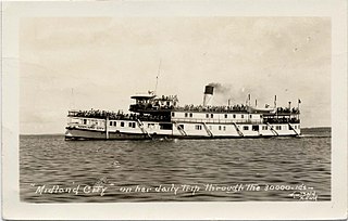
SS Midland City was originally a Canadian side-wheel steamboat that provided passenger and cargo transportation on the Great Lakes from 1871 until 1955. Originally named Maud, then America, she underwent several extensive refits over her 84-year service, and saw several owners. The ship was intentionally run aground and burnt to the waterline in 1955 near the mouth of the Wye River in Midland Bay. The wreck is intact and visible above the water to this day, where it acts as a breakwater for the Wye Heritage Marina and local attraction.
The Upper Arrow Lake Ferry is a ferry across Upper Arrow Lake in the West Kootenay region of southeastern British Columbia. Linking Shelter Bay and Galena Bay, the ferry, part of BC Highway 23, is by road about 52 kilometres (32 mi) south of Revelstoke and 47 kilometres (29 mi) north of Nakusp.
References
- ↑ Adkins, Richard. "The very last ride: DOT cuts mean end to two cable ferries in eastern NC". WRAL News.
- ↑ North Carolina DOT. "Sans Souci Cable Ferry Returns to Service Saturday". North Carolina DOT.