
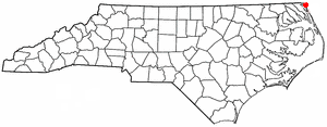
Dare County is the easternmost county in the U.S. state of North Carolina. As of the 2020 census, the population was 36,915. Its county seat is Manteo.

Currituck County is the northeasternmost county in the U.S. state of North Carolina. As of the 2020 census, the population was 28,100. Its county seat is Currituck. The county was formed in 1668 as a precinct of Albemarle County and later gained county status in 1739. The name is "traditionally said to be an indigenous word for wild geese; Coratank." Currituck County is included in the Virginia Beach-Chesapeake, VA-NC Combined Statistical Area. It is in the northeastern section of the state and is bounded by the Atlantic Ocean, Currituck Sound, Camden County, Dare County and the Commonwealth of Virginia. Currituck Court House, mentioned as early as 1755, was the name of the county seat. Today the words "Court House" have been dropped and only Currituck is used as the community name.
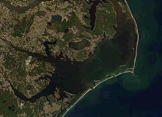
Pamlico Sound is a large estuarine lagoon in North Carolina. The largest lagoon along the North American East Coast, it extends 80 mi (130 km) long and 15 to 20 miles wide. It is part of a large, interconnected network of similar lagoons that includes Albemarle Sound, Currituck Sound, Croatan Sound, Roanoke Sound, Pamlico Sound, Bogue Sound, Back Sound, and Core Sound known collectively as the Albemarle-Pamlico sound system. With over 3,000 sq. mi. (7,800 km2) of open water the combined estuary is second only in size to 4,479 sq mi (11,600 km2) Chesapeake Bay in the United States.
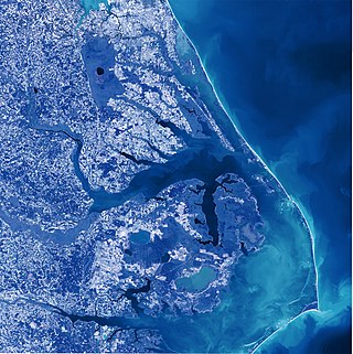
Albemarle Sound is a large estuary on the coast of North Carolina in the United States located at the confluence of a group of rivers, including the Chowan and Roanoke. It is separated from the Atlantic Ocean by the Currituck Banks, a barrier peninsula upon which the town of Kitty Hawk is located, at the eastern edge of the sound, and part of the greater Outer Banks region. Roanoke Island is situated at the southeastern corner of the sound, where it connects to Pamlico Sound. Much of the water in the Albemarle Sound is brackish or fresh, as opposed to the saltwater of the ocean, as a result of river water pouring into the sound.

Corolla is an unincorporated community located in Poplar Branch township, Currituck County, North Carolina, United States, along the northern Outer Banks. It has a permanent population of approximately 500 people; during the summer vacation season, the population surges into the thousands. Corolla is home to the Currituck Beach Lighthouse, one of the seven North Carolina coastal lighthouses.

The Eastern Shore of Virginia is the easternmost region of the Commonwealth of Virginia in the United States. It consists of two counties on the Atlantic coast. It is detached from the mainland of Virginia by the Chesapeake Bay. The 70-mile-long (110 km) region is part of the Delmarva Peninsula. Its population was 45,695 as of 2020.

The Great Dismal Swamp National Wildlife Refuge was created in 1974 to help protect and preserve a portion of the Great Dismal Swamp, a marshy region on the Coastal Plain of southeastern Virginia and northeastern North Carolina between Norfolk, Virginia, and Elizabeth City, North Carolina in the United States. It is located in parts of the independent cities of Chesapeake and Suffolk in Virginia, and the counties of Camden, Gates, and Pasquotank in North Carolina.

Back Bay National Wildlife Refuge in southeastern Virginia is located in the independent city of Virginia Beach. Established in 1938 in an isolated portion of the former Princess Anne County, it is managed by the U.S. Fish & Wildlife Service. The administrative office is located on Sandbridge Road at Sigma between Lago Mar and Sandbridge Beach. The Visitor Contact Center is accessed via Sandpiper Road from the Sandbridge area of Virginia Beach, which is the southernmost area of development on the Atlantic Coast of Virginia.

False Cape State Park is a 4,321-acre (17.49 km2) state park located on the Currituck Banks Peninsula, a one-mile-wide (1.6 km) barrier spit between the Back Bay of the Currituck Sound and the Atlantic Ocean, within the city of Virginia Beach, adjacent to the state border with North Carolina, and just north of Mackay Island National Wildlife Refuge.

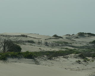
The Outer Banks are a 200 mi (320 km) string of barrier islands and spits off the coast of North Carolina and southeastern Virginia, on the east coast of the United States. They line most of the North Carolina coastline, separating Currituck Sound, Albemarle Sound, and Pamlico Sound from the Atlantic Ocean. A major tourist destination, the Outer Banks are known for their wide expanse of open beachfront and the Cape Hatteras National Seashore. The seashore and surrounding ecosystem are important biodiversity zones, including beach grasses and shrubland that help maintain the form of the land.

Sandbridge, in the U.S. state of Virginia, is a coastal community of Virginia Beach, located along the coastline on the Currituck Banks Peninsula at the northern end of the Outer Banks. The Atlantic Ocean is to the east, the Back Bay of the Currituck Sound is to the west, and the Back Bay National Wildlife Refuge and False Cape State Park lie to the south. To the north, Sandbridge borders the U.S. Navy's Dam Neck facility. Located near the southern end of Sandbridge is Little Island Park, which is managed by the City of Virginia Beach. Sandbridge Beach runs approximately 4.5 miles from north to south along the oceanfront.
Pea Island National Wildlife Refuge is a national wildlife refuge located on North Carolina's Pea Island, a coastal barrier island and part of a chain of islands known as the Outer Banks, adjacent to Cape Hatteras National Seashore. The sanctuary is located 10 miles (16 km) south of Nags Head, North Carolina on NC 12.

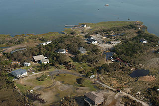
Knotts Island is a marshy island and a small unincorporated community. The island is shared by Currituck County, North Carolina and Virginia Beach, Virginia, United States, bounded by the Currituck Sound, North Landing River, Back Bay, and Knotts Island Bay. Knotts Island is home to Mackay Island National Wildlife Refuge. Knotts Island is accessible overland from Virginia Beach using Princess Anne Road, or by water from the Currituck County mainland; the North Carolina Department of Transportation operates a free ferry between Knotts Island and Currituck on the mainland. The ZIP Code for Knotts Island is 27950.

The Atlantic Flyway is a major north-south flyway for migratory birds in North America. The route generally starts in Greenland, then follows the Atlantic coast of Canada, then south down the Atlantic Coast of the United States to the tropical areas of South America and the Caribbean. Every year, migratory birds travel up and down this route following food sources, heading to breeding grounds, or traveling to overwintering sites.

The Inner Banks is a neologism made up by developers and tourism promoters to describe the inland coastal region of eastern North Carolina. Without historical precedent, the term "Inner Banks" is an early 21st-century construct that is part of an attempt to rebrand the mostly agrarian Coastal Plains east of I-95 as a more attractive region for visitors and retirees.
Carova Beach or Carova is an unincorporated community in Currituck County in the extreme northeastern corner of North Carolina, United States. The community, begun in the 1960s, is found on Currituck Banks, north of Bodie Island, and can be accessed only by boat or by four-wheel drive vehicle. There are no paved roads connecting Carova to the town of Corolla, North Carolina. The neighboring settlement of Sandbridge in Virginia Beach, Virginia, is not accessible by vehicle from Carova. In the 1960s, when development began in Carova, there were plans to construct a paved road from Sandbridge south to Carova through the Back Bay National Wildlife Refuge, but these never materialized. Today, there is a permanent fence from ocean to sound to keep vehicles from crossing and, more importantly, to keep the feral horses from migrating to the Virginia side of the border. To reach Carova, four-wheel drive vehicles must drive north along the beach from Corolla into the community, as access from Virginia is limited to pedestrians and bicyclists.
Bodie Island is a long, narrow barrier peninsula that forms the northernmost portion of the Outer Banks. The land that is most commonly referred to as Bodie Island was at one time a true island, but in 1811 Roanoke Inlet, which had separated it from the Currituck Banks in the north, closed. As a result, the Currituck Banks and Bodie Island are now one contiguous peninsula, joined at the Nags Head area, where the inlet once flowed. Today, either name can be used to refer to the peninsula as a whole, but both portions colloquially retain their historical names.

Currituck National Wildlife Refuge, located on the northern end of North Carolina's Outer Banks, was established in 1984 to preserve and protect the coastal barrier island ecosystem. Refuge lands are managed to provide wintering habitat for waterfowl and to protect endangered species such as piping plover, sea turtles, and seabeach amaranth.
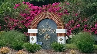
Lago Mar is a neighborhood on the north end of the Currituck Sound in the Princess Anne area of southeastern Virginia Beach, Virginia, United States. The name translated from Spanish to English means "lake" and "sea". It is derived from its proximity to the Atlantic Ocean and Brinson's Inlet Lake, as well as from the neighboring community of Ocean Lakes. The street names within Lago Mar are also of Spanish origin with the notable exception of Atwoodtown, which is what the area was called prior to being renamed in the 1960s.
The Outer Banks are the barrier islands along the east coast of North Carolina in the United States. They are extremely sensitive to environmental hazards, particularly hurricanes. Hazard mitigation plans have been created and are implemented when a hurricane is forecasted to strike the Outer Banks. The goal of the plans is to identify the policies and tools that are needed in order to reduce or eliminate the risk of life and property loss from any event that may occur in the Outer Banks.
