The Gulf of Saint Lawrence is the outlet of the North American Great Lakes via the Saint Lawrence River into the Atlantic Ocean. The gulf is a semi-enclosed sea, covering an area of about 226,000 square kilometres (87,000 sq mi) and containing about 34,500 cubic kilometres (8,300 cu mi) of water, which results in an average depth of 152 metres (499 ft).

Brunswick County is the southernmost county in the U.S. state of North Carolina. As of the 2010 census, the population was 107,431. As its population was only 73,143 in 2000, that makes it one of the fastest growing counties in the state, at a nominal growth rate of about 47% in ten years, with much of the growth centered in the eastern section of the county, the suburbs of Wilmington such as Leland, Belville and Southport. The county seat is Bolivia, which at a population of around 150 people is among the least populous county seats in the state.
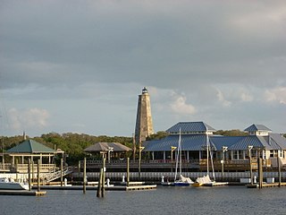
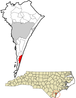
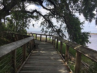
Bald Head Island, historically Smith Island, is a village located on the east side of the Cape Fear River in Brunswick County, North Carolina, United States. Compared to the nearby city of Wilmington to the north, the village of Bald Head Island is small and somewhat remote. It is accessible by ferry from the nearby town of Southport and by 4 wheel-drive vehicle from Fort Fisher to the north. There are few cars on the island; instead, residents drive modified electric golf carts. Bald Head Island is nationally recognized for its sea turtle nesting activity.

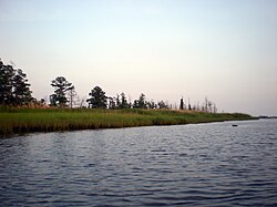
The Northeast Cape Fear River is a blackwater river tributary of the Cape Fear River, approximately 130 mi (209 km) long, in southeastern North Carolina in the United States.
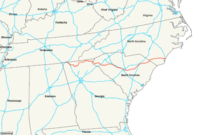
U.S. Route 76 is an east–west U.S. highway that travels for approximately 548 miles (882 km) from Chattanooga, Tennessee, to Wrightsville Beach, North Carolina.

Catoctin Creek is a 27.9-mile-long (44.9 km) tributary of the Potomac River in Frederick County, Maryland, USA. Its source is formed in the Myersville, Maryland area and flows directly south for the entire length of the stream. Catoctin Creek enters the Potomac River east of Brunswick. The stream flows through Catoctin Creek Park.

Beech Creek is a 27.3-mile-long (43.9 km) tributary of Bald Eagle Creek in Centre and Clinton counties, in Pennsylvania in the United States.
Little Catoctin Creek is an 8.5-mile-long (13.7 km) tributary of the Potomac River in Frederick County, Maryland. The creek starts south of Burkittsville and flows to the southeast, passing north of Brunswick before emptying into the Potomac west of Lander.

Cape Fear is a coastal plain and Tidewater region of North Carolina centered about the city of Wilmington. The region takes its name from the adjacent Cape Fear headland, as does the Cape Fear River which flows through the region and empties into the Atlantic Ocean near the cape. Much of the region's populated areas are found along the Atlantic beaches and the Atlantic Intracoastal Waterway, while the rural areas are dominated by farms and swampland like that of the Green Swamp. The general area can be also identified by the titles "Lower Cape Fear", "Wilmington Metropolitan Area", "Southeastern North Carolina", and "Azalea Coast". The latter name is derived from the North Carolina Azalea Festival held annually in Wilmington. Municipalities in the area belong to the Cape Fear Council of Governments.
Pleasure Island is a coastal barrier island in Southeastern North Carolina, USA just south of the City of Wilmington. Pleasure Island is located within Federal Point Township, in New Hanover County. The coastal resort towns of Carolina Beach and Kure Beach, as well as the annexed communities of Wilmington Beach and Hanby Beach are located on the island. The southern end of Pleasure Island was separated from Bald Head Island by Corncake Inlet until the inlet was shoaled and closed in 1998 by Hurricane Bonnie; thus Pleasure Island and Bald Head Island are no longer separate islands.

Fort Anderson is a mid 19th century earthen fort in the lower Cape Fear Region of North Carolina, located over the ruins of the colonial town of Brunswick in Brunswick County. It was used as a Confederate Fort during the American Civil War. The fort was pivotal in protecting the Cape Fear River inlets and Wilmington upstream. Earthen batteries comprise the fort and were used as platforms and shields for the Confederate cannons. Beneath some of the earthworks were "bombproofs," shelters used by troops during enemy bombardment. The Confederacy decided to build forts around the Cape Fear River to protect the port of Wilmington from the Union blockade. During the Civil War, blockade runners brought supplies such as iron, guns, and ammunition to the Confederacy. The purpose of the fort was to hinder movement of Union ships, and to serve as a dropping off point for blockade runners fortunate enough to make it up the mouth of the Cape Fear River. Fort Anderson was built on the ruins of Brunswick Town and was originally named Fort St. Philip, after the ruins of the Revolutionary period church nearby. The name was changed to honor Col. George B. Anderson.
Brunswick Town was a prominent town in colonial North Carolina. It was the first successful European settlement in the Cape Fear region, a major British port in the 18th century, and home to two provincial governors. Brunswick Town lasted 50 years (1726–1776) until it was raided by the British Army during the American Revolutionary War and never rebuilt. During the American Civil War, 86 years after the town was abandoned, a large portion of the town was covered by earthworks for the construction of Fort Anderson.
Wy'east Falls is a waterfall on a small tributary of Eagle Creek in Hood River County, Oregon, U.S.
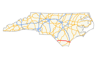
U.S. Highway 76 (US 76) is an east–west road in North Carolina running from the South Carolina state line to Wrightsville Beach. US 76 runs concurrently with US 74 for 52 miles (84 km) of the entire route in North Carolina. US 76 was first designated in North Carolina between late 1934 and 1935.
The Buffalo River is a 4.5-mile-long (7.2 km) tidal river northwest of Brunswick, Georgia. It is part of the Brunswick River network of tidal channels along the Atlantic coast of the U.S. state of Georgia.

The Fish River is a 69.9-mile-long (112.5 km) river in northern Maine in the United States. It is a tributary of the Saint John River, which flows to the Bay of Fundy in New Brunswick, Canada.

Military Ocean Terminal Sunny Point (MOTSU) is one of the largest military terminals in the world. It serves as a transfer point between rail, trucks, and ships for the import and export of weapons, ammunition, explosives and military equipment for United States Army. The 596th Transportation Brigade, United States Army, operates the terminal.

The Poesten Kill is a 26.2-mile-long (42.2 km) creek in upstate New York located entirely in Rensselaer County, which flows westerly from its source at Dyken Pond in the town of Berlin to its mouth at the Hudson River in the city of Troy. It has been used historically as a source of water for local inhabitants and farmers and became even more important as a source of water power during the Industrial Revolution, during which many mills and factories sprung up along its banks.