Red Oak, North Carolina

Last updated

Red Oak, North Carolina
Red Oak UMC from southwest.jpg
Methodist church
Nash County North Carolina incorporated and unincorporated areas Red Oak highlighted.svg
Location in Nash County and the state of North Carolina.
Coordinates: 36°1′53″N77°54′6″W / 36.03139°N 77.90167°W / 36.03139; -77.90167
Country United States
State North Carolina
County Nash
Area
[1]
  Total19.54 sq mi (50.61 km2)
  Land19.53 sq mi (50.58 km2)
  Water0.01 sq mi (0.02 km2)
Elevation
[2]
203 ft (62 m)
Population
 (2020)
  Total3,342
  Density171.11/sq mi (66.07/km2)
Time zone UTC-5 (Eastern (EST))
  Summer (DST) UTC-4 (EDT)
ZIP code
27868
Area code 252
FIPS code 37-55640 [3]
GNIS feature ID1022197 [2]

Red Oak is a town in Nash County, North Carolina, United States. It is part of the Rocky Mount, North Carolina Metropolitan Statistical Area. The population was 3,430 in 2010.

Contents

History

Black Jack and the Red Oak Community House are listed on the National Register of Historic Places. [4]

Geography

According to the United States Census Bureau, the town has a total area of 19.5 square miles (51 km2), of which 19.5 square miles (51 km2) is land and 0.05% is water.

Demographics

Historical population
CensusPop.Note
1970 359
1980 314−12.5%
1990 280−10.8%
2000 2,723872.5%
2010 3,43026.0%
2020 3,342−2.6%
U.S. Decennial Census [5]

2020 census

Red Oak racial composition [6]
RaceNumberPercentage
White (non-Hispanic)2,71781.3%
Black or African American (non-Hispanic)42212.63%
Native American 210.63%
Asian 110.33%
Other/Mixed 922.75%
Hispanic or Latino 792.36%

As of the 2020 United States census, there were 3,342 people, 1,433 households, and 1,133 families residing in the town.

2000 census

As of the census [3] of 2000, there were 2,723 people, 984 households, and 821 families residing in the town. The population density was 139.7 inhabitants per square mile (53.9/km2). There were 1,030 housing units at an average density of 52.8 per square mile (20.4/km2). The racial makeup of the town was 90.67% White, 8.04% African American, 0.07% Native American, 0.26% Asian, 0.33% from other races, and 0.62% from two or more races. Hispanic or Latino of any race were 1.32% of the population.

There were 984 households, out of which 38.3% had children under the age of 18 living with them, 74.0% were married couples living together, 6.6% had a female householder with no husband present, and 16.5% were non-families. 14.6% of all households were made up of individuals, and 6.5% had someone living alone who was 65 years of age or older. The average household size was 2.77 and the average family size was 3.06.

In the town, the population was spread out, with 26.1% under the age of 18, 6.2% from 18 to 24, 28.8% from 25 to 44, 28.7% from 45 to 64, and 10.2% who were 65 years of age or older. The median age was 39 years. For every 100 females, there were 98.3 males. For every 100 females age 18 and over, there were 94.3 males.

The median income for a household in the town was $54,958, and the median income for a family was $61,406. Males had a median income of $40,718 versus $26,091 for females. The per capita income for the town was $22,616. About 5.7% of families and 6.7% of the population were below the poverty line, including 4.9% of those under age 18 and 16.6% of those age 65 or over.

Related Research Articles

<span class="mw-page-title-main">Wales, Maine</span> Town in the state of Maine, United States

Wales is a town in Androscoggin County, Maine, United States. The population was 1,608 at the 2020 census. It is included in both the Lewiston-Auburn, Maine Metropolitan Statistical Area and the Lewiston-Auburn, Maine Metropolitan New England City and Town Area.

<span class="mw-page-title-main">Linneus, Maine</span> Town in the state of Maine, United States

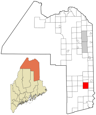
Linneus is a town in Aroostook County, Maine, United States. The population was 947 at the 2020 census. It is named after Carl Linnaeus.

<span class="mw-page-title-main">Mount Desert, Maine</span> Town in the state of Maine, United States

Mount Desert is a town on Mount Desert Island in Hancock County, Maine, United States. The population was 2,146 at the 2020 census. Incorporated in 1789, the town currently encompasses the villages of Otter Creek, Seal Harbor, Northeast Harbor, Somesville, Hall Quarry, and Pretty Marsh.

<span class="mw-page-title-main">Biltmore Forest, North Carolina</span> Town in North Carolina, United States

Biltmore Forest is a town in Buncombe County, North Carolina, United States. The population was 1,343 in 2010. It is part of the Asheville Metropolitan Statistical Area. Biltmore Forest is the second-wealthiest town in North Carolina by per capita income at $85,044.

<span class="mw-page-title-main">Cedar Point, North Carolina</span> Town in North Carolina, United States

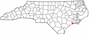
Cedar Point is a town in Carteret County, North Carolina, United States. The population was 1,297 in 2010.

<span class="mw-page-title-main">Peletier, North Carolina</span> Town in North Carolina, United States

Peletier is a town in Carteret County, North Carolina, United States. The population was 644 at the 2010 census.

Light Oak is an unincorporated area and census-designated place (CDP) in Cleveland County, North Carolina, United States. The population was 691 at the 2010 census.

<span class="mw-page-title-main">Forest Oaks, North Carolina</span> Census-designated place in North Carolina, United States

Forest Oaks is a census-designated place (CDP) in Guilford County, North Carolina, United States. The population was 3,890 as of the 2010 census, up from 3,241 in 2000.

<span class="mw-page-title-main">Oak Ridge, North Carolina</span> Town in North Carolina, United States

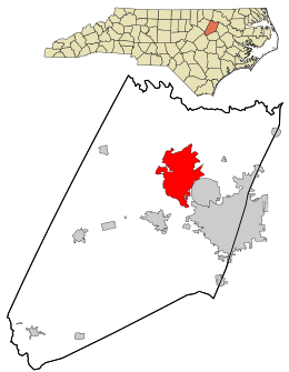
Oak Ridge is a town in northwestern Guilford County, North Carolina, United States. As of the census of 2020, the town had a population of 7,474. Oak Ridge is 15 miles (24 km) northwest of the center of Greensboro, North Carolina's third-most populous city. Oak Ridge is a part of the Piedmont Triad urban area.

<span class="mw-page-title-main">Pleasant Garden, North Carolina</span> Town in North Carolina, United States

Pleasant Garden is a town in Guilford County, North Carolina, United States.

<span class="mw-page-title-main">Four Oaks, North Carolina</span> Town in North Carolina, United States

Four Oaks is a town in Johnston County, North Carolina, United States. As of the 2010 census it had a population of 1,921, up from 1,424 in 2000.

<span class="mw-page-title-main">Maysville, North Carolina</span> Town in North Carolina, United States

Maysville is a town in Jones County, North Carolina, United States. The population was 818 at the 2020 census. It is part of the New Bern, North Carolina Metropolitan Statistical Area. This town was home to former MLB left fielder Louie Meadows.

<span class="mw-page-title-main">Oak City, North Carolina</span> Town in North Carolina, United States

Oak City, formerly known as Goose Nest, is a town in Martin County, North Carolina, United States. The population was 266 at the 2020 census.

Newton Grove is a town in Sampson County, North Carolina, United States. It was chartered in 1879. The population was 585 at the 2020 census.

<span class="mw-page-title-main">West Salem Township, Pennsylvania</span> Township in Pennsylvania, United States

West Salem Township is a township in Mercer County, Pennsylvania, United States. The population was 3,220 at the 2020 census, a decrease from 3,538 in 2010.

Seven Oaks is a census-designated place (CDP) in Lexington County, South Carolina, United States, 8 miles (13 km) northwest of downtown Columbia, the state capital. The population of the CDP was 15,144 at the 2010 census. It is part of the Columbia Metropolitan Statistical Area.

<span class="mw-page-title-main">Oak Trail Shores, Texas</span> Census-designated place in Texas, United States

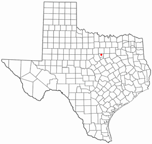
Oak Trail Shores is an unincorporated community and census-designated place (CDP) in Hood County, Texas, United States. Its population was 2,755 at the 2010 census. It is part of the Granbury micropolitan area as well as the Dallas–Fort Worth metroplex.

<span class="mw-page-title-main">Polar, Wisconsin</span> Town in Wisconsin, United States

Polar is a town in Langlade County, Wisconsin, United States. The population was 984 at the 2010 census.

<span class="mw-page-title-main">Stockton, Wisconsin</span> Town in Wisconsin, United States

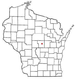
Stockton is a town in Portage County, Wisconsin, United States. The population was 2,896 at the 2000 census. The unincorporated communities of Arnott, Custer, Fancher, Esker, and Stockton are located in Stockton.

<span class="mw-page-title-main">Weddington, North Carolina</span> Town in North Carolina, United States

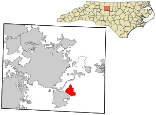
Weddington is a suburban town in Union County, North Carolina, United States. The population was 9,459 at the 2010 census. It is a suburb in the Charlotte metropolitan area. The current mayor of Weddington is Jim Bell.

References

  1. "ArcGIS REST Services Directory". United States Census Bureau. Retrieved September 20, 2022.
  2. 1 2 U.S. Geological Survey Geographic Names Information System: Red Oak, North Carolina
  3. 1 2 "U.S. Census website". United States Census Bureau . Retrieved January 31, 2008.
  4. "National Register Information System". National Register of Historic Places . National Park Service. July 9, 2010.
  5. "Census of Population and Housing". Census.gov. Retrieved June 4, 2015.
  6. "Explore Census Data". data.census.gov. Retrieved December 24, 2021.