Five Points, North Carolina

Last updated

Five Points, North Carolina
NCMap-doton-FivePoints.PNG
Location of Five Points, North Carolina
Coordinates: 35°00′44″N79°22′48″W / 35.01222°N 79.38000°W / 35.01222; -79.38000
Country United States
State North Carolina
County Hoke
Area
[1]
  Total8.28 sq mi (21.45 km2)
  Land8.28 sq mi (21.45 km2)
  Water0.00 sq mi (0.00 km2)
Elevation
[2]
364 ft (111 m)
Population
 (2020)
  Total961
  Density116.06/sq mi (44.81/km2)
Time zone UTC-5 (Eastern (EST))
  Summer (DST) UTC-4 (EDT)
ZIP code
28376 [3]
Area codes 910, 472
FIPS code 37-23520 [4]
GNIS feature ID2402486 [2]

Five Points is a census-designated place (CDP) in Hoke County, North Carolina, United States. The population was 689 at the 2010 census. [5]

Contents

Geography

Five Points is located in western Hoke County. The original "Five Points" is the intersection of Calloway Road, Montrose Road, and N. Horace Walters Road, 8 miles (13 km) northwest of Raeford, the Hoke county seat. The Five Points CDP extends east as far as North Carolina Highway 211 and west to Pendergrass Road and Mountain Creek.

According to the United States Census Bureau, the CDP has a total area of 8.3 square miles (21.4 km2), all of it land. The community is drained by Mountain Creek, Little Creek, and Buffalo Creek, all southwest-flowing tributaries of Drowning Creek, the upstream name of the Lumber River.

Demographics

Historical population
CensusPop.Note
2020 961
U.S. Decennial Census [6]

As of the census [4] of 2000, there were 306 people, 113 households, and 91 families residing in the CDP. The population density was 57.2 inhabitants per square mile (22.1/km2). There were 125 housing units at an average density of 23.4/sq mi (9.0/km2). The racial makeup of the CDP was 59.15% White, 34.97% African American, 5.56% Native American, 0.33% from other races. Hispanic or Latino of any race were 3.27% of the population.

There were 113 households, out of which 38.1% had children under the age of 18 living with them, 50.4% were married couples living together, 21.2% had a female householder with no husband present, and 18.6% were non-families. 15.9% of all households were made up of individuals, and 5.3% had someone living alone who was 65 years of age or older. The average household size was 2.71 and the average family size was 2.91.

In the CDP, the population was spread out, with 27.5% under the age of 18, 12.7% from 18 to 24, 29.1% from 25 to 44, 20.6% from 45 to 64, and 10.1% who were 65 years of age or older. The median age was 32 years. For every 100 females, there were 104.0 males. For every 100 females age 18 and over, there were 93.0 males.

The median income for a household in the CDP was $51,313, and the median income for a family was $45,729. Males had a median income of $14,796 versus $18,958 for females. The per capita income for the CDP was $14,872. About 7.0% of families and 9.9% of the population were below the poverty line, including 19.0% of those under the age of 18 and none of those 65 or over.

Related Research Articles

<span class="mw-page-title-main">Trapper Creek, Alaska</span> Census-designated place in Alaska, United States

Trapper Creek is a census-designated place (CDP) in Matanuska-Susitna Borough, Alaska, United States. It is part of the Anchorage Metropolitan Area and is known as the southern gateway to Denali State Park. According to the 2020 census the population of Trapper Creek was 499.

<span class="mw-page-title-main">Evans, Georgia</span> Census-designated place in Georgia, United States

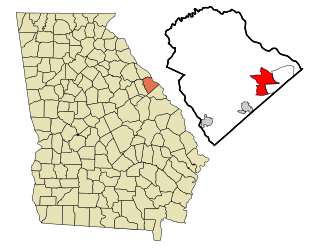
Evans is a census-designated place (CDP) in Columbia County, Georgia, United States. It is a suburb of Augusta and is part of the Augusta metropolitan area. The population was 29,011 at the 2010 census, up from 17,727 at the 2000 census.

<span class="mw-page-title-main">Avery Creek, North Carolina</span> Census-designated place in North Carolina, United States

Avery Creek is a census-designated place (CDP) in Buncombe County, North Carolina, United States. The population was 1,950 at the 2010 census. It is part of the Asheville Metropolitan Statistical Area.

<span class="mw-page-title-main">Bent Creek, Buncombe County, North Carolina</span> Census-designated place in North Carolina, United States

Bent Creek is a census-designated place (CDP) in Buncombe County, North Carolina, United States. The population was 1,287 at the 2010 census. The Bent Creek area has mountain bike trails within the Pisgah National Forest.

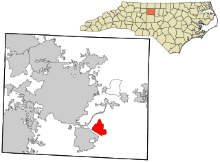
Brices Creek is an unincorporated area and census-designated place (CDP) in Craven County, North Carolina, United States. The population was 3,073 at the 2010 census. It is part of the New Bern, North Carolina Metropolitan Statistical Area.

<span class="mw-page-title-main">Fairfield Harbour, North Carolina</span> Census-designated place in North Carolina, United States

Fairfield Harbour is an unincorporated community and census-designated place (CDP) in Craven County, North Carolina, United States. The population was 2,952 at the 2010 census, up from 1,983 in 2000. It is part of the New Bern, North Carolina Metropolitan Statistical Area.

<span class="mw-page-title-main">Forest Oaks, North Carolina</span> Census-designated place in North Carolina, United States

Forest Oaks is a census-designated place (CDP) in Guilford County, North Carolina, United States. The population was 3,890 as of the 2010 census, up from 3,241 in 2000.

<span class="mw-page-title-main">McLeansville, North Carolina</span> Census-designated place in North Carolina, United States

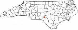
McLeansville is an unincorporated community and census-designated place (CDP) in Guilford County, North Carolina, United States. The population was 1,021 at the 2010 census.

<span class="mw-page-title-main">Buies Creek, North Carolina</span> Census-designated place in North Carolina, United States

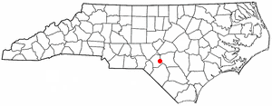
Buies Creek is a census-designated place (CDP) located in the Neills Creek Township of Harnett County, North Carolina, United States. It is the home of Campbell University. The population was 3,253 at the 2020 census, up from 2,942 in 2010. Buies Creek is a part of the Dunn Micropolitan Area, which is also a part of the greater Raleigh–Durham–Cary Combined Statistical Area (CSA) as defined by the United States Census Bureau.

<span class="mw-page-title-main">Mountain Home, North Carolina</span> Census-designated place in North Carolina, United States

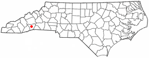
Mountain Home is an unincorporated community and census-designated place (CDP) in Henderson County, North Carolina, United States. The population was 3,622 at the 2010 census, up from 2,169 in 2000. It is part of the Asheville Metropolitan Statistical Area.

<span class="mw-page-title-main">Ashley Heights, North Carolina</span> Census-designated place in North Carolina, United States

Ashley Heights is an unincorporated community and census-designated place (CDP) in Hoke County, North Carolina, United States. The population was 380 at the 2010 census.

<span class="mw-page-title-main">Bowmore, North Carolina</span> Census-designated place in North Carolina, United States

Bowmore is an unincorporated community and census-designated place (CDP) in Hoke County, North Carolina, United States. The population was 103 at the 2010 census.

<span class="mw-page-title-main">Dundarrach, North Carolina</span> Census-designated place in North Carolina, United States

Dundarrach is a census-designated place (CDP) in Hoke County, North Carolina, United States. At the 2010 census, the population was 41.

<span class="mw-page-title-main">Rockfish, North Carolina</span> Census-designated place in North Carolina, United States

Rockfish is a census-designated place (CDP) in Hoke County, North Carolina, United States. The population was 3,298 at the 2010 census, up from 2,353 at the 2000 census.

<span class="mw-page-title-main">Silver City, North Carolina</span> Census-designated place in North Carolina, United States

Silver City is an unincorporated area and census-designated place (CDP) in Hoke County, North Carolina in the United States. The population was 882 at the 2010 census, down from 1,146 at the 2000 census.

<span class="mw-page-title-main">Lowesville, North Carolina</span> Census-designated place in North Carolina, United States

Lowesville is a census-designated place (CDP) in Lincoln County, North Carolina, United States. The population was 2,945 at the 2010 census, up from 1,440 in 2000.

Flint Creek is an unincorporated area and census-designated place (CDP) in Delaware County, Oklahoma, United States. The population was 732 at the 2010 census, up from 580 in 2000.

Elgin is an unincorporated community and census-designated place (CDP) in Lancaster County, South Carolina, United States. The population was 2,607 at the 2010 census.

<span class="mw-page-title-main">Mountville, South Carolina</span> Census-designated place in South Carolina, United States

Mountville is an unincorporated community and census-designated place (CDP) in Laurens County, South Carolina, United States. The population was 108 at the 2010 census, down from 130 at the 2000 census. It is part of the Greenville–Mauldin–Easley Metropolitan Statistical Area.

<span class="mw-page-title-main">Red Bank, South Carolina</span> Census-designated place in South Carolina, United States

Red Bank is an unincorporated community and census-designated place (CDP) in Lexington County, South Carolina, United States. The population was 9,617 at the 2010 census, up from 8,811 at the 2000 census. It is part of the Columbia, South Carolina Metropolitan Statistical Area.

References

  1. "ArcGIS REST Services Directory". United States Census Bureau. Retrieved September 20, 2022.
  2. 1 2 U.S. Geological Survey Geographic Names Information System: Five Points, North Carolina
  3. "Five Points NC ZIP Code". zipdatamaps.com. 2023. Retrieved February 17, 2023.
  4. 1 2 "U.S. Census website". United States Census Bureau . Retrieved January 31, 2008.
  5. "Geographic Identifiers: 2010 Census Summary File 1 (G001): Five Points CDP, North Carolina". American Factfinder. U.S. Census Bureau. Archived from the original on February 13, 2020. Retrieved December 21, 2017.
  6. "Census of Population and Housing". Census.gov. Retrieved June 4, 2016.