
Caldwell County is a county in the U.S. state of North Carolina. It is located in the foothills of the Blue Ridge Mountains. As of the 2020 census, the population was 80,652. Its county seat is Lenoir. Caldwell County is part of the Hickory-Lenoir-Morganton, NC Metropolitan Statistical Area.

Burke County is a county located in the U.S. state of North Carolina. As of the 2020 census, its population was 87,570. Its county seat is Morganton.

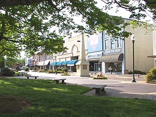
Morganton is a city in and county seat of Burke County, North Carolina, United States. The population was 17,474 at the 2020 census. Morganton is approximately 75 miles (121 km) northwest of Charlotte and 57 miles (92 km) east of Asheville.

Lenoir is a city in and the county seat of Caldwell County, North Carolina, United States. The population was 18,263 at the 2020 census. Lenoir is located in the foothills of the Blue Ridge Mountains. To the northeast are the Brushy Mountains, a spur of the Blue Ridge Mountains. Hibriten Mountain, located just east of the city limits, marks the western end of the Brushy Mountains range.
Hickory is a city in western North Carolina primarily located in Catawba County. The 25th most populous city in the state, it is located approximately 60 miles (97 km) northwest of Charlotte.

Augusta Regional Airport is a city-owned public airport six miles (11 km) south of Augusta, in Richmond County, Georgia, United States.

Grand Forks International Airport is a public airport five miles (8 km) northwest of Grand Forks, in Grand Forks County, North Dakota, United States. GFK has no scheduled passenger flights out of the country but has an "international" title because it has customs service for arrivals from Canada and other countries.

Double Eagle II Airport is a public airport located seven miles (11 km) northwest of the central business district of Albuquerque, a city in Bernalillo County, New Mexico, United States. It is owned by the City of Albuquerque.

Greater Cumberland Regional Airport is a public airport in the town of Wiley Ford in Mineral County, West Virginia, United States. It is two miles (3 km) south of Cumberland in Allegany County, Maryland. Although the airport is in the Potomac Highlands of West Virginia, the FAA lists this as a Maryland airport. No major airlines fly here, with the nearest major airport being Johnstown–Cambria County Airport about 66 miles (106 km) away in Johnstown, Pennsylvania, as well as Hagerstown Regional Airport in Hagerstown, Maryland. In addition, it is situated in close proximity to Interstate 68 and U.S. Route 220, which both run through the nearby city of Cumberland.

Kinston Regional Jetport, also known as Stallings Field, is a public airport located three miles (5 km) northwest of the central business district of Kinston, a city in Lenoir County, North Carolina. The airport has a single runway that is one of the longest in the southeastern United States. It is mostly used for general aviation.
Oakland/Troy Airport is a county-owned public-use airport located two miles (3.2 km) east of the central business district of Troy, a city in Oakland County, Michigan, United States. It is included in the Federal Aviation Administration (FAA) National Plan of Integrated Airport Systems for 2017–2021, in which it is categorized as a regional reliever airport facility.
Glendale Regional Airport is a city-owned, public-use airport located 7 miles west of the central business district of Glendale, a city in Maricopa County, Arizona, United States. It is included in the National Plan of Integrated Airport Systems for 2011–2015, which categorized it as a general aviation reliever airport.

North Carolina Highway 18 (NC 18) is a primary state highway in the U.S. state of North Carolina. Traveling north–south through the Foothills region, it connects the cities of Shelby, Morganton, Lenoir, Wilkesboro and North Wilkesboro.
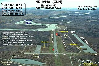
Nenana Municipal Airport is a city-owned public-use airport located one mile (1.6 km) south of the central business district of Nenana, a city in the Yukon-Koyukuk Census Area of the U.S. state of Alaska.
Michael J. Smith Field is a public airport located one mile (2 km) north of the central business district of Beaufort and northeast of Morehead City, in Carteret County, North Carolina, United States. It is owned by the Beaufort-Morehead City Airport Authority.

Boulder Municipal Airport is a public airport located 3 miles (4.8 km) northeast of the central business district of Boulder, a city in Boulder County, Colorado, United States. It is owned by the City of Boulder and used almost exclusively for general aviation. Its location in the foothills of the Rockies east of the continental divide gives excellent conditions for soaring, and there is extensive gliding activity. It is the base of the Soaring Society of Boulder.

Jefferson City Memorial Airport is two miles (3 km) northeast of Jefferson City, in Callaway County, Missouri. It is owned by the City of Jefferson City.
The Hickory–Lenoir–Morganton, NC Metropolitan Statistical Area, as defined by the United States Census Bureau, is an area consisting of four counties, Catawba, Burke, Caldwell, Alexander. It is located in the Catawba Valley region of western North Carolina. Local residents often refer to the area as The Unifour, although this name is largely unknown outside of the region.
Indianapolis Regional Airport is a public use airport in Hancock County, Indiana, United States. Owned by Indianapolis Airport Authority, it is 12 nautical miles (22 km) east of the central business district of Indianapolis. The airport is also 7 nautical miles (13 km) northwest of Greenfield and 3 nautical miles (6 km) southwest of McCordsville. It was known as Mount Comfort Airport until March 2011.

The Charlotte metropolitan area, sometimes referred to as Metrolina, is a metropolitan area of the U.S. states of North and South Carolina, containing the city of Charlotte, North Carolina. The metropolitan area also includes the cities of Gastonia, Concord, Huntersville, and Rock Hill as well as the large suburban area in the counties surrounding Mecklenburg County, which is at the center of the metro area. Located in the Piedmont, it is the largest metropolitan area in the Carolinas, and the fourth largest in the Southeastern United States. The Charlotte metropolitan area is one of the fastest growing metropolitan areas in the United States.


