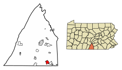
The population within the borough limits was 10,951 at the 2020 census.[2] When combined with the surrounding Washington and Quincy Townships, the population of greater Waynesboro is 31,166. The Waynesboro Area School District serves a resident population of 32,386, according to 2010 federal census data.
The region around Antietam Creek had been home to Native Americans for thousands of years prior to settlement by Anglo-Europeans in the mid-18th century. Beginning in 1751, a certain John Wallace obtained several warrants for the land on which the center of the town now stands. In 1797, John Wallace, a son of the original Scottish settler, laid out the town of Waynesburg in Franklin (formerly Cumberland) County, Pennsylvania (USA).[3] When incorporated in 1831, the borough was given the name "Waynesboro". It is one of several dozen towns, cities, and counties named after General Anthony Wayne, a hero of the American Revolution.
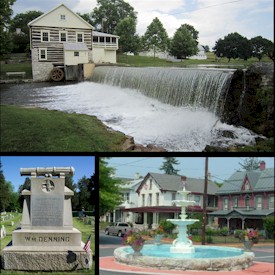
Numerous stone grain mills are in the area: Welty's Mill, Shank's Mill, Hopewell Roller Mill and others. Most of them still standing and in use.
By the early years of the 20th century, Waynesboro had become an industrial town. It was known for the manufacture of engines, boilers, grinders, threshers, boring machines, bolt cutters, wood and iron workers' vises, nut facers, etc. There were also foundries and machine shops and manufacturers of lumber products. Local companies included Frick Company, Geiser Manufacturing, Waynesboro Knitting Mill, Connie's Sportwear, Freeman's Shoes, Landis Machine Company, and Landis Tool Company. In 1900, 5,396 people lived in the town; in 1910, 7,199 people; and in 1940, 10,231 people (notably more than in the year 2000 census).
Amenities
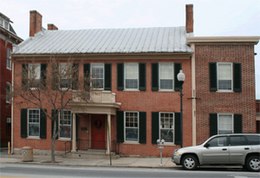
Waynesboro is home to Renfrew Museum and Park,[4] a historical museum depicting 18th-century farm life. It is named after two young sisters who reputedly died there in 1764 during a Native American attack.
As of the census[9] of 2010, there were 10,568 people, 4,512 households, and 2,740 families residing in the borough. The population density was 3,108.2 inhabitants per square mile (1,200.1/km2). There were 4,969 housing units at an average density of 1,461.4 per square mile (564.2/km2). The racial makeup of the borough was 90.6% White, 2.9% African American, 0.3% Native American, 0.6% Asian, 0.0% Pacific Islander, 0.1% from other races, and 1.9% from two or more races. Hispanic or Latino of any race were 3.7% of the population.
There were 4,512 households, out of which 27.4% had children under the age of 18 living with them, 40.7% were married couples living together, 14.1% had a female householder with no husband present, and 39.3% were non-families. 32.7% of all households were made up of individuals, and 12.7% had someone living alone who was 65 years of age or older. The average household size was 2.33 and the average family size was 2.91.
In the borough, the population was spread out, with 23.4% under the age of 18, 9.8% from 18 to 24, 27.7% from 25 to 44, 24.2% from 45 to 64, and 15.1% who were 65 years of age or older. The median age was 36.6 years. For every 100 females there were 91.8 males. For every 100 females age 18 and over, there were 88.8 males.
The median income for a household in the borough was $41,155, and the median income for a family was $48,379. Males had a median income of $35,754 versus $30,872 for females. The per capita income for the borough was $21,749. About 7.0% of families and 10.3% of the population were below the poverty line, including 13.2% of those under age 18 and 8.4% of those age 65 or over.
Notable people
Fred Bear, American bow hunter, bow manufacturer, author, and television host
Franklin County is a county in the Commonwealth of Pennsylvania. As of the 2020 census, the population was 155,932. Its county seat is Chambersburg.
Hyndman is a borough in Bedford County, Pennsylvania, United States. As of the 2020 census, the population was 863.
Lower Alsace Township is a township in Berks County, Pennsylvania, United States. The population was 4,475 at the 2010 census. By area, it is the smallest township in Berks County.
Mechanicsburg is a borough in Cumberland County, Pennsylvania, United States. The borough is eight miles (13 km) west of Harrisburg. It is part of the Harrisburg–Carlisle metropolitan statistical area. As of the 2010 census, it had a population of 8,981. The 2020 census reported the population at 9,311.
Mount Holly Springs is a borough in Cumberland County, Pennsylvania, United States. The borough is located 25 miles north of Gettysburg. The population was 2,030 at the 2010 census. It is part of the Harrisburg–Carlisle metropolitan statistical area.
New Cumberland is a borough in easternmost Cumberland County, Pennsylvania, United States. New Cumberland was incorporated on March 21, 1831. The population was 7,507 at the 2020 census. The borough is noted for its historic downtown which includes landmarks like the historic West Shore Theater, Borough Park and the yearly Apple Festival, which gathers hundreds of vendors and thousands of visitors.
Newburg is a borough in Cumberland County, Pennsylvania, United States. The population was 336 at the 2010 census. It is part of the Harrisburg–Carlisle metropolitan statistical area.
Newville is a borough in Cumberland County, Pennsylvania, United States. The borough is located west of Carlisle. The population was 1,376 at the 2020 census. It is part of the Harrisburg–Carlisle metropolitan statistical area.
Antrim Township is a township in Franklin County, Pennsylvania, United States. The population was 15,778 at the 2020 census, an increase over the figure of 12,504 tabulated in 2000. It was named after County Antrim in Northern Ireland.
Chambersburg is a borough in and the county seat of Franklin County, in the South Central region of Pennsylvania, United States. It is in the Cumberland Valley, which is part of the Great Appalachian Valley, and 13 miles (21 km) north of Maryland and the Mason-Dixon line and 52 miles (84 km) southwest of Harrisburg, the state capital. According to the United States Census Bureau, Chambersburg's 2020 population was 21,903. When combined with the surrounding Greene, Hamilton, and Guilford Townships, the population of Greater Chambersburg is 52,273 people. The Chambersburg, PA Metropolitan Statistical Area includes surrounding Franklin County, and in 2010 included 149,618 people.
Greencastle is a borough in Franklin County in south-central Pennsylvania, United States. The population was 4,251 at the 2020 census. Greencastle lies within the Cumberland Valley of Pennsylvania.
Guilford Township is a township in Franklin County, Pennsylvania, United States. The population was 14,627 at the 2020 census, up from 13,100 at the 2000 census.
Mont Alto is a borough in Franklin County, Pennsylvania, United States. The population was 1,580 at the 2020 census.
Orrstown is a borough in Franklin County, Pennsylvania, United States. The population was 214 at the 2020 census.
Quincy Township is a township that is located in Franklin County, Pennsylvania. The population was 5,318 at the time of the 2020 census, a decline from the figure of 5,541 that was tabulated during the 2010 census.
Southampton Township is a township that is located in Franklin County, Pennsylvania, United States. The population was 8,566 at the time of the 2020 census, an increase from the figure of 6,138 that was documented by the 2000 census.
Washington Township is a township in Franklin County, Pennsylvania, United States. The population was 14,897 at the 2020 census, up from 14,009 at the 2010 census.
Middleburg is a borough in Snyder County, Pennsylvania, United States. Located in Central Pennsylvania's Susquehanna River Valley, the borough's population was 1,325 at the 2020 census. It is the county seat of Snyder County. Middleburg is part of the Selinsgrove, PA Micropolitan Statistical Area, and is also part of the larger Bloomsburg-Berwick-Sunbury, PA Combined Statistical Area.
Smithton is a borough in Westmoreland County, Pennsylvania, United States. The population was 399 at the 2010 census. As of 2018, the population was listed at 378. Smithton has its own post office, with zip code 15479, and is serviced by Yough School District.
Shippensburg is a borough in Cumberland and Franklin counties in the U.S. Commonwealth of Pennsylvania. Settled in 1730, Shippensburg lies in the Cumberland Valley, 41 miles (66 km) southwest of Harrisburg, and is part of the Harrisburg–Carlisle Metropolitan Statistical Area. The population was 5,478 at the 2020 census.
This page is based on this Wikipedia article Text is available under the CC BY-SA 4.0 license; additional terms may apply. Images, videos and audio are available under their respective licenses.