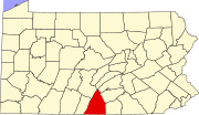
Kasiesville, Pennsylvania

Last updated

Kasiesville, Pennsylvania
Unincorporated community
USA Pennsylvania location map.svg
Red pog.svg
Kasiesville
Usa edcp location map.svg
Red pog.svg
Kasiesville
Coordinates: 39°44′55″N77°53′28″W / 39.74861°N 77.89111°W / 39.74861; -77.89111
Country United States
State Pennsylvania
County Franklin
Township Montgomery
Elevation
591 ft (180 m)
Time zone UTC-5 (Eastern (EST))
  Summer (DST) UTC-4 (EDT)
ZIP code
17236
Area code 717
GNIS feature ID1192704 [1]

Kasiesville is an unincorporated community in Montgomery Township in Franklin County, Pennsylvania, United States. Kasiesville is located on Pennsylvania Route 75, south of Mercersburg and north of the Maryland border. [2]

A variant name was "Camp Hill". [3] The community was founded as "Camp Hill" circa 1830. [4] A post office called Kasiesville was established in 1893, and remained in operation until 1905. [5]

Related Research Articles

<span class="mw-page-title-main">East Franklin Township, Armstrong County, Pennsylvania</span> Township in Pennsylvania, United States

East Franklin Township is a township in Armstrong County, Pennsylvania, United States. The population was 3,821 at the 2020 census, a decrease from the figure of 4,082 tabulated in 2010.

<span class="mw-page-title-main">Preston Township, Wayne County, Pennsylvania</span> Second-class township in Pennsylvania, United States

Preston is a second-class township in Wayne County, Pennsylvania, United States. The township's population was 1,014 at the time of the 2010 United States Census.

<span class="mw-page-title-main">Orson, Pennsylvania</span> Village in Pennsylvania, United States

Orson is a village in Preston Township, Wayne County, Pennsylvania, United States, situated in the Lake Region of the Poconos. It was once an important depot of the Scranton Division of the New York, Ontario & Western (O&W) Railway, but today, when it is known outside of its immediate vicinity, it is largely for being the site of the intersection of two state roads, Belmont Turnpike and Crosstown Highway, or as the location of Independent Lake Camp (ILC), since ILC's reputation and commercial reach, like those of most rural American summer camps, extend beyond the community in which the camp is physically located.

<span class="mw-page-title-main">Poyntelle, Pennsylvania</span> Village in Pennsylvania, United States

Poyntelle is a village that is located in Preston Township, Wayne County, Pennsylvania, United States, in the Lake Region of the Poconos.

Chesterville is an unincorporated community in Franklin Township in Chester County, Pennsylvania, United States. Chesterville is located at the intersection of Pennsylvania Route 841, Chesterville Road, and North Creek Road.

Lake Manjo is a manmade lake in Luzerne County, Pennsylvania, in the United States. It has a surface area of approximately 9 acres (3.6 ha) and is situated in Franklin Township. The surficial geology near the lake consists of bedrock and Wisconsinan Till. The lake is not accessible to the public. However, a camp known as Camp Orchard Hill is located near the lake.

Willow Hill is an unincorporated community in Metal Township in Franklin County, Pennsylvania, United States. Willow Hill is located along Pennsylvania Route 75 at its interchange with the Pennsylvania Turnpike, which is called the Willow Hill interchange.

<span class="mw-page-title-main">Pleasant Hall, Pennsylvania</span> Unincorporated community in Pennsylvania, United States

Pleasant Hall is an unincorporated community in Letterkenny Township in Franklin County, Pennsylvania, United States. Pleasant Hall is located at the intersection of state routes 533 and 997, north of Chambersburg and northeast of the Letterkenny Army Depot.

Sylvan is an unincorporated community in Warren Township in Franklin County, Pennsylvania, United States. Sylvan is located on Sylvan Drive, east of Pennsylvania Route 456.

Shimpstown is an unincorporated community in Montgomery Township in Franklin County, Pennsylvania, United States. Shimpstown is located on Pennsylvania Route 75, south of Mercersburg.

Claylick is an unincorporated community in Montgomery Township in Franklin County, Pennsylvania, United States. Claylick is located at the intersection of state routes 75 and 995, south of Mercersburg.

<span class="mw-page-title-main">Welsh Run, Pennsylvania</span> Unincorporated community in Pennsylvania, United States

Welsh Run is an unincorporated community in Montgomery Township in Franklin County, Pennsylvania, United States. Welsh Run is located at the intersection of state routes 416 and 995, southeast of Mercersburg.

Upton is an unincorporated community in Peters Township in Franklin County, Pennsylvania, United States. Upton is located at the intersection of state routes 16 and 995, east of Mercersburg and west of Greencastle.

Williamson is an unincorporated community in St. Thomas Township in Franklin County, Pennsylvania, United States. Williamson is located along Pennsylvania Route 995, northwest of Greencastle and southwest of Chambersburg.

Lemasters is an unincorporated community in Peters Township in Franklin County, Pennsylvania, United States. Lemasters is located at the intersection of Lemar Road and Steele Avenue, northeast of Mercersburg.

<span class="mw-page-title-main">Upper Strasburg, Pennsylvania</span> Unincorporated community in Pennsylvania, United States

Upper Strasburg is an unincorporated community that is located in Letterkenny Township in Franklin County, Pennsylvania, United States.

<span class="mw-page-title-main">Spring Run, Pennsylvania</span> Unincorporated community in Pennsylvania, United States

Spring Run is an unincorporated community in Fannett Township in Franklin County, Pennsylvania, United States. Spring Run is located at the intersection of state routes 75 and 641, west of Roxbury.

Dry Run is an unincorporated community in Fannett Township in Franklin County, Pennsylvania, United States. Dry Run is located at the intersection of Pennsylvania Route 75 and Back Road.

Amberson is an unincorporated community in Fannett Township in Franklin County, Pennsylvania, United States.

Morgan Hill, or Mammy Morgans Hill is a low mountain in Northampton County, Pennsylvania. The main peak rises to 673 feet (205 m), and is located in Williams Township, to the south of Easton. Morgan Hill overlooks the Delaware River, and Interstate 78. It is a part of the Reading Prong of the Appalachian Mountains.

References

  1. "Kasiesville". Geographic Names Information System . United States Geological Survey, United States Department of the Interior.
  2. Franklin County, Pennsylvania Highway Map (PDF) (Map). PennDOT. 2015. Retrieved January 2, 2016.
  3. U.S. Geological Survey Geographic Names Information System: Kasiesville, Pennsylvania
  4. M'Cauley, I. H. (1878). Historical Sketch of Franklin County, Pennsylvania. Patriot. p.  204.
  5. "Franklin County". Jim Forte Postal History. Retrieved June 19, 2017.