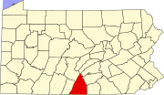
State Line, Franklin County, Pennsylvania

Last updated

State Line,
Franklin County,
Pennsylvania
USA Pennsylvania location map.svg
Red pog.svg
State Line
Usa edcp location map.svg
Red pog.svg
State Line
Coordinates: 39°44′30″N77°43′30″W / 39.74167°N 77.72500°W / 39.74167; -77.72500
Country United States
State Pennsylvania
County Franklin
Township Antrim
Elevation
[1]
676 ft (206 m)
Population
 (2020)
  Total2,804
  Density989/sq mi (382.0/km2)
Time zone UTC-5 (Eastern (EST))
  Summer (DST) UTC-4 (EDT)
ZIP code
17263
Area code 717
FIPS code 42-73848
GNIS feature ID 2634273 [1]

State Line is an unincorporated community and census-designated place (CDP) in Antrim Township, Franklin County, Pennsylvania, United States. It is next to the Maryland state line along Interstate 81 and U.S. Route 11 between Hagerstown, Maryland, and Greencastle. As of the 2020 census the population was 2,804. [2]

State Line was originally called Middleburg, and under the latter name laid out in 1812, and named for its location between Greencastle and Hagerstown, Maryland. [3] The present name comes from the fact that the community is located on the Maryland-Pennsylvania state line. [3] A post office called State Line was established in 1830. [4]

Related Research Articles

<span class="mw-page-title-main">Washington County, Maryland</span> County in Maryland, United States

Washington County is a county located in the western part of the U.S. state of Maryland. As of the 2020 census, the population was 154,705. It is the most populous county in the Western Maryland region and its county seat is Hagerstown.

<span class="mw-page-title-main">Franklin County, Pennsylvania</span> County in Pennsylvania, United States

Franklin County is a county in the Commonwealth of Pennsylvania. As of the 2020 census, the population was 155,932. Its county seat is Chambersburg.

<span class="mw-page-title-main">Antrim Township, Pennsylvania</span> Township in Pennsylvania, United States

Antrim Township is a township in Franklin County, Pennsylvania, United States. The population was 15,778 at the 2020 census, an increase over the figure of 12,504 tabulated in 2000. It was named after County Antrim in Northern Ireland.

<span class="mw-page-title-main">Chambersburg, Pennsylvania</span> Borough in Pennsylvania, United States

Chambersburg is a borough in and the county seat of Franklin County, in the South Central region of Pennsylvania, United States. It is in the Cumberland Valley, which is part of the Great Appalachian Valley, and 13 miles (21 km) north of Maryland and the Mason-Dixon line and 52 miles (84 km) southwest of Harrisburg, the state capital. According to the United States Census Bureau, Chambersburg's 2020 population was 21,903. When combined with the surrounding Greene, Hamilton, and Guilford Townships, the population of Greater Chambersburg is 52,273 people. The Chambersburg, PA Metropolitan Statistical Area includes surrounding Franklin County, and in 2010 included 149,618 people.

<span class="mw-page-title-main">Greencastle, Pennsylvania</span> Borough in Pennsylvania, United States

Greencastle is a borough in Franklin County in south-central Pennsylvania, United States. The population was 4,251 at the 2020 census. Greencastle lies within the Cumberland Valley of Pennsylvania.

<span class="mw-page-title-main">Mercersburg, Pennsylvania</span> Borough in Pennsylvania, United States

Mercersburg is a borough in Franklin County, Pennsylvania, United States. The borough is 72 miles (116 km) southwest of Harrisburg, the state capital.

<span class="mw-page-title-main">Western Maryland</span> Region in Maryland, US

Western Maryland, also known as the Maryland panhandle, is the portion of the U.S. state of Maryland that typically consists of Washington, Allegany, and Garrett counties. The region is bounded by Preston County, West Virginia, to the west, the Mason–Dixon line (Pennsylvania) to the north, and the Potomac River and West Virginia to the south. At one point, at the town of Hancock, the northern and southern boundaries are separated by just 1.8 miles, the narrowest stretch in the state.

<span class="mw-page-title-main">Conococheague Creek</span> Stream in the U.S. states of Pennsylvania and Maryland

Conococheague Creek, a tributary of the Potomac River, is a free-flowing stream that originates in Pennsylvania and empties into the Potomac River near Williamsport, Maryland. It is 80 miles (129 km) in length, with 57 miles (92 km) in Pennsylvania and 23 miles (37 km) in Maryland. The watershed of Conococheague Creek has an area of approximately 566 square miles (1,470 km2), out of which only 65 square miles (170 km2) are in Maryland.

<span class="mw-page-title-main">Pennsylvania Route 16</span> State highway in Pennsylvania, US

Pennsylvania Route 16 is a 43-mile-long (69 km) east–west state route located in southern Pennsylvania, United States. The western terminus of the route is at U.S. Route 522 in McConnellsburg. The eastern terminus is at the Mason–Dixon line in Liberty Township, where the road continues into Maryland as Maryland Route 140. PA 16 is a two-lane road that runs through rural areas in Fulton, Franklin, and Adams counties. The route heads east from McConnellsburg and crosses Tuscarora Mountain into Franklin County, where it continues east into the agricultural Cumberland Valley. Here, the passes through Mercersburg, Greencastle, and Waynesboro. PA 16 heads east through the South Mountain range, where it heads into Adams County and passes through Carroll Valley before coming to the Maryland border. PA 16 intersects several roads including PA 456 in Cove Gap, PA 75 and PA 416 in Mercersburg, PA 995 in Upton, US 11 and Interstate 81 (I-81) in Greencastle, PA 316 and PA 997 in Waynesboro, and PA 116 in Carroll Valley. The road's main name is Buchanan Trail in honor of 15th President James Buchanan, who was born near the road in Cove Gap.

<span class="mw-page-title-main">Lurgan Branch</span>

The Lurgan Branch is a railroad line owned and operated by the Norfolk Southern Railway in the U.S. states of Pennsylvania and Maryland. The line is part of the NS Harrisburg Division and runs from Harrisburg, Pennsylvania southwest to Hagerstown, Maryland along former Reading Company and Pennsylvania Railroad lines. Its northeast end is at a junction with the Harrisburg Line, Pittsburgh Line, Royalton Branch, and Amtrak's Keystone Corridor ; its southwest end is at the beginning of the Hagerstown District. At Lemoyne it intersects the Enola Branch.

<span class="mw-page-title-main">Interstate 81 in Maryland</span> Section of Interstate Highway in Washington County, Maryland, United States

Interstate 81 (I-81) is a part of the Interstate Highway System that runs from Dandridge, Tennessee, to Fishers Landing, New York. In Maryland, the Interstate Highway runs 12.08 miles (19.44 km) from the West Virginia state line at the Potomac River in Williamsport north to the Pennsylvania state line near Maugansville. I-81 is the primary north–south Interstate Highway in Washington County, connecting Hagerstown with Chambersburg and Harrisburg to the north and Martinsburg, Winchester, and Roanoke to the south.

<span class="mw-page-title-main">Monterey Pass</span> Mountain pass in Pennsylvania

Monterey Pass is a 1,300 feet (0.40 km) mountain pass located in Franklin County, southern Pennsylvania.

<span class="mw-page-title-main">U.S. Route 11 in Maryland</span> Section of U.S. Highway in Washington County, Maryland, U.S.

U.S. Route 11 (US 11) is a part of the United States Numbered Highway System that runs from New Orleans, Louisiana, to Rouses Point, New York. In Maryland, the federal highway runs 12.83 miles (20.65 km) from the West Virginia state line at the Potomac River in Williamsport north to the Pennsylvania state line near Maugansville. US 11 is the primary north–south surface highway in central Washington County, connecting Hagerstown with Williamsport to the south and Hagerstown Regional Airport to the north. The federal highway was once a major long-distance highway, but that role has been assumed by Interstate 81 (I-81), which parallels US 11 not only in Maryland but for most of its course from Tennessee to Upstate New York. US 11 is maintained by the Maryland State Highway Administration except for the municipally-maintained portions within the corporate limits of Williamsport and Hagerstown.

The Hagerstown and Frederick Railway, now defunct, was an American railroad of central Maryland built in the 19th and 20th centuries.

<span class="mw-page-title-main">Cumberland Valley Railroad</span> Early railroad in Pennsylvania, U.S.

The Cumberland Valley Railroad was an early railroad in Pennsylvania, United States, originally chartered in 1831 to connect with Pennsylvania's Main Line of Public Works. Freight and passenger service in the Cumberland Valley in south central Pennsylvania from near Harrisburg to Chambersburg began in 1837, with service later extended to Hagerstown, Maryland, and then extending into the Shenandoah Valley to Winchester, Virginia. It employed up to 1,800 workers.

<span class="mw-page-title-main">Pennsylvania Route 163</span> State highway in Franklin County, Pennsylvania, US

Pennsylvania Route 163 is a state highway in the U.S. state of Pennsylvania. The state highway, which is a two-lane undivided road its entire length, runs 2.384 miles (3.837 km) from the Maryland state line, where the highway continues south as Maryland Route 63, east to U.S. Route 11 in Antrim Township in southern Franklin County. The route begins at the Maryland border by following Williamsport Pike north before it quickly turns east onto Mason Dixon Road, with State Route 3001 continuing north on Williamsport Pike. PA 163 runs immediately to the north of the state line along Mason Dixon Road, coming to an interchange at Interstate 81 (I-81) before ending at US 11. The Williamsport Pike section of the route was originally a 19th-century turnpike connecting Williamsport, Maryland, with Greencastle, Pennsylvania. Williamsport Pike was paved by 1930 while Mason Dixon Road was paved in the 1930s. PA 163 was designated to its present alignment in the 1960s.

<span class="mw-page-title-main">Maryland Route 58</span> State highway in Washington County, Maryland, US

Maryland Route 58 is a state highway in the U.S. state of Maryland. Known for most of its length as Cearfoss Pike, the state highway runs 3.53 miles (5.68 km) from MD 63 in Cearfoss east to Key Circle in Hagerstown. MD 58 was constructed in the late 1920s along what was originally a turnpike called the Hagerstown and Cross Roads Turnpike.

<span class="mw-page-title-main">Maryland Route 63</span> State highway in Washington County, Maryland, US

Maryland Route 63 is a state highway in the U.S. state of Maryland. The state highway runs 16.99 miles (27.34 km) from MD 65 in Fairplay north to the Pennsylvania state line near Cearfoss, where the highway continues as Pennsylvania Route 163. MD 63 is an L-shaped route that passes through central Washington County on the south and west sides of Hagerstown. The state highway connects with multiple local and long-distance highways that serve Hagerstown, including Interstate 81 (I-81) and U.S. Route 11 in Williamsport and I-70 and US 40 in Huyett. MD 63 also joins MD 68 in a concurrency through Williamsport.

<span class="mw-page-title-main">Hagerstown, Maryland</span> City in Maryland, United States

Hagerstown is a city in and the county seat of Washington County, Maryland, United States. The population was 43,527 at the 2020 census. Hagerstown ranks as Maryland's sixth-most populous incorporated city and is the most populous city in the Maryland Panhandle.

Marion is an unincorporated community and census-designated place (CDP) in Franklin County, Pennsylvania, United States. As of the 2020 census, the population was 851.

References

  1. 1 2 U.S. Geological Survey Geographic Names Information System: State Line, Franklin County, Pennsylvania
  2. "Explore Census Data".
  3. 1 2 M'Cauley, I. H. (1878). Historical Sketch of Franklin County, Pennsylvania. Patriot. p.  214.
  4. "Franklin County". Jim Forte Postal History. Retrieved June 19, 2017.