Lurgan Township, Pennsylvania

Last updated
Lurgan Township,
Franklin County, Pennsylvania
Maclay's Mill Twin Bridge (East & West), Spanning Conodoguinet Creek at Maclay's Mill Road , Mowersville vicinity (Franklin County, Pennsylvania).jpg
Map of Franklin County, Pennsylvania Highlighting Lurgan Township.PNG
Map of Franklin County, Pennsylvania highlighting Lurgan Township
Map of Pennsylvania highlighting Franklin County.svg
Map of Franklin County, Pennsylvania
Country United States
State Pennsylvania
County Franklin
Settled1736
Incorporated1743
Area
[1]
  Total32.83 sq mi (85.03 km2)
  Land32.72 sq mi (84.74 km2)
  Water0.11 sq mi (0.29 km2)
Population
 (2020)
  Total2,207
  Estimate 
(2016) [2]
2,179
  Density66.60/sq mi (25.71/km2)
Time zone UTC-5 (Eastern (EST))
  Summer (DST) UTC-4 (EDT)
Area code 717
FIPS code 42-055-45496
Website www.lurgantownship.org

Lurgan Township is a township in Franklin County, Pennsylvania, United States. The population was 2,207 at the 2020 census. [3]

Contents

It was named after the town of Lurgan in Northern Ireland. [4]

History

The McClay's Twin Bridge (East) and McClay's Twin Bridge (West) were listed on the National Register of Historic Places in 1988. [5]

Geography

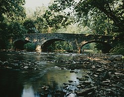
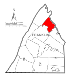
Lurgan Township is in northeastern Franklin County, bordered to the northeast by Cumberland County. The southeastern two-thirds of the township are in the Cumberland Valley, while the northwestern third is in the Ridge and Valley Province of the Appalachian Mountains. Conodoguinet Creek, a tributary of the Susquehanna River, forms the southern boundary of the township, while the northwestern boundary follows the crest of Kittatinny Mountain. Blue Mountain runs parallel to and east of Kittatinny Mountain through the township.

Interstate 76, the Pennsylvania Turnpike, crosses the northern part of the township, with access from Exit 201, the Blue Mountain Interchange. West of the interchange, the turnpike passes through the Blue Mountain Tunnel and Kittatinny Mountain Tunnel in rapid succession. The largest community in the township is Roxbury, in the southwest. Other unincorporated communities are McKinney, Otterbein, Mowersville, and Lurgan.

According to the United States Census Bureau, the township has a total area of 32.8 square miles (85.0 km2), of which 32.7 square miles (84.7 km2) is land and 0.1 square miles (0.3 km2), or 0.34%, is water. [6]

Neighboring Townships

Communities

Demographics

Historical population
CensusPop.Note
2000 2,014
2010 2,1516.8%
2020 2,2072.6%
2016 (est.)2,179 [2] 1.3%
U.S. Decennial Census [7]

As of the census [8] of 2000, there were 2,014 people, 710 households, and 572 families residing in the township. The population density was 61.4 inhabitants per square mile (23.7/km2). There were 749 housing units at an average density of 22.8/sq mi (8.8/km2). The racial makeup of the township was 98.76% White, 0.10% African American, 0.05% Native American, 0.20% Asian, 0.05% Pacific Islander, 0.35% from other races, and 0.50% from two or more races. Hispanic or Latino of any race were 0.50% of the population.

There were 710 households, out of which 36.6% had children under the age of 18 living with them, 71.8% were married couples living together, 5.2% had a female householder with no husband present, and 19.4% were non-families. 15.9% of all households were made up of individuals, and 6.6% had someone living alone who was 65 years of age or older. The average household size was 2.84 and the average family size was 3.18.

In the township the population was spread out, with 28.4% under the age of 18, 9.1% from 18 to 24, 28.4% from 25 to 44, 23.6% from 45 to 64, and 10.6% who were 65 years of age or older. The median age was 34 years. For every 100 females there were 104.9 males. For every 100 females age 18 and over, there were 102.7 males.

The median income for a household in the township was $41,681, and the median income for a family was $46,964. Males had a median income of $31,366 versus $25,469 for females. The per capita income for the township was $17,276. About 4.0% of families and 7.7% of the population were below the poverty line, including 11.6% of those under age 18 and 11.2% of those age 65 or over.

Related Research Articles

<span class="mw-page-title-main">Franklin County, Pennsylvania</span> County in Pennsylvania, United States

Franklin County is a county in the Commonwealth of Pennsylvania. As of the 2020 census, the population was 155,932. Its county seat is Chambersburg.

<span class="mw-page-title-main">Hopewell Township, Cumberland County, Pennsylvania</span> Township in Pennsylvania, United States

Hopewell Township is a township in Cumberland County, Pennsylvania, United States. The population was 2,329 at the 2010 census, up from 2,096 at the 2000 census.

<span class="mw-page-title-main">Lower Frankford Township, Cumberland County, Pennsylvania</span> Township in Pennsylvania, United States

Lower Frankford Township is a township in Cumberland County, Pennsylvania, United States. The population was 1,732 at the 2010 census.

<span class="mw-page-title-main">Monroe Township, Cumberland County, Pennsylvania</span> Township in Pennsylvania, United States

Monroe Township is a township in Cumberland County, Pennsylvania, United States. The population was 5,823 at the 2010 census.

<span class="mw-page-title-main">Penn Township, Cumberland County, Pennsylvania</span> Township in Pennsylvania, United States

Penn Township is a township in Cumberland County, Pennsylvania, United States, established on October 23, 1860, from Upper Dickinson Township. The population was 2,924 at the 2010 census.

<span class="mw-page-title-main">Shippensburg Township, Cumberland County, Pennsylvania</span> Township in Pennsylvania, United States

Shippensburg Township is a township in Cumberland County, Pennsylvania, United States, adjacent to the borough of Shippensburg. The population of the township was 5,429 at the 2010 census, up from 4,504 at the 2000 census. The township is the location of Shippensburg University of Pennsylvania.

<span class="mw-page-title-main">Silver Spring Township, Cumberland County, Pennsylvania</span> Township in Pennsylvania, United States

Silver Spring Township is a township in Cumberland County, Pennsylvania, United States. The population was 13,657 at the 2010 census, up from 10,592 at the 2000 census.

<span class="mw-page-title-main">South Middleton Township, Cumberland County, Pennsylvania</span> Township in Pennsylvania, United States

South Middleton Township is a township in Cumberland County, Pennsylvania, United States. The population was 14,663 at the 2010 census, up from 12,939 at the 2000 census.

<span class="mw-page-title-main">South Newton Township, Cumberland County, Pennsylvania</span> Township in Pennsylvania, United States

South Newton Township is a township in Cumberland County, Pennsylvania, United States. The population was 1,383 at the 2010 census.

<span class="mw-page-title-main">Southampton Township, Cumberland County, Pennsylvania</span> Township in Pennsylvania, United States

Southampton Township is a township in Cumberland County, Pennsylvania, United States. The population was 6,359 at the 2010 census, up from 4,787 at the 2000 census.

<span class="mw-page-title-main">Upper Mifflin Township, Cumberland County, Pennsylvania</span> Township in Pennsylvania, United States

Upper Mifflin Township is a township in Cumberland County, Pennsylvania, United States. The population was 1,304 at the 2010 census.

<span class="mw-page-title-main">Fannett Township, Pennsylvania</span> Township in Pennsylvania, United States

Fannett Township is a township in Franklin County, Pennsylvania, United States. The population was 2,483 at the 2020 census. The township derives its name as an older variant spelling of Fanad, County Donegal, from early Irish settlement in the area. It was formed before 1762, and until about 1795 included the area now in Metal Township.

<span class="mw-page-title-main">Letterkenny Township, Pennsylvania</span> Township in Pennsylvania, United States

Letterkenny Township is a township that is located in Franklin County, Pennsylvania, United States. The population was 2,462 at the time of the 2020 census, up from 2,074 at the 2000 census.

<span class="mw-page-title-main">Metal Township, Pennsylvania</span> Township in Pennsylvania, United States

Metal Township is a township that is located in Franklin County, Pennsylvania, United States. The population was 1,768 at the time of the 2020 census.

<span class="mw-page-title-main">Montgomery Township, Franklin County, Pennsylvania</span> Township in Pennsylvania, United States

Montgomery Township is a township that is located in Franklin County, Pennsylvania, United States. The population was 5,740 at the time of the 2020 census, an increase from the 4,949 figure that was counted during the 2000 census.

<span class="mw-page-title-main">Southampton Township, Franklin County, Pennsylvania</span> Township in Pennsylvania, United States

Southampton Township is a township that is located in Franklin County, Pennsylvania, United States. The population was 8,566 at the time of the 2020 census, an increase from the figure of 6,138 that was documented by the 2000 census.

<span class="mw-page-title-main">Tuscarora Township, Juniata County, Pennsylvania</span> Township in Pennsylvania, United States

Tuscarora Township is a township that is located in southwestern Juniata County, Pennsylvania, United States. The population was 1,138 at the time of the 2020 census.

<span class="mw-page-title-main">Rush Township, Northumberland County, Pennsylvania</span> Township in Pennsylvania, United States

Rush Township is a township that is located in Northumberland County, Pennsylvania, United States. The population at the time of the 2010 Census was 1,122, a decline from the figure of 1,189 that was tabulated in 2000.

<span class="mw-page-title-main">Toboyne Township, Perry County, Pennsylvania</span> Township in Pennsylvania, United States

Toboyne Township is a township in Perry County, Pennsylvania, United States. The population was 467 at the 2020 census. Big Spring State Forest Picnic Area is on the western end of Toboyne Township near Conococheague Mountain. Fowlers Hollow State Park is also in the township. It is named after Taughboyne, County Donegal, Ireland.

<span class="mw-page-title-main">East Huntingdon Township, Westmoreland County, Pennsylvania</span> Township in Pennsylvania, United States

East Huntingdon Township is a township in Westmoreland County, Pennsylvania, United States. The population was 7,712 at the 2020 census. From 1978 to 1988, the township had been home to the Volkswagen Westmoreland Assembly Plant, which later became a Sony plant. As of 2020 companies there include DNP, Cenveo, and Siemens.

References

  1. "2016 U.S. Gazetteer Files". United States Census Bureau. Retrieved Aug 13, 2017.
  2. 1 2 "Population and Housing Unit Estimates" . Retrieved June 9, 2017.
  3. "Explore Census Data".
  4. M'Cauley, I. H. (1878). Historical Sketch of Franklin County, Pennsylvania. Patriot. p.  188.
  5. "National Register Information System". National Register of Historic Places . National Park Service. July 9, 2010.
  6. "Geographic Identifiers: 2010 Census Summary File 1 (G001), Lurgan township, Franklin County, Pennsylvania". American FactFinder. U.S. Census Bureau. Archived from the original on February 13, 2020. Retrieved August 9, 2016.
  7. "Census of Population and Housing". Census.gov. Retrieved June 4, 2016.
  8. "U.S. Census website". United States Census Bureau . Retrieved 2008-01-31.

40°02′36″N77°34′59″W / 40.04333°N 77.58306°W / 40.04333; -77.58306