Lander, Maryland

Last updated

Lander, Maryland
Lockhouse and Lock 29, C&O Canal, Lander, MD.jpg
C&O Canal Lockhouse and Lock 29 in Lander
USA Maryland location map.svg
Red pog.svg
Lander
Location in Maryland
Usa edcp location map.svg
Red pog.svg
Lander
Lander (the United States)
Coordinates: 39°18′32″N77°33′33″W / 39.3089907°N 77.5591550°W / 39.3089907; -77.5591550
Country Flag of the United States.svg  United States of America
State Flag of Maryland.svg  Maryland
County Flag of Frederick County, Maryland.svg Frederick
Elevation
91 m (299 ft)

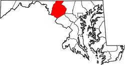
Lander is an unincorporated community in Frederick County, Maryland, United States. [1] Lock 29 on the C&O Canal is located in Lander.

Related Research Articles

<span class="mw-page-title-main">John Hanson</span> American Founding Father and merchant (1721-1783)

John Hanson was an American Founding Father, merchant, and politician from Maryland during the Revolutionary Era. In 1779, Hanson was elected as a delegate to the Continental Congress after serving in a variety of roles for the Patriot cause in Maryland. He signed the Articles of Confederation in 1781 after Maryland joined the other states in ratifying them. In November 1781, he was elected as the first President of the Confederation Congress, following ratification of the articles. For this reason, some of Hanson's biographers have argued that he was actually the first holder of the office of President of the United States.

<span class="mw-page-title-main">Maryland</span> U.S. state

Maryland is a state in the Mid-Atlantic region of the United States. The state borders Virginia to its south, West Virginia to its west, Pennsylvania to its north, Delaware to its east, the Atlantic Ocean, and the national capital of Washington, D.C. With a total area of 12,407 square miles (32,130 km2), Maryland is the ninth-smallest state by land area, and its population of 6,177,224 ranks it the 18th-most populous state and the fifth-most densely populated. Maryland's most populous city is Baltimore, and the capital is Annapolis. Occasional nicknames include Old Line State, the Free State, and the Chesapeake Bay State. It is named after Henrietta Maria, the French-born queen of England, Scotland, and Ireland during the 17th century.

<span class="mw-page-title-main">Frederick County, Maryland</span> County in Maryland, United States

Frederick County is located in Maryland, United States. As of the 2020 U.S. census, the population was 271,717. The county seat is Frederick.

<span class="mw-page-title-main">Frederick, Maryland</span> City in Maryland, United States

Frederick is a city in, and the county seat of, Frederick County, Maryland, United States. It is located at an important crossroads at the intersection of a major north–south Native American trail and east–west routes to the Chesapeake Bay, both at Baltimore and what became Washington, D.C., and across the Appalachian mountains to the Ohio River watershed. Frederick's population was 78,171 people as of the 2020 census, making it the second-largest incorporated city in Maryland behind Baltimore. It is a part of the Washington metropolitan area, which is part of a greater Washington–Baltimore combined statistical area.

<span class="mw-page-title-main">Catonsville, Maryland</span> Census-designated place in Maryland, United States

Catonsville is a census-designated place (CDP) in Baltimore County, Maryland. The population was 44,701 at the 2020 US Census. The community is a streetcar suburb of Baltimore along the city's western border. The town is known for its proximity to the Patapsco River and Patapsco Valley State Park, making it a regional mountain biking hub. The town is also notable as a local hotbed of music, earning it the official nickname of "Music City, Maryland." Catonsville contains the majority of the University of Maryland, Baltimore County (UMBC), a major public research university with close to 14,000 students.

<span class="mw-page-title-main">Prince Frederick, Maryland</span> Census-designated place in Maryland, United States

Prince Frederick is an unincorporated community and census-designated place (CDP) in Calvert County, Maryland, United States. As of the 2020 census, the population of Prince Frederick was 3,226, up from 2,538 in 2010. It is the county seat of Calvert County.

<span class="mw-page-title-main">Point of Rocks, Maryland</span> Census-designated place in Maryland, United States

Point of Rocks is an unincorporated community and census-designated place (CDP) in Frederick County, Maryland. As of the 2010 census, it had a population of 1,466.

<span class="mw-page-title-main">Thomas Johnson (judge)</span> US Supreme Court justice from 1791 to 1793

Thomas Johnson was an 18th-century American lawyer, politician, and patriot. He was a delegate to the First Continental Congress in 1774, where he signed the Continental Association; commander of the Maryland militia in 1776; and elected first (non-Colonial) governor of Maryland in 1777. Throughout his career, Johnson maintained a personal and political friendship with George Washington, who gave him a recess appointment as an associate justice of the Supreme Court in August 1791. He served only briefly, resigning in January 1793, citing health issues.

<span class="mw-page-title-main">Province of Maryland</span> British colony in North America (1634–1776)

The Province of Maryland was an English and later British colony in North America from 1634 until 1776, when it made common cause with the group of Thirteen Colonies in rebellion against Great Britain and, finally in 1781—as the 13th signatory to the Articles of Confederation—it ratified its perpetual union with that group as the state of Maryland. The province's first settlement and capital was St. Mary's City, located at the southern end of St. Mary's County, a peninsula in the Chesapeake Bay that is bordered by four tidal rivers.

Thomas Sim Lee was an American planter, patriot and politician who served as Maryland Governor for five one-year terms, as well as in the Congress of the Confederation (1783-84), Maryland Ratification Convention of 1788 and House of Delegates in 1787. He also held local offices and owned many town lots in Georgetown (which became part of the new federal city, Washington, District of Columbia,and spent his final decades operating "Needwood" plantation in Frederick County, Maryland. In addition to working closely with many of the Founding fathers, he played an important part in the birth of his state and the nation.

Monrovia is an unincorporated community and census-designated place (CDP) in Frederick County, in the U.S. state of Maryland. As of the 2020 census it had a population of 2,702. The ZIP code for the area is 21770.

<span class="mw-page-title-main">Gambrill State Park</span> State park in Maryland, United States

Gambrill State Park is a public recreation area located on Catoctin Mountain near the city of Frederick in Frederick County, Maryland. The state park is known for the dramatic views of the surrounding area that can be seen from stone overlooks built in the 1930s by the Civilian Conservation Corps. The park is operated by the Maryland Department of Natural Resources.

<span class="mw-page-title-main">Buckeystown, Maryland</span> Census-designated place in Maryland, United States

Buckeystown is an unincorporated community and census-designated place (CDP) in Frederick County, Maryland, United States. As of the 2010 census the population was 1,019. Buckeystown Historic District and Buckingham House and Industrial School Complex were listed on the National Register of Historic Places in 1982. Carrollton Manor was listed in 1997. Former Congressman Roscoe Bartlett lives on a farm in the town.

<span class="mw-page-title-main">Carroll Creek (Maryland)</span> River in Maryland, United States

Carroll Creek is an 8.3-mile-long (13.4 km) tributary of the Monocacy River in Frederick County, Maryland. The headwaters of the creek are located on the eastern slopes of Catoctin Mountain, southeast of Gambrill State Park. The stream runs roughly east through the city of Frederick to the Monocacy, which drains to the Potomac River. The Shawnee Indians, who called the Monocacy River Monnockkesey, named Carroll Creek Walkwaki Methtegui,.

<span class="mw-page-title-main">Schifferstadt (Frederick, Maryland)</span> Historic house in Maryland, United States

Schifferstadt, Also known as Scheifferstadt, is the oldest standing house in Frederick, Maryland. Built in 1758, it is one of the nation's finest examples of German-Georgian colonial architecture. It was designated a National Historic Landmark in 2016.

Fort Tonoloway State Park is an undeveloped Maryland state park located near present-day Hancock. Fort Tonoloway was a frontier fort built in 1755 by Lt. Thomas Stoddert and men from the Maryland State Militia. The fort was also known as Stoddert's Fort. It was abandoned in 1756 when Fort Frederick was constructed.

<span class="mw-page-title-main">Sabillasville, Maryland</span> Census-designated place in Maryland

Sabillasville is an unincorporated community and census-designated place in Frederick County, Maryland, United States. As of the 2010 census it had a population of 354.

<span class="mw-page-title-main">Double Pipe Creek</span> Stream in the U.S. state of Maryland

Double Pipe Creek, sometimes called Pipe Creek, is a major tributary of the Monocacy River in Carroll County and Frederick County in Maryland, located several miles north and west of Westminster. The creek is only 1.6 miles (2.6 km) long, but is formed by the confluence of two much longer streams, Big Pipe Creek and Little Pipe Creek.

Tuscarora Creek is a 7.7-mile-long (12.4 km) tributary of the Monocacy River in Frederick County, Maryland, in the United States.

References

  1. "Geographic Names Information System". edits.nationalmap.gov. Retrieved April 21, 2022.

https://en.m.wikipedia.org/wiki/Frederick_W._Lander