Clover Hill, Maryland

Last updated

Clover Hill, Maryland
Frederick County Maryland Incorporated and Unincorporated areas Clover Hill Highlighted.svg
Coordinates: 39°27′27″N77°25′47″W / 39.45750°N 77.42972°W / 39.45750; -77.42972
CountryFlag of the United States.svg  United States
State Flag of Maryland.svg  Maryland
County Flag of Frederick County, Maryland.svg Frederick
Area
  Total1.2 sq mi (3.2 km2)
  Land1.2 sq mi (3.2 km2)
  Water0.0 sq mi (0.0 km2)
Elevation
[1]
364 ft (111 m)
Population
 (2000)
  Total3,260
  Density2,659/sq mi (1,026.8/km2)
Time zone UTC−5 (Eastern (EST))
  Summer (DST) UTC−4 (EDT)
FIPS code 24-18100
GNIS feature ID2389334 [1]

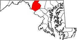
Clover Hill is an unincorporated community and former census-designated place (CDP) in Frederick County, Maryland, United States. The population was 3,260 at the 2000 census. The area was not listed as a CDP for the 2010 census, and no population total was published.

Contents

Geography

Clover Hill is located in central Frederick County and is bordered on all four sides by the city of Frederick, with the downtown section of Frederick to the south.

According to the United States Census Bureau, in 2000 the CDP had a total area of 1.2 square miles (3.1 km2), all land.

In the center of the community is a large park, with two small wetlands that dry in the winter.

Demographics

As of the census [2] of 2000, there were 3,260 people, 1,133 households, and 984 families residing in the CDP. The population density was 2,659.4 inhabitants per square mile (1,026.8/km2). There were 1,143 housing units at an average density of 932.4 per square mile (360.0/km2). The racial makeup of the CDP was 92.82% White, 1.53%African American, 0.15% Native American, 4.05% Asian, 0.37% from other races, and 1.07% from two or more races. Hispanic or Latino of any race were 1.78% of the population.

There were 1,133 households, out of which 40.9% had children under the age of 18 living with them, 80.2% were married couples living together, 4.1% had a female householder with no husband present, and 13.1% were non-families. 10.9% of all households were made up of individuals, and 5.5% had someone living alone who was 65 years of age or older. The average household size was 2.87 and the average family size was 3.10.

In the CDP, the population was spread out, with 27.5% under the age of 18, 4.5% from 18 to 24, 22.1% from 25 to 44, 33.7% from 45 to 64, and 12.3% who were 65 years of age or older. The median age was 43 years. For every 100 females, there were 94.9 males. For every 100 females age 18 and over, there were 96.5 males.

The median income for a household in the CDP was $87,632, and the median income for a family was $90,598. Males had a median income of $68,821 versus $35,147 for females. The per capita income for the CDP was $33,378. None of the families and 0.3% of the population were living below the poverty line, including no under eighteens and none of those over 64.

Related Research Articles

<span class="mw-page-title-main">Vine Hill, California</span> Census-designated place in California, United States

Vine Hill is a census-designated place (CDP) in Contra Costa County, California, United States. The population was 3,761 at the 2010 census. It is located 2.25 miles (3.6 km) east of downtown Martinez.

<span class="mw-page-title-main">West Bishop, California</span> Census-designated place in California, United States

West Bishop is a census-designated place (CDP) in Inyo County, California, United States. The population was 2,607 at the 2010 census, down from 2,807 at the 2000 census.

<span class="mw-page-title-main">Golden Hills, California</span> Census-designated place in California, United States

Golden Hills is a census-designated place (CDP) in the Tehachapi Mountains, in Kern County, California, United States. The population was 8,656 at the 2010 census, up from 7,434 at the 2000 census. Golden Hills adjoins the city of Tehachapi on the west.

<span class="mw-page-title-main">North Tustin, California</span> Place in California, United States

North Tustin is an unincorporated community and census designated place (CDP) in Orange County, California. The population was 25,718 at the 2020 census, up from 24,917 in 2010. For statistical purposes, the United States Census Bureau has defined North Tustin as a census-designated place (CDP). It is both the largest CDP and largest unincorporated community in Orange County. The CDP's name was changed from Tustin Foothills in 2005. Located outside the city limits of Tustin, North Tustin has 92705 and 92780 ZIP Codes.

<span class="mw-page-title-main">Crestline, California</span> Census-designated place in California, United States

Crestline is a census-designated place in the San Bernardino Mountains of San Bernardino County, California, USA. The population was 10,770 at the 2010 census, up from 10,218 at the 2000 census.

Saybrook Manor is a community and census-designated place (CDP) in Old Saybrook, a town in Middlesex County, Connecticut, United States. The population was 1,127 at the 2020 census. The Saybrook Manor section is generally the area south of U.S. Route 1 between the Westbrook town line and the Oyster River.

<span class="mw-page-title-main">Long Hill, Groton, Connecticut</span> Census-designated place in Connecticut, United States

Long Hill is a census-designated place (CDP) in the town of Groton in New London County, Connecticut, United States. The population was 4,205 at the 2010 census.

<span class="mw-page-title-main">Frankfort Square, Illinois</span> Census-designated place in Illinois, United States

Frankfort Square is a census-designated place (CDP) in Will County, Illinois, United States. Per the 2020 census, the population was 8,968.

<span class="mw-page-title-main">Cloverly, Maryland</span> Census-designated place in Maryland, United States

Cloverly is an unincorporated town and census-designated place in Montgomery County, Maryland, United States. Its population was 15,285 as of the 2020 census.

<span class="mw-page-title-main">Level Park–Oak Park, Michigan</span> Census-designated place & unincorporated community in Michigan, United States

Level Park–Oak Park is a census-designated place for statistical purposes in Calhoun County in the U.S. state of Michigan. The CDP population was 3,260 at the 2020 census. The CDP is immediately northwest of the city of Battle Creek and is part of the Battle Creek Metropolitan Statistical Area.

<span class="mw-page-title-main">Silver Ridge, New Jersey</span> Populated place in Ocean County, New Jersey, US

Silver Ridge is an unincorporated community and census-designated place (CDP) located within Berkeley Township, in Ocean County, in the U.S. state of New Jersey. As of the 2010 United States Census, the CDP's population was 1,133.

<span class="mw-page-title-main">East Quogue, New York</span> Hamlet and census-designated place in New York, United States

East Quogue is a hamlet and census-designated place (CDP) in the Town of Southampton in Suffolk County, on Long Island, in New York, United States. The population was 4,757 at the 2010 census.

<span class="mw-page-title-main">East Flat Rock, North Carolina</span> Census-designated place in North Carolina, United States

East Flat Rock is an unincorporated area and census-designated place (CDP) in Henderson County, North Carolina, United States. The population was 4,995 at the 2010 census, up from 4,151 at the 2000 census. It is part of the Asheville Metropolitan Statistical Area.

<span class="mw-page-title-main">Fruit Hill, Ohio</span> Census-designated place in Ohio, United States

Fruit Hill is a census-designated place (CDP) in Hamilton County, Ohio, United States. The population was 3,748 at the 2020 census.

Shiloh is a census-designated place (CDP) in Harrison Township in Montgomery County, Ohio, United States. It was delineated as a census-designated place at the 2000 census, at which time its population was 11,272. It was not delineated as a CDP at the 2010 census. It is located directly north of the city of Dayton and is part of the Dayton Metropolitan Statistical Area.

<span class="mw-page-title-main">West Hills, Pennsylvania</span> Census-designated place in Pennsylvania, United States

West Hills is a census-designated place (CDP) in Armstrong County, Pennsylvania, United States. The population was 1,228 at the 2020 census.

<span class="mw-page-title-main">Colonial Pine Hills, South Dakota</span> CDP in South Dakota, United States

Colonial Pine Hills is a census-designated place (CDP) and unincorporated community in Pennington County, South Dakota, United States. The population was 1,903 at the 2020 census.

<span class="mw-page-title-main">Calverton, Maryland</span> Census-designated place in Maryland, United States

Calverton is an unincorporated area and census-designated place located on the boundary between Montgomery and Prince George's counties, Maryland, in the United States. At the 2020 census, it had a population of 17,316.

<span class="mw-page-title-main">East Greenbush (CDP), New York</span> CDP in New York, United States

East Greenbush is a census-designated place (CDP) in Rensselaer County, New York, United States. The population was 6,266 at the 2020 census.

Orono is a census-designated place (CDP) consisting of the eastern portion of the town of Orono in Penobscot County, Maine, United States. The population of the CDP was 9,474 at the 2010 census.

References

  1. 1 2 U.S. Geological Survey Geographic Names Information System: Clover Hill, Maryland
  2. "U.S. Census website". United States Census Bureau . Retrieved January 31, 2008.