Lewistown | |
---|---|
Coordinates: 39°22′37″N77°25′09″W / 39.37694°N 77.41917°W [1] | |
Country | United States of America |
State | Maryland |
County | Frederick |
Area | |
• Total | 0.65 sq mi (1.68 km2) |
• Land | 0.64 sq mi (1.66 km2) |
• Water | 0.01 sq mi (0.02 km2) |
Elevation | 427 ft (130 m) |
Population (2020) | |
• Total | 458 |
• Density | 715.63/sq mi (276.41/km2) |
Time zone | UTC-5 (Eastern (EST)) |
• Summer (DST) | UTC-4 (EDT) |
FIPS code | 24-46650 |
GNIS feature ID | 2806299 [1] |
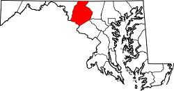
Lewistown is a census designated place and unincorporated community in Frederick County, Maryland, United States. [3] Lewistown Elementary school, part of Frederick County Public Schools, is located in Lewistown. The town, founded in 1841, has had a school since the 19th century. There is a large elderly population in the community. [4] It first appeared as a CDP in the 2020 Census with a population of 458. [5]
The Lewistown Volunteer Fire Company was established in 1970, when the community purchased the first diesel engine in the county. Today, the fire department has six different apparatus: Engine Tanker 224, Engine 221, Tanker 22, Brush 226, Utility 22 and Ambulance 229. The fire station is staffed by volunteers from the community and two paid employees of the county. [6]
On June 23, 1863, General John F. Reynolds' I Corps marched through Lewistown on their way to Gettysburg in pursuit of the Confederate army. [7]
Census | Pop. | Note | %± |
---|---|---|---|
2020 | 458 | — | |
U.S. Decennial Census [8] 2020 [9] |
Race / Ethnicity | Pop 2020 [9] | % 2020 |
---|---|---|
White alone (NH) | 396 | 86.46% |
Black or African American alone (NH) | 11 | 2.40% |
Native American or Alaska Native alone (NH) | 0 | 0.00% |
Asian alone (NH) | 2 | 0.44% |
Pacific Islander alone (NH) | 1 | 0.22% |
Some Other Race alone (NH) | 0 | 0.00% |
Mixed Race/Multi-Racial (NH) | 15 | 3.28% |
Hispanic or Latino (any race) | 33 | 7.21% |
Total | 458 | 100.00% |
Note: the US Census treats Hispanic/Latino as an ethnic category. This table excludes Latinos from the racial categories and assigns them to a separate category. Hispanics/Latinos can be of any race.
Frederick County is located in Maryland, United States. As of the 2020 U.S. census, the population was 271,717. The county seat is Frederick.
Bryans Road is a census-designated place (CDP) in Charles County, Maryland, United States. Per the 2020 census, the population was 8,650.
Green Valley is an unincorporated area and census-designated place (CDP) in southern Frederick County, Maryland, United States. The population was 12,643 at the 2020 census. The area was listed as a census-designated place in 2000 but not listed as part of any CDP at the 2010 census. It was re-designated a census-designated place for the 2020 census.
Adelphi is an unincorporated area and census-designated place in Prince George's County, Maryland, United States. Per the 2020 Census, the population was 16,823. Adelphi includes the following subdivisions; Adelphi, Adelphi Park, Adelphi Hills, Adelphi Terrace, Adelphi Village, Buck Lodge, Chatham, Cool Spring Terrace, Hillandale Forest, Holly Hill Manor, Knollwood, Lewisdale, and White Oak Manor.
Chillum is an unincorporated area and census-designated place in Prince George's County, Maryland, United States, bordering Washington, D.C., and Montgomery County.
Glenn Dale is an unincorporated area and census-designated place (CDP) in Prince George's County, Maryland, United States. The population was 14,698 at the 2020 census. Glenn Dale is home to the Glenn Dale Hospital, an abandoned sanatorium, and the USDA Plant Introduction Station.
Langley Park is an unincorporated area and census-designated place (CDP) in Prince George's County, Maryland, United States. It is located inside the Capital Beltway, on the northwest edge of Prince George's County, bordering Montgomery County. Per the 2020 census, the population was 20,126.
Marlton is an unincorporated area and census-designated place (CDP) in Prince George's County, Maryland, United States. The population was 9,802 at the 2020 census. The Marlton housing development, at first briefly called "Brandywine Country", grew up along U.S. Route 301 in the 1970s, and is part of the greater Upper Marlboro community. Originally made up of only single-family homes, more recently townhouses have been added.
Rosaryville is an unincorporated area and census-designated place (CDP) in Prince George's County, Maryland, United States, located south of Cinton and Upper Marlboro beside U.S. Route 301. Per the 2020 census, the population was 11,548. including housing developments and rural open space. It was named for a local Roman Catholic church. Close to Rosaryville are the Marlton housing development, Maryland Veterans Cemetery, the Southern Maryland Farmers Market, and Rosaryville State Park.
Woodlawn is an unincorporated area and census-designated place (CDP) in Prince George's County, Maryland, United States. As of the 2020 census it had a population of 7,541.
Lanham is an unincorporated community and census-designated place in Prince George's County, Maryland. As of the 2020 United States Census it had a population of 11,282. The New Carrollton station as well as an Amtrak station are across the Capital Beltway in New Carrollton, Maryland. Doctors Community Hospital is located in Lanham.
Peppermill Village is an unincorporated community near Maryland Route 214 in Prince George's County, Maryland, United States. Per the 2020 census, the population was 5,264. FedExField, Metrorail's Blue Line, and Hampton Mall shopping center are all located nearby. Because it is not formally incorporated, it has no official boundaries, but the United States Census Bureau has defined a census-designated place (CDP) consisting of Peppermill Village and the adjacent community of Carmody Hills, for statistical purposes.
Glassmanor is an unincorporated community and census-designated place in Prince George's County, Maryland, United States. As of the 2020 census, it had a population of 18,430. In the 1990 and 2000 censuses, the United States Census Bureau had placed Glassmanor and the adjacent community of Oxon Hill in the "Oxon Hill-Glassmanor" census-designated place for statistical purposes. Glassmanor was last delineated separately in 1980, when the CDP recorded a population of 7,751.
Oak Grove is a census-designated place and unincorporated community located in Lamar County, Mississippi, United States. The settlement is a suburb located immediately west of Hattiesburg.
Nebo is an unincorporated community and census-designated place (CDP) in the Nebo Township of eastern McDowell County, North Carolina, United States. It was first listed as a CDP in the 2020 census with a population of 1,790.
Pomfret is a census-designated place in Charles County, Maryland, United States. As of the 2020 census, it had a population of 514. There are five properties in the area that are on the National Register of Historic Places. The origins of the settlement go back to at least 1666.
Graceham is an unincorporated community and a census-designated place (CDP) in Frederick County, Maryland, United States. Graceham is home to Graceham Moravian Church and Parsonage. Per the 2020 Census, the population was 243.
Cedarville is an unincorporated community and census-designated place in southern Prince George's County, Maryland, United States. As of the 2020 census the population was 639.
Marlboro Meadows is an unincorporated community and census-designated place (CDP) in Prince George's County, Maryland, United States. Per the 2020 census, the population was 3,655. It was newly delineated for the 2010 census prior to which the area was part of the Greater Upper Marlboro census-designated place.
Butlertown is an unincorporated community and census-designated place in Kent County, Maryland, United States. Per the 2020 census, the population was 520.