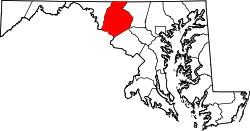
Garfield, Maryland

Last updated
Garfield, Maryland
Unincorporated community
USA Maryland location map.svg
Red pog.svg
Garfield
Location in Maryland
Coordinates: 39°36′14″N77°31′19″W / 39.60389°N 77.52194°W / 39.60389; -77.52194
Country United States
State Maryland
County Frederick
Elevation
[1]
1,453 ft (443 m)
Time zone UTC-5 (Eastern (EST))
  Summer (DST) UTC-4 (EDT)
FIPS code 04-31450
GNIS feature ID590278 [1]

Garfield is an unincorporated community in Frederick County, Maryland, United States, situated within the District 6, Catoctin.

Garfield appears on the Myersville U.S. Geological Survey Map and is located in the Eastern Time Zone. [2]

Garfield United Methodist Church

Garfield United Methodist Church is located on Stottlemeyer Road. Garfield United Methodist Church in Garfield, Maryland.jpg
Garfield United Methodist Church is located on Stottlemeyer Road.

One of the few structures in Garfield is the Garfield United Methodist Church. It is relatively small and is located on Stottlemeyer Road. [3]

Related Research Articles

<span class="mw-page-title-main">Frederick County, Maryland</span> County in Maryland, United States

Frederick County is located in Maryland, United States. As of the 2020 U.S. census, the population was 271,717. The county seat is Frederick.

<span class="mw-page-title-main">Frederick, Maryland</span> City in Maryland, United States

Frederick is a city in, and the county seat of, Frederick County, Maryland, United States. It is located at an important crossroads at the intersection of a major north–south Native American trail and east–west routes to the Chesapeake Bay, both at Baltimore and what became Washington, D.C., and across the Appalachian mountains to the Ohio River watershed. Frederick's population was 78,171 people as of the 2020 census, making it the second-largest incorporated city in Maryland behind Baltimore. It is a part of the Washington metropolitan area and the greater Washington–Baltimore combined statistical area.

Gainesboro is an unincorporated community in Frederick County, Virginia. Gainesboro is located northwest of Winchester off the North Frederick Pike on Gainesboro Road. Gainesboro is the northernmost community in Virginia.

<span class="mw-page-title-main">Maryland Route 355</span> State highway in Montgomery and Frederick Counties, Maryland, United States

Maryland Route 355 (MD 355) is a 36.75-mile (59.14 km) north–south road in western central Maryland in the United States. The southern terminus of the route is in Bethesda in Montgomery County, where Wisconsin Avenue meets the county's border with Washington, D.C. The northern terminus is just north of a bridge over Interstate 70 (I-70)/U.S. Route 40 (US 40) in the city of Frederick in Frederick County, where the road continues north as Market Street through Frederick towards MD 26.

<span class="mw-page-title-main">Buckeystown, Maryland</span> Census-designated place in Maryland, United States

Buckeystown is an unincorporated community and census-designated place (CDP) in Frederick County, Maryland, United States. As of the 2010 census the population was 1,019. Buckeystown Historic District and Buckingham House and Industrial School Complex were listed on the National Register of Historic Places in 1982. Carrollton Manor was listed in 1997. Former Congressman Roscoe Bartlett lives on a farm in the town.

<span class="mw-page-title-main">Maryland Route 85</span> State highway in Frederick County, Maryland, US, known as Buckeystown Pike

Maryland Route 85 is a state highway in the U.S. state of Maryland. Known as Buckeystown Pike, the state highway runs 10.80 miles (17.38 km) from MD 28 in Tuscarora north to the Frederick city limit north of Interstate 70 (I-70), where the highway continues north as East Street. MD 85 connects Tuscarora and Buckeystown in southern Frederick County with the county seat of Frederick. The state highway also links the suburban area between Buckeystown and Frederick with I-70 and I-270. MD 85 is the old alignment of U.S. Route 15, which was originally constructed between Tuscarora and Frederick in the late 1910s and early 1920s. MD 85 was assigned to the highway in 1970 when US 15 was moved to a new highway heading north from its Potomac River crossing at Point of Rocks. The state highway was extended north to the city of Frederick as part of a project to overhaul MD 355's interchange with I-70 in the first decade of the 21st century.

<span class="mw-page-title-main">Abingdon, Maryland</span> Census-designated place in Maryland

Abingdon is a census-designated place in Harford County, Maryland, United States. It lies 25 miles (40 km) northeast of Baltimore on Maryland Route 7, near the Bush River, between Exits 77 and 80 of Interstate 95.

<span class="mw-page-title-main">Triadelphia Reservoir</span> Reservoir in near Brookeville, Maryland

Triadelphia Reservoir is located on the Patuxent River, in Howard County and Montgomery County, Maryland near the town of Brookeville.

<span class="mw-page-title-main">Johnsville, Maryland</span> Unincorporated community in Maryland, U.S.

Johnsville is an unincorporated community in Frederick County, Maryland, United States. It is located approximately halfway between Libertytown and Union Bridge along Maryland Route 75. The Kitterman-Buckey Farm was listed on the National Register of Historic Places in 2005.

<span class="mw-page-title-main">Sabillasville, Maryland</span> Census-designated place in Maryland

Sabillasville is an unincorporated community and census-designated place in Frederick County, Maryland, United States. As of the 2010 census it had a population of 354.

Friendship is an unincorporated community and census-designated place (CDP) in Anne Arundel County, Maryland, United States. As of the 2010 census, its population was 447.

<span class="mw-page-title-main">Knoxville, Maryland</span> Unincorporated community in Maryland

Knoxville is an unincorporated community in Frederick and Washington counties, Maryland, United States. The Robert Clagett Farm and Magnolia Plantation are listed on the National Register of Historic Places.

<span class="mw-page-title-main">Detour, Maryland</span> Unincorporated community in Maryland, United States

Detour is an unincorporated community in Carroll County, Maryland, United States.

<span class="mw-page-title-main">Ijamsville, Maryland</span> Unincorporated community in Maryland, United States

Ijamsville is an unincorporated community located 7 miles (11 km) southeast of Frederick, in Frederick County, Maryland, United States. The town was founded by Plummer Ijams, a descendant of Welsh immigrants, from whom the town took its name. The discovery of high-quality slate in the area led to Ijamsville's brief era as a mining town, which lasted until it transitioned to agriculture in the mid-1800s. In the mid-to-late 20th century, large quantities of land in Ijamsville were purchased by developers, and the town became primarily residential as a suburb of Frederick, Baltimore, and D.C.

Whitesville is an unincorporated community in Sussex County, Delaware, United States. Whitesville is located just north of the stateline with Maryland. between Delmar and Selbyville. Local folklore ascribes the name to Ezekiel Williams, who built the first house in the village. It is the site of the Line United Methodist Church.

<span class="mw-page-title-main">Foxville, Maryland</span> Unincorporated community in Maryland, United States

Foxville is an unincorporated community in Frederick County, Maryland, United States. Foxville is located on Maryland Route 77, 4.7 miles (7.6 km) west of Thurmont. Settled in the late 18th century, the historic village is situated between South Mountain to the west and Catoctin Mountain to the east. Catoctin Mountain Park, Cunningham Falls State Park, and the Appalachian Trail are all within a few miles of Foxville.

New Market West is a suburban housing community in Frederick County, in the U.S. state of Maryland. The community is located in the foothills of the Blue Ridge Mountains and is adjacent to the town of New Market.

Garfield is an unincorporated community in Coal Township, Jackson County, Ohio, United States. It is located just north of Coalton on Sour Run Road, at 39°07′25″N82°37′12″W.

References

  1. 1 2 U.S. Geological Survey Geographic Names Information System: Garfield, Maryland
  2. "Garfield Populated Place Profile / Frederick County, Maryland Data". maryland.hometownlocator.com. Retrieved 2016-01-24.
  3. "Garfield United Methodist Chr in Smithsburg , MD". YP.com. Retrieved 2016-01-24.