Unionville, Frederick County, Maryland

Last updated

Unionville, Maryland
Richard S. Foster 43.jpg
USA Maryland location map.svg
Red pog.svg
Unionville
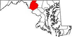
Location in Maryland
Coordinates: 39°28′29″N77°11′08″W / 39.47472°N 77.18556°W / 39.47472; -77.18556 [1]
Country United States
State Maryland
County Frederick
Elevation
[1]
440 ft (130 m)
GNIS feature ID591457 [1]

Unionville is an unincorporated community in Frederick County, Maryland, United States. [1] It is located approximately halfway between Frederick and Westminster, just east of Libertytown off Maryland Route 26 (Liberty Road). The Pearre-Metcalfe House, which sits on Albaugh Road, just outside the town's center, was listed on the National Register of Historic Places in 1979. [2]

Unionville holds the world record for most rainfall recorded in one minute. On July 4, 1956, 1.23 inches of rain fell in one minute. [3]

Related Research Articles

<span class="mw-page-title-main">Prince Frederick, Maryland</span> Census-designated place in Maryland, United States

Prince Frederick is an unincorporated community and census-designated place (CDP) in Calvert County, Maryland, United States. As of the 2020 census, the population of Prince Frederick was 3,226, up from 2,538 in 2010. It is the county seat of Calvert County.

<span class="mw-page-title-main">National Register of Historic Places listings in Maryland</span>

There are more than 1,500 properties and districts listed on the National Register of Historic Places in the U.S. State of Maryland. Each of the state's 23 counties and its one county-equivalent has at least 20 listings on the National Register.

<span class="mw-page-title-main">Unionville, Chester County, Pennsylvania</span> Census-designated place in Pennsylvania, United States

Unionville is an unincorporated community and census-designated place in East Marlborough Township in southern Chester County, Pennsylvania, United States. It was originally known as Jacksonville. The Unionville Village Historic District was added to the National Register of Historic Places in 1979. As of 2020, the CDP has a population of 577.

<span class="mw-page-title-main">Maryland Route 31</span> State highway in Maryland, US

Maryland Route 31 is a state highway in the U.S. state of Maryland. Known for most of its length as New Windsor Road, the state highway runs 16.95 miles (27.28 km) from MD 26 in Libertytown east to MD 140 in Westminster. MD 31 connects the county seats of Frederick and Westminster via Libertytown in eastern Frederick County and New Windsor in western Carroll County. MD 31 originally extended from Frederick to Manchester, using the paths of what are now MD 26 and MD 27. MD 26 assumed MD 31 west of Libertytown in 1933 and MD 27 took over MD 31's route north of Westminster in 1967. The Westminster–Manchester portion of the state highway was constructed as one of the original state roads in the early 1910s. The remainder of the highway was built in the early to mid-1920s. MD 31 was relocated north of Westminster in the late 1950s and south of Westminster in the mid-1960s. The bypassed sections of the state highway became parts of MD 852.

<span class="mw-page-title-main">Maryland Route 26</span> State highway in Maryland, US

Maryland Route 26 is a state highway in the U.S. state of Maryland. Known for most of its length as Liberty Road, the state highway runs 44.10 miles (70.97 km) from U.S. Route 15 in Frederick east to MD 140 in Baltimore. MD 26 connects Frederick and Baltimore with the highway's namesake of Libertytown in eastern Frederick County, the suburban area of Eldersburg in southern Carroll County, and the western Baltimore County suburbs of Randallstown, Milford Mill, and Lochearn. The highway also serves as a major thoroughfare in the western part of Baltimore, where the street is named Liberty Heights Avenue. MD 26 is maintained by the Maryland State Highway Administration outside of Baltimore and by the Baltimore City Department of Transportation within the city.

<span class="mw-page-title-main">Wye House</span> Historic house in Maryland, United States

Wye House is a historic residence and former headquarters of a historic plantation house northwest of Easton in rural Talbot County, Maryland. Built in 1781–1784, it is a high-quality and well-proportioned example of a wooden-frame Southern plantation house. It was designated a National Historic Landmark in 1970.

<span class="mw-page-title-main">Sudbrook Park</span> Historic district in Maryland, United States

Sudbrook Park is a historic neighborhood near Pikesville, Maryland located just northwest of the Baltimore City limits in Baltimore County.

Port Republic is a small, rural unincorporated community located at the crossroads of MD routes 2/MD 4, MD 264, MD 509, MD 765, and Parkers Creek Road in Calvert County, Maryland, United States. It is approximately five miles south of Prince Frederick, the county seat of Calvert County.

Barstow is a small, rural unincorporated community located at the crossroads of MD 231, German Chapel Road, and Barstow Road in Calvert County, Maryland, United States, immediately west of Prince Frederick. The community maintains its own zip code of 20610.

<span class="mw-page-title-main">Poffenberger Road Bridge</span> United States historic place

The Poffenberger Road Bridge, near Jefferson, Maryland, is a wrought iron bridge by the Wrought Iron Bridge Company of Canton, Ohio. The bridge is similar to the Fourpoints Bridge elsewhere in Frederick County. The bridge is a single-span double-intersection Pratt truss. It was built circa 1878 and remains in daily use.

<span class="mw-page-title-main">National Register of Historic Places listings in Frederick County, Maryland</span>

This is a list of the National Register of Historic Places listings in Frederick County, Maryland.

<span class="mw-page-title-main">Nolands Ferry I Archeological Site</span> United States historic place

Nolands Ferry I Archeological Site is an archaeological site near the historic Noland's Ferry boat landing at mile 44.58 on the C&O Canal and Tuscarora. The Archeological Site is a prehistoric occupation site located in the Monocacy region of southern Frederick County, Maryland. Diagnostic artifacts at the site indicate that the site was almost continuously inhabited from the Paleo-Indian period to the early 19th century, with the most substantial inhabitation occurring during the Late Woodland period.

<span class="mw-page-title-main">Old Mill Road Bridge</span> United States historic place

The Old Mill Road Bridge is a historic bridge near Rocky Ridge, Frederick County, Maryland, United States. The bridge spans Owens Creek southwest of Rocky Ridge on Old Mill Road. It is a Pratt half-hip through truss structure in a single span 69 feet (21 m) long and 16 feet (4.9 m). It was built in 1882 by the Pittsburgh Bridge Company, Pittsburgh, Pennsylvania.

<span class="mw-page-title-main">Roddy Road Covered Bridge</span> United States historic place

The Roddy Road Covered Bridge is a small, one lane king post wooden covered bridge near Thurmont, Frederick County, Maryland. It crosses Owen's Creek near Thurmont. It is 40 feet long, 16 feet wide, with a 12 foot-8 inch clearance. It was built between 1850 and 1860.

<span class="mw-page-title-main">Crum Road Bridge</span> United States historic place

The Crum Road Bridge is a historic bridge near Frederick, Frederick County, Maryland, United States. It spanned Israel Creek southeast of Walkersville. The bridge is an iron bowstring pony bridge that is 62 feet (19 m) in length and 15.8 feet (4.8 m) in width. The Crum Road Bridge was built on or about 1875, and was probably constructed by the King Iron Bridge Company of Cleveland, Ohio.

<span class="mw-page-title-main">Creagerstown, Maryland</span> Unincorporated community in Maryland, United States

Creagerstown is an unincorporated community in Frederick County, Maryland, United States. It is playfully known by its residents as "4 miles from everywhere" because of its situation at 4 miles (6.4 km) from Thurmont, Woodsboro, Rocky Ridge, and Lewistown.

<span class="mw-page-title-main">Johnsville, Maryland</span> Unincorporated community in Maryland, U.S.

Johnsville is an unincorporated community in Frederick County, Maryland, United States. It is located approximately halfway between Libertytown and Union Bridge along Maryland Route 75. The Kitterman-Buckey Farm was listed on the National Register of Historic Places in 2005.

<span class="mw-page-title-main">Libertytown, Maryland</span> Census-designated place in Maryland, United States

Libertytown is an unincorporated community and census-designated place (CDP) in Frederick County, in the U.S. state of Maryland. As of the 2010 census it had a population of 950. The Abraham Jones House was listed on the National Register of Historic Places in 1973.

<span class="mw-page-title-main">Knoxville, Maryland</span> Unincorporated community in Maryland

Knoxville is an unincorporated community in Frederick and Washington counties, Maryland, United States. The Robert Clagett Farm and Magnolia Plantation are listed on the National Register of Historic Places.

<span class="mw-page-title-main">Maryland Route 550</span> State highway in Maryland, United States

Maryland Route 550 is a state highway in the U.S. state of Maryland. The state highway runs 24.43 miles (39.32 km) from MD 26 in Libertytown north to Pen Mar Road in Fort Ritchie. MD 550 runs southeast–northwest across central Frederick County, connecting Fort Ritchie in the northeastern corner of Washington County and Libertytown with the towns of Thurmont and Woodsboro and the smaller communities of Creagerstown and Sabillasville. South of the highway's junction with U.S. Route 15 in Thurmont, the state highway passes through the wide valley of the Monocacy River; to the north, the highway passes along the northern edge of Catoctin Mountain and crests South Mountain near Blue Ridge Summit, Pennsylvania.

References

  1. 1 2 3 4 U.S. Geological Survey Geographic Names Information System: Unionville, Frederick County, Maryland
  2. "National Register Information System". National Register of Historic Places . National Park Service. April 15, 2008.
  3. "America's Heaviest Rainfall Records". The Weather Channel. Retrieved August 27, 2017.