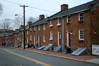
Oella is a mill town on the Patapsco River in western Baltimore County, Maryland, United States, located between Catonsville and Ellicott City. It is a 19th-century village of millworkers' homes.
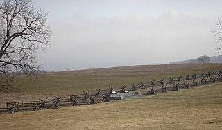
Antietam National Battlefield is a National Park Service-protected area along Antietam Creek in Sharpsburg, Washington County, northwestern Maryland. It commemorates the American Civil War Battle of Antietam that occurred on September 17, 1862.

St. Charles College was a minor seminary in Catonsville, Maryland, originally located in Ellicott City, Maryland.

Begun in 1898 in rural Frederick County, Maryland, the LeGore Bridge was completed and opened to the public in 1900. It was built and maintained by the owners of the LeGore Lime Company, including local businessman James William LeGore and his company advisor, Eugene Hammond. It is 340 feet (100 m) in length, 27 feet (8.2 m) wide and 64 feet (20 m) high. The bridge is situated at 39°35'N 77°19'W. The five arch limestone bridge was restored in 1981 and 2009.

The Buckeystown Historic District includes the majority of the small town of Buckeystown, Maryland, an unincorporated community located in Frederick County, Maryland, USA. It is named for George Buckey, a tanner, and his brother, John Buckey, a blacksmith and tavern owner. Buckeystown is on the U.S National Register of Historic Places and the Maryland Civil War Trail due to its rich history and beautiful examples of Queen Anne and Victorian style houses, along with a small commercial center. Each historic home has a plaque indicating the year built, the earliest being circa 1780. There are also several historical information plaques installed along the main street.

The Buckingham House and Industrial School Complex is a historic trade school complex located near Buckeystown, Frederick County, Maryland. It consists of thirteen buildings associated with a trade school for boys from poor families that operated from 1898 to 1944. The complex centers on a 3-story dormitory building built for the school, but also includes the late 18th-century Federal style Buckingham House. The surrounding farm was, uniquely for the area, irrigated. Bordering the Monocacy River, the grounds include several significant late Woodland period archeological sites.
The Martins Pond Archeological Site is an archaeological site near Annapolis in Anne Arundel County, Maryland. It is a Middle-Late Woodland period site, with lithic, floral, and faunal remains.
Barton Village Site, also known as the Herman Barton Indian Village Archeological Site, is a large, multi-component archaeological site near Cumberland in Allegany County, Maryland.

Nolands Ferry I Archeological Site is an archaeological site near the historic Noland's Ferry boat landing at mile 44.58 on the C&O Canal and Tuscarora. The Archeological Site is a prehistoric occupation site located in the Monocacy region of southern Frederick County, Maryland. Diagnostic artifacts at the site indicate that the site was almost continuously inhabited from the Paleo-Indian period to the early 19th century, with the most substantial inhabitation occurring during the Late Woodland period.
Shoemaker III Village Site is an archaeological site near Emmitsburg, in the extreme northern section of Frederick County, Maryland. Pottery fragments, projectile points, and other artifacts found at the site date it to 900–1300.

Johnsville is an unincorporated community in Frederick County, Maryland, United States. It is located approximately halfway between Libertytown and Union Bridge along Maryland Route 75. The Kitterman-Buckey Farm was listed on the National Register of Historic Places in 2005.
Whiteford is an unincorporated community in Harford County, Maryland, United States. The community has historically had a strong Welsh heritage, which is reflected in the local architecture.

Beallsville is an unincorporated community in Montgomery County, Maryland, United States. It is a small community located north of Poolesville. The ZIP Code for Beallsville is 20839.

Samples Manor is an unincorporated community in Washington County, Maryland, United States. The Kennedy Farm was listed on the National Register of Historic Places in 1973.

Maryland Route 550 is a state highway in the U.S. state of Maryland. The state highway runs 24.43 miles (39.32 km) from MD 26 in Libertytown north to Pen Mar Road in Fort Ritchie. MD 550 runs southeast–northwest across central Frederick County, connecting Fort Ritchie in the northeastern corner of Washington County and Libertytown with the towns of Thurmont and Woodsboro and the smaller communities of Creagerstown and Sabillasville. South of the highway's junction with U.S. Route 15 in Thurmont, the state highway passes through the wide valley of the Monocacy River; to the north, the highway passes along the northern edge of Catoctin Mountain and crests South Mountain near Blue Ridge Summit, Pennsylvania.

St. John's Lutheran Church, founded in 1770, is a historic Lutheran church located at 141 South Potomac Street in the South end of the arts and entertainment district of Hagerstown, Maryland.
Daisy is an unincorporated community located at the northwest tip of Howard County, Maryland, United States.
The Rosenstock Village site is a historic site located in Frederick County, Maryland, United States, near the city of Frederick. It contains the remains of a Late Woodland Village situated on a bluff overlooking the Monocacy River. The village was occupied between A.D. 1335 and A.D. 1400, based on artifact analysis and radiocarbon dating. It is similar to the Montgomery Complex, which is a cultural complex made up of Late Woodland sites located on the Potomac River. The site was excavated in 1979 and from 1990 to 1992, and estimates suggest that 93% of the site remains undisturbed. They uncovered a large oval area surrounded by pits, a large sheet midden area, and what are believed to be two sweatlodges. The excavations have yielded a trove of artifacts and animal remains. The site was listed on the National Register of Historic Places in 2018.
Pen Mar is an unincorporated community in Washington County, Maryland, and Franklin County, Pennsylvania, United States. It is one of the border towns in the United States with a portmanteau name. Pen Mar came to prominence as a resort in the 20th century after the construction of Pen Mar Park by the Western Maryland Railway. While the resort has long been dismantled, the area still has some significance in Maryland, since it is the northern starting point for the Maryland section of the Appalachian Trail.

Harmony Grove is a ghost town located close to U.S. Route 15, north of Frederick (city) in Frederick County, Maryland. Harmony Grove is considered part of the Piedmont region of Maryland.


