Harrisville, West Virginia

Last updated

Harrisville, West Virginia
Harrisville West Virginia.jpg
Main Street in Harrisville in 2007
Flag of Harrisville, West Virginia.svg
Ritchie County West Virginia Incorporated and Unincorporated areas Harrisville Highlighted.svg
Location of Harrisville in Ritchie County, West Virginia.
Coordinates: 39°12′36″N81°3′3″W / 39.21000°N 81.05083°W / 39.21000; -81.05083
Country United States
State West Virginia
County Ritchie
Area
[1]
  Total1.59 sq mi (4.13 km2)
  Land1.58 sq mi (4.10 km2)
  Water0.01 sq mi (0.03 km2)
Elevation
856 ft (261 m)
Population
 (2020) [2]
  Total1,661
  Estimate 
(2021) [2]
1,642
  Density1,056.82/sq mi (408.08/km2)
Time zone UTC−5 (Eastern (EST))
  Summer (DST) UTC−4 (EDT)
ZIP Code
26362
Area code 304
FIPS code 54-35428 [3]
GNIS feature ID1540017 [4]
Website https://cityofharrisville.wixsite.com/mysite

Harrisville is a town and the county seat of Ritchie County, West Virginia, United States. [5] Harrisville is located at the junction of State Routes 31 and 16, five miles south of U.S. 50. Within the community are an elementary school, the county board of education, many businesses, three banks, a library, offices of the Ritchie Gazette and The Pennsboro News, a municipal park, and North Bend Golf Course. North Bend Lake and North Bend State Park are located just outside town limits. Municipal elections are held every two years. [6]

Contents

History

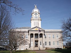
The town was laid out in 1822 by Thomas Harris, who had moved his family there in 1807. The town was chartered in 1832, and the first post office opened in 1833, under the name Solus. The name was later changed to Ritchie Court House, and then changed again to Harrisville in 1895, when the town was named for Gen. Thomas Harris, [7] [8] nephew of the founder. Ritchie County was formed in 1843, and the first courthouse was built in 1844. It was replaced by a brick structure in 1874. The present courthouse, a Harrisville landmark, was completed in late 1923.

The Pennsboro & Harrisville Railroad was built in 1875, operating between the two communities of its name. The broad-gauge Harrisville Southern Railroad ran to Cornwallis between about 1909 and 1929. [9]

Harrisville High School was established on the west end of town in 1894. That structure now houses the General Thomas M. Harris School Museum. A new school built overlooking Harrisville in 1924 served as Harrisville High School until 1986. The same school building served as Ritchie County High School until it was closed in 1994. The school building was demolished on December 16, 2017. A small portion of the original school building remains and is the headquarters of “Ritchie Regional Health Center.” The Harrisville High School gym still remains and is now a community workout center using the name "The Gym," restored by the Harrisville First Assembly of God using funds generated from grants, memberships and donations. [10]

General Harris, Harrisville's most distinguished citizen, died there in 1906. A medical doctor, Union officer and state adjutant general (1869-1871), he served on the military commission that tried the conspirators responsible for the assassination of Abraham Lincoln. His son, John T. Harris, long-time clerk of the state Senate, founded the West Virginia Blue Book in 1916. The Harrisville Historic District was listed on the National Register of Historic Places in 2011. [6]

The Harrisville Historic District, Harrisville Grade School, and the Ritchie County Courthouse are listed on the National Register of Historic Places. [11] [12]

The town is home to historic Berdine's Five and Dime.

Notable person

Frank Deem (1928-2018), West Virginia state legislator and engineer, was born in Harrisville. [13]

Geography

Harrisville is located at 39°12′36″N81°3′3″W / 39.21000°N 81.05083°W / 39.21000; -81.05083 (39.209866, -81.050917). [14]

According to the United States Census Bureau, the town has a total area of 1.59 square miles (4.12 km2), of which 1.58 square miles (4.09 km2) is land and 0.01 square miles (0.03 km2) is water. [15]

Demographics

Historical population
CensusPop.Note
1870 140
1880 22157.9%
1890 36163.3%
1900 47230.7%
1910 60828.8%
1920 1,03670.4%
1930 1,19215.1%
1940 1,33812.2%
1950 1,3873.7%
1960 1,4283.0%
1970 1,4642.5%
1980 1,67314.3%
1990 1,8399.9%
2000 1,8420.2%
2010 1,8761.8%
2020 1,661−11.5%
2021 (est.)1,642 [2] −1.1%
U.S. Decennial Census [16]

2010 census

According to the 2010 census, [17] there were 1,876 people, 787 households, and 496 families living in the town. The population density was 1,187.3 inhabitants per square mile (458.4/km2). There were 917 housing units at an average density of 580.4 per square mile (224.1/km2). The racial makeup of the town was 98.6% White, 0.3% African American, 0.1% Native American, 0.3% Asian, 0.2% from other races, and 0.6% from two or more races. Hispanic or Latino of any race were 0.7% of the population.

There were 787 households, of which 29.2% had children under the age of 18 living with them, 48.0% were married couples living together, 10.9% had a female householder with no husband present, 4.1% had a male householder with no wife present, and 37.0% were non-families. 32.9% of all households were made up of individuals, and 13.2% had someone living alone who was 65 years of age or older. The average household size was 2.25 and the average family size was 2.81.

The median age in the town was 44.8 years. 21.3% of residents were under the age of 18; 5.7% were between the ages of 18 and 24; 23.3% were from 25 to 44; 28.1% were from 45 to 64; and 21.6% were 65 years of age or older. The gender makeup of the town was 46.2% male and 53.8% female.

2000 census

As of the census [3] of 2000, there were 1,842 people, 780 households, and 516 families living in the town. The population density was 1,120.0 inhabitants per square mile (433.7/km2). There were 889 housing units at an average density of 540.6 per square mile (209.3/km2). The racial makeup of the town was 98.59% White, 0.05% African American, 0.05% Native American, 0.22% Asian, 0.33% from other races, and 0.76% from two or more races. Hispanic or Latino of any race were 0.76% of the population.

The Ritchie County Courthouse in Harrisville in 2007 Ritchie County Courthouse.jpg
The Ritchie County Courthouse in Harrisville in 2007

There were 780 households, out of which 27.1% had children under the age of 18 living with them, 51.3% were married couples living together, 11.2% had a female householder with no husband present, and 33.8% were non-families. 30.6% of all households were made up of individuals, and 15.6% had someone living alone who was 65 years of age or older. The average household size was 2.26 and the average family size was 2.80.

In the town, the population was spread out, with 20.3% under the age of 18, 7.4% from 18 to 24, 29.3% from 25 to 44, 23.8% from 45 to 64, and 19.3% who were 65 years of age or older. The median age was 40 years. For every 100 females, there were 90.7 males. For every 100 females age 18 and over, there were 86.5 males.

The median income for a household in the town was $28,750, and the median income for a family was $38,083. Males had a median income of $27,200 versus $20,040 for females. The per capita income for the town was $15,158. About 17.5% of families and 22.4% of the population were below the poverty line, including 31.6% of those under age 18 and 15.2% of those age 65 or over.

Related Research Articles

<span class="mw-page-title-main">Wirt County, West Virginia</span> County in West Virginia, United States

Wirt County is a county in the U.S. state of West Virginia. As of the 2020 census, the population was 5,194, making it the least populous county in West Virginia. Its county seat is Elizabeth. The county was created in 1848 by the Virginia General Assembly and named for U.S. Attorney General and presidential candidate William Wirt. The county is served by one high school, Wirt County High School.

<span class="mw-page-title-main">Ritchie County, West Virginia</span> County in West Virginia, United States

Ritchie County is a county in the U.S. state of West Virginia. As of the 2020 census, the population was 8,444. Its county seat is Harrisville. The county was created in 1843 by the Virginia General Assembly and named for Richmond newspaper publisher Thomas Ritchie.

<span class="mw-page-title-main">Osceola, Indiana</span> Town in Indiana, United States

Osceola is a town in Penn Township, St. Joseph County, in the U.S. state of Indiana. The population was 2,463 at the 2010 Census. It is part of the South Bend–Mishawaka, IN-MI, Metropolitan Statistical Area.

<span class="mw-page-title-main">Harris, Kansas</span> Unincorporated community in Anderson County, Kansas

Harris is an unincorporated community in Anderson County, Kansas, United States. As of the 2020 census, the population of the community and nearby areas was 47.

<span class="mw-page-title-main">Harrisville, Michigan</span> City in Michigan, United States

Harrisville is a city in the U.S. state of Michigan and the county seat of Alcona County. The population was 437 at the 2020 census, making Harrisville the sixth-smallest city by population in the state of Michigan. The city is surrounded by Harrisville Township but is administratively autonomous. Located on Lake Huron, it is an official Michigan Department of Natural Resources Harbor of Refuge.

<span class="mw-page-title-main">Harrisville Township, Michigan</span> Civil township in Michigan, United States

Harrisville Township is a civil township of Alcona County in the U.S. state of Michigan. The population was 1,307 at the 2020 census. Harrisville Township surrounds the city of Harrisville, but the two are administered autonomously.

<span class="mw-page-title-main">Harrisville, New Hampshire</span> Town in New Hampshire, United States

Harrisville is a town in Cheshire County, New Hampshire, United States. Besides the town center, it also includes the villages of Chesham and Eastview. The population of the town was 984 at the 2020 census.

Diana is a town in Lewis County, New York, United States. The population was 1,709 at the 2010 census. The town is on the northeastern border of the county and is located northeast of Watertown. The northwestern section of Diana is in the Fort Drum military reservation.

Harrisville is a hamlet and former village in Lewis County, New York, United States. The community is now a census-designated place. The population was 628 at the 2010 census.

<span class="mw-page-title-main">Wintersville, Ohio</span> Village in Ohio, United States

Wintersville is a village in central Jefferson County, Ohio. The population was 3,609 as of the 2020 Census. It is part of the Weirton–Steubenville metropolitan area. The village is suburban in nature and is governed by a mayor and council elected by non-partisan ballot.

<span class="mw-page-title-main">Lodi, Ohio</span> Village in Ohio, United States

Lodi is a village in Harrisville Township, Medina County, Ohio, United States. It is located southwest of the City of Medina along U.S. Route 42. As of the 2020 census, the population was 2,746.

<span class="mw-page-title-main">Harrisville, Pennsylvania</span> Borough in Pennsylvania, United States

Harrisville is a borough in Butler County, Pennsylvania, United States. The population was 897 at the 2010 census.

<span class="mw-page-title-main">West Pennsboro Township, Pennsylvania</span> Township in Pennsylvania, United States

West Pennsboro Township is a township that is located in Cumberland County, Pennsylvania, United States. The population was 5,561 at the time of the 2010 census.

<span class="mw-page-title-main">Wormleysburg, Pennsylvania</span> Borough in Pennsylvania, United States

Wormleysburg is a borough in Cumberland County, Pennsylvania, United States. The population was 3,070 at the 2010 census. It is part of the Harrisburg–Carlisle Metropolitan Statistical Area.

<span class="mw-page-title-main">Burrillville, Rhode Island</span> Town in Rhode Island, United States

Burrillville is a town in Providence County, Rhode Island, United States. The population was 16,158 at the 2020 census.

<span class="mw-page-title-main">Harrisville, Rhode Island</span> Census-designated place in Rhode Island, United States

Harrisville is a census-designated place (CDP) and village in the town of Burrillville in Providence County, Rhode Island, United States. The population was 1,605 at the 2010 census. Much of the community composes a historic district listed on the National Register of Historic Places. The village was named after nineteenth century manufacturer Andrew Harris. Previously, the village was named Rhodesville, after Captain William Rhodes, an eighteenth century privateer.

<span class="mw-page-title-main">Trenton, South Carolina</span> Town in South Carolina, United States

Trenton is a town in Edgefield County, South Carolina, United States. The population was 196 at the 2010 census, down from 226 in 2000.

<span class="mw-page-title-main">Harrisville, Utah</span> City in Utah, United States

Harrisville is a city in Weber County, Utah, United States. The population was 5,567 at the 2010 census. It is part of the Ogden–Clearfield, Utah Metropolitan Statistical Area. The current mayor is Michelle Tait.

<span class="mw-page-title-main">Pennsboro, West Virginia</span> City in West Virginia, United States

Pennsboro is a city in Ritchie County, West Virginia, United States. The population was 1,050 at the 2020 census. The city is located at the junction of U.S. Route 50 and West Virginia Route 74; the North Bend Rail Trail also passes through the city.

<span class="mw-page-title-main">Harris, Wisconsin</span> Town in Wisconsin, United States

Harris is a town located in Marquette County, Wisconsin. According to the 2000 census, the town had a total population of 729. The unincorporated community of Harrisville is located in the town. Both the community and the town were named for James Harris, who became the first postmaster when the community's post office opened in March 1851. The village of Westfield is adjacent to the town.

References

  1. "2019 U.S. Gazetteer Files". United States Census Bureau. Retrieved August 7, 2020.
  2. 1 2 3 Bureau, US Census. "City and Town Population Totals: 2020-2021". Census.gov. US Census Bureau. Retrieved July 3, 2022.
  3. 1 2 "U.S. Census website". United States Census Bureau . Retrieved January 31, 2008.
  4. "US Board on Geographic Names". United States Geological Survey. October 25, 2007. Retrieved January 31, 2008.
  5. "Find a County". National Association of Counties. Retrieved June 7, 2011.
  6. 1 2 "E-WV | Harrisville".
  7. "Harrisville, West Virginia - West Virginia (WV) Cyclopedia". Archived from the original on September 23, 2019. Retrieved September 23, 2019.
  8. Gannett, Henry (1905). The Origin of Certain Place Names in the United States. Govt. Print. Off. pp.  151.
  9. http://www.rlhssec.org/pdfs/SEL1412.pdf [ bare URL PDF ]
  10. https://www.facebook.com/pg/The-Gym-in-Harrisville-186076728151989/about/?ref=page_internal [ user-generated source ]
  11. "National Register Information System". National Register of Historic Places . National Park Service. July 9, 2010.
  12. "National Register of Historic Places Listings". Weekly List of Actions Taken on Properties: 8/15/11 through 8/19/11. National Park Service. August 26, 2011.
  13. 'Delegate Frank Deem, 48th legislative veteran, does at age 90,' Charleston Gazette-Mail, Phil Kabler, October 10, 2018
  14. "US Gazetteer files: 2010, 2000, and 1990". United States Census Bureau. February 12, 2011. Retrieved April 23, 2011.
  15. "US Gazetteer files 2010". United States Census Bureau . Retrieved January 24, 2013.
  16. "Census of Population and Housing". Census.gov. Retrieved June 4, 2015.
  17. "U.S. Census website". United States Census Bureau . Retrieved January 24, 2013.