Triadelphia, West Virginia

Last updated

Triadelphia, West Virginia
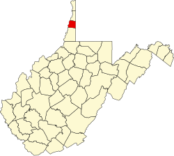
Ohio County West Virginia Incorporated and Unincorporated areas Triadelphia Highlighted.svg
Location of Triadelphia in Ohio County, West Virginia.
Coordinates: 40°3′3″N80°37′37″W / 40.05083°N 80.62694°W / 40.05083; -80.62694
Country United States
State West Virginia
County Ohio
Area
[1]
  Total0.68 sq mi (1.75 km2)
  Land0.67 sq mi (1.74 km2)
  Water0.00 sq mi (0.00 km2)
Elevation
741 ft (226 m)
Population
 (2020) [2]
  Total669
  Estimate 
(2021) [2]
659
  Density1,132.24/sq mi (437.29/km2)
Time zone UTC-5 (Eastern (EST))
  Summer (DST) UTC-4 (EDT)
ZIP code
26059
Area code 304
FIPS code 54-80932 [3]
GNIS feature ID1555822 [4]
Website local.wv.gov/triadelphia/Pages/default.aspx

Triadelphia is a town in Ohio County, West Virginia, United States. It is part of the Wheeling, West Virginia Metropolitan Statistical Area. The population was 669 at the 2020 census. [2]

Contents

History

Triadelphia was originally chartered in 1829. The name Triadelphia was adopted from the Greek words meaning three brothers, [5] and most likely was named in honor of the three sons of the original owner of the town site. [6]

It is home to the Highlands, the largest retail complex in the Northern Panhandle of West Virginia.

Located near Triadelphia is the David Stewart Farm, listed on the National Register of Historic Places in 1979. [7]

Geography

Triadelphia is located at 40°3′3″N80°37′37″W / 40.05083°N 80.62694°W / 40.05083; -80.62694 (40.050705, -80.627015), [8] along Little Wheeling Creek and Middle Wheeling Creek, which are tributaries of Wheeling Creek. [9]

According to the United States Census Bureau, the town has a total area of 0.67 square miles (1.74 km2), all land. [10]

Demographics

Historical population
CensusPop.Note
1850 242
1860 2586.6%
1870 239−7.4%
1880 31331.0%
1890 51564.5%
1900 287−44.3%
1910 261−9.1%
1920 29914.6%
1930 3021.0%
1940 35918.9%
1950 741106.4%
1960 600−19.0%
1970 547−8.8%
1980 1,461167.1%
1990 835−42.8%
2000 817−2.2%
2010 811−0.7%
2020 669−17.5%
2021 (est.)659 [2] −1.5%
U.S. Decennial Census [11]

2010 census

As of the census [12] of 2010, there were 811 people, 373 households, and 221 families living in the town. The population density was 1,210.4 inhabitants per square mile (467.3/km2). There were 402 housing units at an average density of 600.0 per square mile (231.7/km2). The racial makeup of the town was 95.1% White, 3.1% African American, 0.1% Asian, 0.1% from other races, and 1.6% from two or more races. Hispanic or Latino of any race were 1.0% of the population.

There were 373 households, of which 26.0% had children under the age of 18 living with them, 36.5% were married couples living together, 15.5% had a female householder with no husband present, 7.2% had a male householder with no wife present, and 40.8% were non-families. 34.0% of all households were made up of individuals, and 8.8% had someone living alone who was 65 years of age or older. The average household size was 2.17 and the average family size was 2.71.

The median age in the town was 40 years. 22.2% of residents were under the age of 18; 6.8% were between the ages of 18 and 24; 26.7% were from 25 to 44; 29.1% were from 45 to 64; and 15.3% were 65 years of age or older. The gender makeup of the town was 48.8% male and 51.2% female.

2000 census

As of the census [3] of 2000, there were 817 people, 370 households, and 223 families living in the town. The population density was 1,187.2 inhabitants per square mile (457.2/km2). There were 406 housing units at an average density of 590.0 per square mile (227.2/km2). The racial makeup of the town was 97.31% White, 1.59% African American, 0.12% Native American, and 0.98% from two or more races. Hispanic or Latino of any race were 0.73% of the population. 25.9% were of German, 13.4% Irish, 11.2% Italian, 9.3% Polish, 8.9% American and 7.0% English ancestry according to Census 2000.

There were 370 households, out of which 24.6% had children under the age of 18 living with them, 44.9% were married couples living together, 11.1% had a female householder with no husband present, and 39.7% were non-families. 35.1% of all households were made up of individuals, and 14.3% had someone living alone who was 65 years of age or older. The average household size was 2.21 and the average family size was 2.83.

In the town, the population was spread out, with 20.8% under the age of 18, 9.8% from 18 to 24, 29.7% from 25 to 44, 25.9% from 45 to 64, and 13.7% who were 65 years of age or older. The median age was 39 years. For every 100 females, there were 97.8 males. For every 100 females age 18 and over, there were 89.2 males.

The median income for a household in the town was $26,169, and the median income for a family was $36,136. Males had a median income of $25,441 versus $18,958 for females. The per capita income for the town was $14,267. About 15.8% of families and 15.8% of the population were below the poverty line, including 22.4% of those under age 18 and 6.0% of those age 65 or over.

Transportation and Infrastructure

Maple Tree Motor Court Maple Tree Motor Court, Triadelphia, West Virginia (85682).jpg
Maple Tree Motor Court

Many parts of Triadelphia are accessible through Interstate 70 or the slightly-farther Interstate 470. U.S. Route 40 (US 40) runs through the northeastern suburbs of Wheeling, Triadelphia and Valley Grove. A majority of the route, including the portion in Triadelphia, still follows the route of the old National Road, which antedates the U.S. Highway System.

No passenger rail travel exists today within Triadelphia.

Air travel is restricted to Pittsburgh International Airport as the closest and most accessible place for commercial airline service, while Wheeling Ohio County Airport is the primary general aviation airport for Triadelphia.

Health care (11.7%), Accommodation & food services (9.2%), Construction (8.9%), Administrative & support & waste management services (5.7%), Drugs, sundries, chemical & allied products merchant wholesalers (5.4%), Social assistance (4.9%), and Educational services (4.9%) are the most common industries in Triadelphia, WV ( percent ).

Related Research Articles

<span class="mw-page-title-main">Ohio County, West Virginia</span> County in West Virginia, United States

Ohio County is a county located in the Northern Panhandle of the U.S. state of West Virginia. As of the 2020 census, the population was 42,425. Its county seat is Wheeling. The county was formed in 1776 from the District of West Augusta, Virginia. It was named for the Ohio River, which forms its western boundary with the state of Ohio. West Liberty was designated as the county seat in 1777, serving to 1797.

<span class="mw-page-title-main">Logan County, West Virginia</span> County in West Virginia, United States

Logan County is a county in the U.S. state of West Virginia. As of the 2020 census, the population was 32,567. Its county seat is Logan. Logan County comprises the Logan, WV Micropolitan Statistical Area, which is also included in the Charleston–Huntington–Ashland, WV–OH–KY Combined Statistical Area.

<span class="mw-page-title-main">Indian Falls, California</span> Census-designated place in California, United States

Indian Falls is a census-designated place (CDP) in Plumas County, California, United States. The population was 10 at the 2020 census, down from 54 at the 2010 census.

<span class="mw-page-title-main">Benedict, Kansas</span> City in Wilson County, Kansas

Benedict is a city in Wilson County, Kansas, United States, along the Verdigris River. As of the 2020 census, the population of the city was 69.

<span class="mw-page-title-main">Wheeling, Missouri</span> City in Missouri, United States

Wheeling is a city in eastern Livingston County, Missouri, United States. The population was 220 at the 2020 census.

<span class="mw-page-title-main">Bridgeport, Ohio</span> Village in Ohio, United States

Bridgeport is a village in eastern Belmont County, Ohio, United States. It lies across the Ohio River from Wheeling, West Virginia, at the mouth of Wheeling Creek and is connected by two bridges to Wheeling Island. The population was 1,582 at the 2020 census. It is part of the Wheeling metropolitan area.

<span class="mw-page-title-main">Windsor Heights, West Virginia</span> Village in West Virginia, United States

Windsor Heights is a village in Brooke County, West Virginia, United States. It is part of the Wheeling, West Virginia Metropolitan Statistical Area. The population was 423 at the 2010 census. Grace Davis was the mayor as of June, 2017.

<span class="mw-page-title-main">Anmoore, West Virginia</span> Town in West Virginia, United States

Anmoore is a town in Harrison County, West Virginia, United States. It is located at the intersection of WV 58 and Interstate 79. The population was 514 at the 2020 census.

<span class="mw-page-title-main">West Milford, West Virginia</span> Town in West Virginia, United States

West Milford is a town in Harrison County, West Virginia, United States. The population was 452 at the 2020 census.

<span class="mw-page-title-main">Glen Dale, West Virginia</span> Town in West Virginia

Glen Dale is a city in Marshall County, West Virginia, United States, along the Ohio River. It is part of the Wheeling, West Virginia Metropolitan Statistical Area. The population was 1,514 at the 2020 census. Glen Dale was incorporated in 1924. It is in the northwest part of the county, which is above the Mason–Dixon line and forms the base of the Northern Panhandle of West Virginia.

<span class="mw-page-title-main">McMechen, West Virginia</span> City in West Virginia

McMechen is a city in Marshall County, West Virginia, United States, situated along the Ohio River. It is part of the Wheeling, West Virginia Metropolitan Statistical Area. The population was 1,714 at the 2020 census.

Cassville is a census-designated place (CDP) in Monongalia County, West Virginia, United States. The population was 1,268 at the 2020 census. It is included in the Morgantown, West Virginia Metropolitan Statistical Area. Cassville was named after Lewis Cass, a prominent American statesman who served as Secretary of War, Secretary of State, and Governor of Michigan.

<span class="mw-page-title-main">Peterstown, West Virginia</span> Town in West Virginia, United States

Peterstown is a town in Monroe County, West Virginia, United States. The population was 456 at the 2020 census.

<span class="mw-page-title-main">Bethlehem, West Virginia</span> Village in West Virginia, United States

Bethlehem is a village in Ohio County, West Virginia, United States. It is part of the Wheeling, West Virginia Metropolitan Statistical Area. The population was 2,499 at the 2010 census.

<span class="mw-page-title-main">Clearview, West Virginia</span> Village in West Virginia, United States

Clearview is a village in Ohio County, West Virginia, United States. It is part of the Wheeling, West Virginia Metropolitan Statistical Area. The population was 565 at the 2010 census.

<span class="mw-page-title-main">Valley Grove, West Virginia</span> Village in West Virginia, United States

Valley Grove is a village in Ohio County, West Virginia, United States. It is part of the Wheeling, West Virginia Metropolitan Statistical Area. The population was 378 at the 2010 census. The village was named from a nearby recreational area at a grove in a valley.

<span class="mw-page-title-main">West Liberty, West Virginia</span> Town in West Virginia, United States

West Liberty is a town in Ohio County, West Virginia, United States. The population was 1,557 at the 2020 census. It is part of the Wheeling metropolitan area.

<span class="mw-page-title-main">Womelsdorf (Coalton), West Virginia</span> Town in West Virginia, United States

Womelsdorf (Coalton) is a town in Randolph County, West Virginia, United States. The population was 190 at the 2020 census.

<span class="mw-page-title-main">Harrisville, West Virginia</span> Town in West Virginia, United States

Harrisville is a town and the county seat of Ritchie County, West Virginia, United States. Harrisville is located at the junction of State Routes 31 and 16, five miles south of U.S. 50. Within the community are an elementary school, the county board of education, many businesses, three banks, a library, offices of the Ritchie Gazette and The Pennsboro News, a municipal park, and North Bend Golf Course. North Bend Lake and North Bend State Park are located just outside town limits. Municipal elections are held every two years.

<span class="mw-page-title-main">Friendly, West Virginia</span> Town in West Virginia, United States

Friendly is a town in Tyler County, West Virginia, United States. The population was 100 at the 2020 census.

References

  1. "2019 U.S. Gazetteer Files". United States Census Bureau. Retrieved August 7, 2020.
  2. 1 2 3 4 "City and Town Population Totals: 2020-2021". Census.gov. US Census Bureau. Retrieved July 2, 2022.
  3. 1 2 "U.S. Census website". United States Census Bureau . Retrieved January 31, 2008.
  4. "US Board on Geographic Names". United States Geological Survey. October 25, 2007. Retrieved January 31, 2008.
  5. Capace, Nancy (1999). Encyclopedia of West Virginia. North American Book Dist LLC. p. 194. ISBN   978-0-403-09843-9.
  6. Kenny, Hamill (1945). West Virginia Place Names: Their Origin and Meaning, Including the Nomenclature of the Streams and Mountains. Piedmont, WV: The Place Name Press. p. 631.
  7. "National Register Information System". National Register of Historic Places . National Park Service. July 9, 2010.
  8. "US Gazetteer files: 2010, 2000, and 1990". United States Census Bureau. February 12, 2011. Retrieved April 23, 2011.
  9. West Virginia Atlas & Gazetteer. Yarmouth, Me.: DeLorme. 1997. p. 21. ISBN   0-89933-246-3.
  10. "US Gazetteer files 2010". United States Census Bureau. Archived from the original on January 25, 2012. Retrieved January 24, 2013.
  11. "Census of Population and Housing". Census.gov. Retrieved June 4, 2015.
  12. "U.S. Census website". United States Census Bureau . Retrieved January 24, 2013.