Wheeling Island

Last updated
Wheeling Island
Wheeling Island.jpg
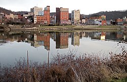
Buildings on Wheeling Island as viewed across the east channel of the Ohio River from downtown Wheeling in 2006. The hills in the background are in Belmont County, Ohio.
USA West Virginia location map.svg
Red pog.svg
Wheeling Island
Usa edcp location map.svg
Red pog.svg
Wheeling Island
Geography
Location Ohio River
Coordinates 40°04′14″N80°43′59″W / 40.07056°N 80.73306°W / 40.07056; -80.73306 Coordinates: 40°04′14″N80°43′59″W / 40.07056°N 80.73306°W / 40.07056; -80.73306
Administration
United States
West Virginia
Ohio County
Demographics
Population3,142 (2000)
Additional information
Time zone
  • Eastern

Wheeling Island is the most populated island in the Ohio River. [1] It lies within the city of Wheeling in Ohio County, West Virginia, in the United States. The 2000 census showed a resident population of 3,142 people on the island, which has a land area of 1.514 square kilometres (374 acres). [2] Neville Island, Pennsylvania, is larger (3.4 square kilometres (840 acres)) but has fewer people (1,232).

Contents

Wheeling Island lies at the mouths of Wheeling Creek of Ohio and Wheeling Creek of West Virginia. The island is home to the Wheeling Island Hotel-Casino-Racetrack at Wheeling Downs and Wheeling Island Stadium, home of the West Virginia State Football Championships.

Wheeling Island has a number of historic homes featuring Victorian Architecture. An elementary school (Madison Elementary, by Prominent WV Architect F.F. Faris, also Wheeling Island is the location of his personal residence), churches, a public pool (Bridge Park Pool), and several restaurants are located on the island.

A section of Wheeling Island is protected as part of the Ohio River Islands National Wildlife Refuge. [3]

Transportation

Wheeling Island is connected to downtown Wheeling via the Fort Henry Bridge, carrying Interstate 70, U.S. Route 40, and U.S. Route 250, and the Wheeling Suspension Bridge, carrying the National Road.

Two additional bridges cross the back channel of the Ohio River to connect the island to Bridgeport, one for Interstate 70, and a second for US 250 and US 40. The Aetnaville Bridge also crosses the back channel of the Ohio River, but was closed to vehicle traffic in 1988 and to the public in 2016 over safety concerns.

Variant names

Originally known by various names including Zanes Island and Madison Island, the Board on Geographic Names decided upon Wheeling Island as the bar's official name in 1902. Local residents refer to it as simply "The Island."

See also

Related Research Articles

<span class="mw-page-title-main">Ohio River</span> Major river in the midwestern United States

The Ohio River is a 981-mile (1,579 km) long river in the United States. It is located at the boundary of the Midwestern and Southern United States, flowing in a southwesterly direction from western Pennsylvania to its mouth on the Mississippi River at the southern tip of Illinois. It is the third largest river by discharge volume in the United States and the largest tributary by volume of the north-south flowing Mississippi River that divides the eastern from western United States. It is also the 6th oldest river on the North American continent. The river flows through or along the border of six states, and its drainage basin includes parts of 14 states. Through its largest tributary, the Tennessee River, the basin includes several states of the southeastern U.S. It is the source of drinking water for five million people.

<span class="mw-page-title-main">National Road</span> Early American improved highway

The National Road was the first major improved highway in the United States built by the federal government. Built between 1811 and 1837, the 620-mile (1,000 km) road connected the Potomac and Ohio Rivers and was a main transport path to the West for thousands of settlers. When improved in the 1830s, it became the second U.S. road surfaced with the macadam process pioneered by Scotsman John Loudon McAdam.

<span class="mw-page-title-main">Charleston, West Virginia</span> Capital city of West Virginia, U.S.

Charleston is the capital and most populous city of West Virginia. Located at the confluence of the Elk and Kanawha rivers, the city had a population of 48,864 at the 2020 census and an estimated population of 48,018 in 2021. The Charleston metropolitan area as a whole had an estimated 255,020 residents in 2021. Charleston is the center of government, commerce, and industry for Kanawha County, of which it is the county seat.

<span class="mw-page-title-main">Ohio County, West Virginia</span> County in West Virginia, United States

Ohio County is a county located in the Northern Panhandle of the U.S. state of West Virginia. As of the 2020 census, the population was 42,425. Its county seat is Wheeling. The county was formed in 1776 from the District of West Augusta, Virginia. It was named for the Ohio River, which forms its western boundary with the state of Ohio. West Liberty was designated as the county seat in 1777, serving to 1797.

<span class="mw-page-title-main">Mason County, West Virginia</span> County in West Virginia, United States

Mason County is a county in the U.S. state of West Virginia. As of the 2020 census, the population was 25,453. Its county seat and largest city is Point Pleasant. The county was founded in 1804 and named for George Mason, delegate to the U.S. Constitutional Convention. Before the Civil War, the county was in the State of Virginia.

<span class="mw-page-title-main">Marshall County, West Virginia</span> County in West Virginia, United States

Marshall County is a county in the U.S. state of West Virginia. At the 2020 census, the population was 30,591. Its county seat is Moundsville. With its southern border at what would be a continuation of the Mason-Dixon line to the Ohio River, it forms the base of the Northern Panhandle of West Virginia.

<span class="mw-page-title-main">Jackson County, West Virginia</span> County in West Virginia, United States

Jackson County is a county in the U.S. state of West Virginia. As of the 2020 census, the population was 27,791. Its county seat is Ripley, and its largest municipality is Ravenswood.

<span class="mw-page-title-main">Benwood, West Virginia</span> City in West Virginia

Benwood is a city in Marshall County, West Virginia, United States, along the Ohio River. It is part of the Wheeling, West Virginia Metropolitan Statistical Area. The population was 1,269 at the 2020 census.

<span class="mw-page-title-main">Wheeling, West Virginia</span> City in West Virginia, United States

Wheeling is a city in the U.S. state of West Virginia. Located almost entirely in Ohio County, of which it is the county seat, it lies along the Ohio River in the foothills of the Appalachian Mountains and also contains a tiny portion extending into Marshall County. Wheeling is located about 60 miles (96 km) west of Pittsburgh and is the principal city of the Wheeling metropolitan area. As of the 2020 census, the city had a population of 27,062, and the metro area had a population of 145,205.

<span class="mw-page-title-main">Southern Illinois</span> Region of Illinois in the United States

Southern Illinois, also known as Little Egypt, is the southern third of Illinois, principally along and south of Interstate 64. Although part of a Midwestern state, this region is aligned in culture more with that of the Upland South than the Midwest. Part of downstate Illinois, it is bordered by the two most voluminous rivers in the United States: the Mississippi below its connecting Missouri River to the west and the Ohio River to the east and south with the Wabash as tributary.

<span class="mw-page-title-main">U.S. Route 250</span> Highway in the United States

U.S. Route 250 is a route of the United States Numbered Highway System, and is a spur of U.S. Route 50. It currently runs for 514 miles (827 km) from Richmond, Virginia to Sandusky, Ohio. It passes through the states of Virginia, West Virginia, and Ohio. It goes through the cities of Richmond, Charlottesville, Staunton, and Waynesboro, Virginia; and Wheeling, West Virginia. West of Pruntytown, West Virginia, US 250 intersects and forms a short overlap with its parent US 50.

<span class="mw-page-title-main">Interstate 470 (Ohio–West Virginia)</span> Highway in Ohio and West Virginia

Interstate 470 (I-470) is a 10.63-mile-long (17.11 km) auxiliary Interstate Highway of I-70 that bypasses the city of Wheeling, West Virginia, in the US. I-470 is one of 13 auxiliary Interstate Highways in Ohio and the only auxiliary Interstate Highway in West Virginia. The western terminus of I-470 is an interchange with I-70 in Richland Township, Ohio. Traveling southeast through rural Belmont County, I-470 approaches the Vietnam Veterans Memorial Bridge, which spans the Ohio River. After crossing the river into Ohio County, West Virginia, the highway continues east toward the Wheeling communities of Bethlehem and Elm Grove and its eastern terminus at I-70 near Elm Grove. The portion of the highway in West Virginia is named the USS West Virginia Memorial Highway by proclamation of then-Governor Cecil H. Underwood on the 59th anniversary of the attack on Pearl Harbor.

<span class="mw-page-title-main">Bellaire Bridge</span> Bridge

The Bellaire Bridge or Interstate Bridge is a privately owned, closed cantilever truss toll bridge that spans the Ohio River between Benwood, West Virginia and Bellaire, Ohio. It provided a link for commuters between southern Ohio border towns and West Virginia steel mills from 1926 to 1991.

<span class="mw-page-title-main">Fort Henry Bridge</span> Bridge crossing the Ohio River

The Fort Henry Bridge is a crossing of the Ohio River main channel in Wheeling, West Virginia. The tied-arch bridge carries two lanes in each direction of Interstate 70 (I-70), U.S. Route 40 (US 40), and US 250. The bridge opened after four years of construction work on September 8, 1955, costing $6.8 million, $1.8 million over budget. The bridge, along with the aging Wheeling Suspension Bridge, are the only two road links from Wheeling Island to downtown Wheeling. In 2009, the structure carried an average of over 60,000 vehicles per day.

<span class="mw-page-title-main">U.S. Route 40 in West Virginia</span> Highway in West Virginia

In the U.S. state of West Virginia, U.S. Route 40 (US 40) runs for 16 miles (26 km) through the Northern Panhandle region. The highway enters the state on the Military Order of the Purple Heart bridge concurrent with US 250, crossing Wheeling Island, before joining Interstate 70 (I-70) over the Fort Henry Bridge before leaving the interstate. The highway travels north around Wheeling Hill, before traveling through the northeastern suburbs of Wheeling, Triadelphia and Valley Grove before entering Pennsylvania. A majority of the route still follows the old National Road which predates the U.S. Highway System.

<span class="mw-page-title-main">Ohio River Islands National Wildlife Refuge</span> Park in the United States of America

The Ohio River Islands National Wildlife Refuge (ORINWR) is a National Wildlife Refuge (NWR) in non-contiguous sites consisting of islands along 362 miles (583 km) of the Ohio River, primarily in the U.S. state of West Virginia. There are also two islands upstream in Beaver County, Pennsylvania, and a pair downstream in Lewis County, Kentucky. Going downstream, the refuge is currently located in parts of these counties: Beaver, Brooke, Ohio, Marshall, Wetzel, Tyler, Pleasants, Wood, Jackson, Mason, and Lewis. All counties are in West Virginia, with the exceptions in Pennsylvania and Kentucky mentioned above. The ORINWR was established in 1990 and consists of 3,354 acres (13.57 km2) of land and underwater habitat on 22 islands and four mainland properties. The refuge headquarters and visitor center is located in Williamstown, West Virginia.

<span class="mw-page-title-main">Interstate 70 in West Virginia</span> Highway in West Virginia

Interstate 70 (I-70) is a portion of the Interstate Highway System that runs from near Cove Fort, Utah, at a junction with I-15 to Baltimore, Maryland. It crosses the Northern Panhandle of West Virginia through Ohio County and the city of Wheeling. This segment is the shortest of all states through which I-70 passes, crossing West Virginia for only 14.45 miles (23.26 km). The Fort Henry Bridge carries I-70 from Wheeling Island across the Ohio River and into downtown Wheeling before the freeway enters the Wheeling Tunnel. I-470, a southerly bypass of Wheeling and the lone auxiliary Interstate Highway in West Virginia, is intersected near Elm Grove. Before crossing into Pennsylvania, I-70 passes The Highlands, a major shopping center in the panhandle, and the Bear Rocks Lake Wildlife Management Area. On average, between 27,000 and 53,000 vehicles use the freeway every day.

<span class="mw-page-title-main">U.S. Route 250 in West Virginia</span> Section of U.S. Highway in West Virginia

U.S. Route 250 (US 250) is a United States Numbered Highway that runs from Sandusky, Ohio, to Richmond, Virginia. Within the state of West Virginia, the route runs from the Ohio border in Wheeling to the Virginia border near Thornwood.

<span class="mw-page-title-main">Cherry Hill, Prince William County, Virginia</span> Census-designated place in Virginia, United States

Cherry Hill is a census-designated place (CDP) in Prince William County, Virginia, United States. The population was 16,000 according to the 2010 Census. As of the 2020 census, it was estimated to be 23,683. The CDP is made up of the Cherry Hill peninsula, to the northeast of the town of Dumfries.

<span class="mw-page-title-main">Wheeling Island Historic District</span> Historic district in West Virginia, United States

Wheeling Island Historic District is a national historic district located on Wheeling Island in Wheeling, Ohio County, West Virginia. The district includes 1,110 contributing buildings, 5 contributing sites, 2 contributing structures, and 3 contributing objects. It is a largely residential district consisting of two-story, frame detached dwellings built in the mid- to late-19th and early-20th century, including the Irwin-Brues House (1853) and a number of houses on Zane Street. The houses are representative of a number of popular architectural styles including Bungalow, Italianate, Queen Anne, and Colonial Revival. Notable non-residential contributing properties include the Exposition Building (1924), Thompson United Methodist Church (1913-1915), Madison School (1916), firehouse (1930-1931), the Bridgeport Bridge (1893), the Aetnaville Bridge (1891), "The Marina," Wheeling Island Baseball Park, and "Belle Island Park." It includes the separately listed Wheeling Suspension Bridge, Harry C. and Jessie F. Franzheim House, and John McLure House.

References

  1. Hay, Jerry M. (2008). Ohio River Guidebook. Inland Waterways Books. p. 22. Retrieved 22 November 2013.
  2. "U.S. Census Bureau: Census Tracts 5 and 6, Ohio County, West Virginia" . Retrieved 2020-03-29.
  3. "Ohio River Islands National Wildlife Refuge Brochure" (PDF). U.S. Fish & Wildlife Service - Ohio River Islands - About the Refuge. August 2013. Archived (PDF) from the original on April 15, 2021. Retrieved September 14, 2021.