Bridgeport, Ohio

Last updated

Bridgeport, Ohio
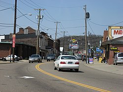
Downtown Bridgeport, Ohio.jpg
Downtown Bridgeport
Nickname: 
"Gateway to the West"
OHMap-doton-Bridgeport.png
Location of Bridgeport, Ohio
Map of Belmont County Ohio Highlighting Bridgeport Village.png
Location of Bridgeport in Belmont County
Coordinates: 40°4′20″N80°44′37″W / 40.07222°N 80.74361°W / 40.07222; -80.74361
CountryUnited States
State Ohio
County Belmont
Township Pease
Government
  TypeStatutory Village
  MayorNorma Teasdale
Area
[1]
  Total1.38 sq mi (3.56 km2)
  Land1.37 sq mi (3.54 km2)
  Water0.01 sq mi (0.03 km2)
Elevation
[2]
656 ft (200 m)
Population
 (2020)
  Total1,582
  Density1,158.13/sq mi (447.01/km2)
Time zone UTC-5 (Eastern (EST))
  Summer (DST) UTC-4 (EDT)
ZIP code
43912
Area code 740
FIPS code 39-08560 [3]
GNIS feature ID1064487 [2]

Bridgeport is a village in eastern Belmont County, Ohio, United States. It lies across the Ohio River from Wheeling, West Virginia, at the mouth of Wheeling Creek and is connected by two bridges to Wheeling Island. The population was 1,582 at the 2020 census. It is part of the Wheeling metropolitan area.

Contents

History

Bridgeport and Wheeling Island in 1904 Bridgeport and Island, Wheeling, W. Va (12660225843).jpg
Bridgeport and Wheeling Island in 1904

Bridgeport was originally known as Canton, and under the latter name was laid out in 1806 by Colonel Ebenezer Zane. [4] The present name is for a bridge constructed near the town site in the 1810s. [5]

Geography

Bridgeport is located along the Ohio River at the mouth of Wheeling Creek. [6] There are two crossings into West Virginia, the Military Order of the Purple Heart Bridge and a portion of the Fort Henry Bridge. Formerly, the Aetnaville Bridge and Bridgeport Bridge made the crossing to Wheeling Island, but the former has been closed to traffic and the latter has been demolished. [7] [8]

According to the United States Census Bureau, the village has a total area of 1.38 square miles (3.57 km2), of which 1.37 square miles (3.55 km2) is land and 0.01 square miles (0.03 km2) is water. [9]

Climate

Climate data for Bridgeport, Ohio
MonthJanFebMarAprMayJunJulAugSepOctNovDecYear
Record high °F (°C)73
(23)
78
(26)
84
(29)
90
(32)
92
(33)
98
(37)
103
(39)
98
(37)
95
(35)
88
(31)
81
(27)
73
(23)
103
(39)
Mean daily maximum °F (°C)38
(3)
42
(6)
51
(11)
63
(17)
73
(23)
82
(28)
85
(29)
84
(29)
77
(25)
66
(19)
54
(12)
42
(6)
63
(17)
Mean daily minimum °F (°C)21
(−6)
23
(−5)
31
(−1)
39
(4)
50
(10)
59
(15)
64
(18)
63
(17)
56
(13)
43
(6)
35
(2)
27
(−3)
43
(6)
Record low °F (°C)−16
(−27)
−3
(−19)
5
(−15)
20
(−7)
33
(1)
41
(5)
49
(9)
50
(10)
37
(3)
26
(−3)
15
(−9)
−10
(−23)
−16
(−27)
Average precipitation inches (mm)2.71
(69)
2.53
(64)
3.46
(88)
3.02
(77)
4.35
(110)
3.82
(97)
4.92
(125)
3.59
(91)
3.31
(84)
2.16
(55)
3.32
(84)
3.15
(80)
40.34
(1,024)
Average snowfall inches (cm)7.2
(18)
4.2
(11)
3.8
(9.7)
1.6
(4.1)
0
(0)
0
(0)
0
(0)
0
(0)
0
(0)
0.1
(0.25)
0.9
(2.3)
3.4
(8.6)
21.2
(53.95)
Source: [10]

Demographics

Historical population
CensusPop.Note
1830 169
1840 32994.7%
1860 641
1870 1,17883.8%
1880 2,395103.3%
1890 3,36940.7%
1900 3,96317.6%
1910 3,9740.3%
1920 3,9770.1%
1930 4,65517.0%
1940 4,8534.3%
1950 4,309−11.2%
1960 3,824−11.3%
1970 3,001−21.5%
1980 2,642−12.0%
1990 2,318−12.3%
2000 2,186−5.7%
2010 1,831−16.2%
2020 1,582−13.6%
U.S. Decennial Census [11]

2000 census

As of the census [3] of 2000, there were 2,186 people, 973 households, and 586 families living in the village. The population density was 1,569.0 inhabitants per square mile (605.8/km2). There were 1,090 housing units at an average density of 782.3 per square mile (302.0/km2). The racial makeup of the village was 90.81% White, 7.55% African American, 0.14% Native American, 0.14% Asian, 0.55% from other races, and 0.82% from two or more races. Hispanic or Latino of any race were 0.50% of the population.

There were 973 households, out of which 26.9% had children under the age of 18 living with them, 42.0% were married couples living together, 13.7% had a female householder with no husband present, and 39.7% were non-families. 36.1% of all households were made up of individuals, and 15.8% had someone living alone who was 65 years of age or older. The average household size was 2.24 and the average family size was 2.89.

In the village, the population was spread out, with 23.2% under the age of 18, 6.2% from 18 to 24, 29.0% from 25 to 44, 24.5% from 45 to 64, and 17.1% who were 65 years of age or older. The median age was 40 years. For every 100 females, there were 88.9 males. For every 100 females age 18 and over, there were 85.4 males.

The median income for a household in the village was $25,685, and the median income for a family was $33,231. Males had a median income of $24,156 versus $18,333 for females. The per capita income for the village was $14,723. About 11.5% of families and 16.2% of the population were below the poverty line, including 19.1% of those under age 18 and 7.3% of those age 65 or over.

2010 census

As of the census [12] of 2010, there were 1,831 people, 810 households, and 472 families living in the village. The population density was 1,336.5 inhabitants per square mile (516.0/km2). There were 943 housing units at an average density of 688.3 per square mile (265.8/km2). The racial makeup of the village was 89.7% White, 6.9% African American, 0.2% Asian, 0.2% from other races, and 3.0% from two or more races. Hispanic or Latino of any race were 0.2% of the population.

There were 810 households, of which 25.4% had children under the age of 18 living with them, 40.2% were married couples living together, 13.3% had a female householder with no husband present, 4.7% had a male householder with no wife present, and 41.7% were non-families. 35.6% of all households were made up of individuals, and 14.9% had someone living alone who was 65 years of age or older. The average household size was 2.26 and the average family size was 2.91.

The median age in the village was 43.3 years. 19.5% of residents were under the age of 18; 9% were between the ages of 18 and 24; 23.5% were from 25 to 44; 30.7% were from 45 to 64; and 17.4% were 65 years of age or older. The gender makeup of the village was 48.8% male and 51.2% female.
Education

Bridgeport has a public library, a branch of the Belmont County District Library. [13]

Notable people

Wheeling Creek near its mouth in Bridgeport in 2006 Wheeling Creek Ohio.jpg
Wheeling Creek near its mouth in Bridgeport in 2006

See also

Related Research Articles

<span class="mw-page-title-main">Barnesville, Ohio</span> Village in Ohio, United States

Barnesville is a village in Belmont County, Ohio, United States. It is located in the central portion of Warren Township in Belmont County and is part of the Wheeling metropolitan area. The population was 4,008 at the 2020 census.

<span class="mw-page-title-main">Belmont, Ohio</span> Village in Ohio, United States

Belmont is a village in central Belmont County, Ohio, United States. The population was 414 at the 2020 census. It is part of the Wheeling metropolitan area.

<span class="mw-page-title-main">Bethesda, Ohio</span> Village in Ohio, United States

Bethesda is a village in west-central Belmont County, Ohio, United States. The population was 1,211 at the 2020 census. It is part of the Wheeling metropolitan area.

<span class="mw-page-title-main">Brookside, Ohio</span> Village in Ohio, United States

Brookside is a village in eastern Belmont County, Ohio, United States. The population was 538 at the 2020 census. It is part of the Wheeling metropolitan area.

<span class="mw-page-title-main">Flushing, Ohio</span> Village in Ohio, United States

Flushing is a village in Belmont County, Ohio, United States. The population was 830 at the 2020 census.

<span class="mw-page-title-main">Holloway, Ohio</span> Village in Ohio, United States

Holloway is a village in Belmont County, Ohio, United States. The population was 330 at the 2020 census. It is part of the Wheeling metropolitan area. Holloway was laid out in 1883, and named after the local Holloway family.

<span class="mw-page-title-main">Martins Ferry, Ohio</span> City in Ohio, United States

Martins Ferry is the most populous city in Belmont County, Ohio, United States. The population was 6,260 as of the 2020 census. Located along the Ohio River across from Wheeling, West Virginia, it is part of the Wheeling metropolitan area.

<span class="mw-page-title-main">Morristown, Ohio</span> Village in Ohio, United States

Morristown is a village in Belmont County, Ohio, United States. The population was 248 at the 2020 census. It is part of the Wheeling metropolitan area.

<span class="mw-page-title-main">Neffs, Ohio</span> Census-designated place in Ohio, United States

Neffs is an unincorporated community and census-designated place in northwestern Pultney Township, Belmont County, Ohio, United States. The population was 878 at the 2020 census. It is part of the Wheeling metropolitan area.

<span class="mw-page-title-main">Powhatan Point, Ohio</span> Village in Ohio, United States

Powhatan Point is a village in southeastern Belmont County, Ohio, United States, along the Ohio River. The population was 1,461 at the 2020 census. It is part of the Wheeling metropolitan area.

<span class="mw-page-title-main">Shadyside, Ohio</span> Village in Ohio, United States

Shadyside is a village in eastern Belmont County, Ohio, United States, along the Ohio River. The population was 3,454 at the 2020 census. It is part of the Wheeling metropolitan area.

<span class="mw-page-title-main">St. Clairsville, Ohio</span> City in Ohio, United States

St. Clairsville or Saint Clairsville is a city in and the county seat of Belmont County, Ohio, United States. The population was 5,096 at the 2020 census. It is part of the Wheeling metropolitan area.

<span class="mw-page-title-main">Aberdeen, Ohio</span> Village in Ohio, United States

Aberdeen is a village in Huntington Township, Brown County, Ohio, United States, along the Ohio River 50 miles (80 km) southeast of Cincinnati. The population was 1,515 at the 2020 census.

<span class="mw-page-title-main">Gann, Ohio</span> Village in Ohio, United States

Brinkhaven, once known as Mount Holly and Gann, is a village in Knox County, Ohio, United States. The population was 114 at the 2020 census.

<span class="mw-page-title-main">Brewster, Ohio</span> Village in Ohio, United States

Brewster is a village in southwestern Stark County, Ohio, United States. The population was 2,113 at the 2020 census. It is part of the Canton–Massillon metropolitan area.

<span class="mw-page-title-main">Windsor Heights, West Virginia</span> Village in West Virginia, United States

Windsor Heights is a village in Brooke County, West Virginia, United States. It is part of the Wheeling, West Virginia Metropolitan Statistical Area. The population was 423 at the 2010 census. Grace Davis was the mayor as of June, 2017.

<span class="mw-page-title-main">Clearview, West Virginia</span> Village in West Virginia, United States

Clearview is a village in Ohio County, West Virginia, United States. It is part of the Wheeling, West Virginia Metropolitan Statistical Area. The population was 565 at the 2010 census.

<span class="mw-page-title-main">Fairview, Ohio</span> Village in Ohio, United States

Fairview is a village in Belmont and Guernsey counties in the U.S. state of Ohio. The population was 67 as of the 2020 census. It is part of the Wheeling metropolitan area.

<span class="mw-page-title-main">Wilson, Ohio</span> Village in Ohio, United States

Wilson is a village in Belmont and Monroe counties in the U.S. state of Ohio. The population was 129 at the 2020 census. It is part of the Wheeling metropolitan area.

<span class="mw-page-title-main">Yorkville, Ohio</span> Village in Ohio, United States

Yorkville is a village in Belmont and Jefferson counties in the U.S. state of Ohio. The population was 968 at the 2020 census. Yorkville lies within two Metropolitan Statistical Areas; the Belmont County portion is part of the Wheeling metropolitan area, while the Jefferson County portion is part of the Weirton–Steubenville metropolitan area.

References

  1. "ArcGIS REST Services Directory". United States Census Bureau. Retrieved September 20, 2022.
  2. 1 2 "US Board on Geographic Names". United States Geological Survey. October 25, 2007. Retrieved January 31, 2008.
  3. 1 2 "U.S. Census website". United States Census Bureau . Retrieved January 31, 2008.
  4. McKelvey, A. T. (1903). Centennial History of Belmont County, Ohio, and Representative Citizens. Biographical Publishing Company. pp.  203–204.
  5. Overman, William Daniel (1958). Ohio Town Names. Akron, OH: Atlantic Press. p. 18.
  6. Ohio Atlas & Gazetteer. Yarmouth, Me.: DeLorme. 1991. pp. 62–63. ISBN   0-89933-233-1.
  7. "Group Fighting to Save Aetnaville Bridge from Demolition". November 12, 2014.
  8. Betty J. Pokas (September 12, 2011). "Long-Standing Bridgeport Bridge Razed Today". Wheeling News-Register. Archived from the original on December 9, 2011. Retrieved September 14, 2011.
  9. "US Gazetteer files 2010". United States Census Bureau. Archived from the original on January 25, 2012. Retrieved January 6, 2013.
  10. "Intellicast | Weather Underground".
  11. "Census of Population and Housing". Census.gov. Retrieved June 4, 2015.
  12. "U.S. Census website". United States Census Bureau . Retrieved January 6, 2013.
  13. "Locations & Hours". Belmont County District Library. Retrieved February 25, 2018.