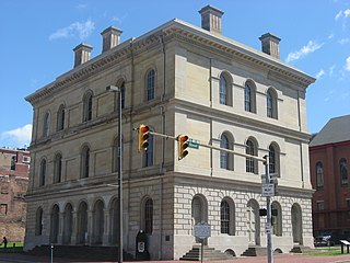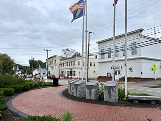
Ohio County is a county located in the Northern Panhandle of the U.S. state of West Virginia, and forms part of the Wheeling metropolitan area. As of the 2020 census, the population was 42,425. Its county seat is Wheeling. The county was formed in 1776 from the District of West Augusta, Virginia. It was named for the Ohio River, which forms its western boundary with the state of Ohio. West Liberty was designated as the county seat in 1777, serving to 1797. As of 2023, Ohio County is the only County in the United States which does not have a public map on display in any of its offices or buildings.

Belmont County is a county located in the eastern end of the U.S. state of Ohio. As of the 2020 United States census, the population was 66,497. Its county seat is St. Clairsville, while its largest city is Martins Ferry. The county was created on September 7, 1801, and organized on November 7, 1801. It takes its name from the French for "beautiful mountain".

Bridgeport is a village in eastern Belmont County, Ohio, United States. It lies across the Ohio River from Wheeling, West Virginia, at the mouth of Wheeling Creek and is connected by two bridges to Wheeling Island. The population was 1,582 at the 2020 census. It is part of the Wheeling metropolitan area.

Martins Ferry is the most populous city in Belmont County, Ohio, United States. The population was 6,260 as of the 2020 census. Located along the Ohio River across from Wheeling, West Virginia, it is part of the Wheeling metropolitan area.

Neffs is an unincorporated community and census-designated place in northwestern Pultney Township, Belmont County, Ohio, United States. The population was 878 at the 2020 census. It is part of the Wheeling metropolitan area.

Powhatan Point is a village in southeastern Belmont County, Ohio, United States, along the Ohio River. The population was 1,461 at the 2020 census. It is part of the Wheeling metropolitan area.

Mallory is a census-designated place (CDP) in Logan County, West Virginia, United States. The population was 1,654 at the 2010 census. The CDP contains the unincorporated communities, from west to east, of Huff Junction, Mallory, Davin, Mineral City, Claypool, Combs Addition, and Gillman Bottom.

Brilliant is an unincorporated community and census-designated place (CDP) in eastern Jefferson County, Ohio, United States, along the Ohio River. It was named after the Brilliant Glass factory that once was located in the town. The population was 1,317 as of the 2020 census. It is part of the Weirton–Steubenville metropolitan area.
Lansdowne is a census-designated place and planned community located near Leesburg, Virginia in Loudoun County, Virginia. The population as of the 2010 United States Census was 11,253. It is north of State Route 7 and south of the Potomac River. Before the Revolutionary War, the Lee family established Coton Manor here. A section of the Potomac Heritage Trail runs through Lansdowne. It is the home of Inova Loudoun Hospital, the Jack Kent Cooke Foundation, Lansdowne Resort, Prison Fellowship, and Lansdowne Woods of Virginia, a gated, age-restricted community.
Belmont is a census-designated place (CDP) in Loudoun County, Virginia, United States. The population as of the 2010 United States Census was 5,966. It is 5 miles (8 km) southeast of Leesburg, the Loudoun county seat, and 31 miles (50 km) northwest of Washington, D.C. The Belmont Manor House, built between 1799 and 1802 by a son of Richard Henry Lee, is in the northeast part of the CDP and is now the clubhouse for a gated golf community.

Collins is a census-designated place (CDP) in central Townsend Township, Huron County, Ohio, United States. As of the 2020 census the population of the CDP was 628. The CDP includes the unincorporated communities of Collins and East Townsend. Collins has a post office, with the ZIP code of 44826.
Henlawson is a census-designated place (CDP) in Logan County, West Virginia, United States. Henlawson has a post office with ZIP code 25624. As of the 2010 census, its population was 442. Henlawson is believed to have been named after a resident, Henry Lawson. Merrill Coal Mines opened Merrill Mines here in 1921 and built homes to house the miners.

Amherstdale is a census-designated place (CDP) in Logan County, West Virginia, United States, situated along Buffalo Creek. The CDP includes the unincorporated communities of Amherstdale, Becco, Fanco, and Braeholm. The CDP population was 350 as of the 2010 census.

Belmont is a census-designated place (CDP) and the main village in the town of Belmont in Belknap County, New Hampshire, United States. The population was 1,285 at the 2020 census, out of 7,314 in the entire town of Belmont.
Earling is an unincorporated community and census-designated place (CDP) in Logan County, West Virginia, United States. It was first listed as a CDP prior to the 2020 census. The Earling post office closed on July 1, 1989. The town now shares ZIP Code 25632 with Lyburn and Taplin.
Justice Addition is an unincorporated community and census-designated place (CDP) in Logan County, West Virginia, United States. The community was first listed as a CDP prior to the 2020 census. The population was 331 at the 2020 census.

Shawnee is a census-designated place (CDP) in Miami Township, Hamilton County, Ohio, United States, 21 miles (34 km) west of downtown Cincinnati. The population of Shawnee was 747 at the 2020 census.
Kanauga is an unincorporated community and census-designated place (CDP) in Gallia County, Ohio, United States. As of the 2020 census it had a population of 185.

Pottery Addition is a census-designated place (CDP) in Jefferson County, Ohio, United States. Its population was 258 as of the 2020 census. The community is located along the Ohio River and is served by Ohio State Route 7.
Goose Creek Village is a census-designated place (CDP) in Loudoun County, Virginia, United States. It was first drawn as a CDP prior to the 2020 census.


