Dry Fork (Tug Fork tributary)

Last updated
Dry Fork

Dry Fork stream in McDowell County, West Virginia.jpg

Flowing through McDowell County
Country United States
Physical characteristics
Main source Stony Ridge near Adria, Tazewell County, Virginia
River mouth Tug Fork at Iaeger, McDowell County, West Virginia

The Dry Fork is a 47.7-mile-long (76.8 km) [1] tributary of the Tug Fork, belonging to the Ohio River watershed. The river is located in McDowell County, West Virginia, and Tazewell County, Virginia, in the United States. The mouth of the Dry Fork into the Tug Fork is located at Iaeger.

Tributary stream or river that flows into a main stem river or lake

A tributary or affluent is a stream or river that flows into a larger stream or main stem river or a lake. A tributary does not flow directly into a sea or ocean. Tributaries and the main stem river drain the surrounding drainage basin of its surface water and groundwater, leading the water out into an ocean.

Tug Fork river in the United States of America

The Tug Fork is a tributary of the Big Sandy River, 159 miles (256 km) long, in southwestern West Virginia, southwestern Virginia, and eastern Kentucky in the United States. Via the Big Sandy and Ohio rivers, it is part of the watershed of the Mississippi River.

Ohio River river in the midwestern United States

The Ohio River is a 981-mile (1,579 km) long river in the midwestern United States that flows southwesterly from western Pennsylvania south of Lake Erie to its mouth on the Mississippi River at the southern tip of Illinois. It is the second largest river by discharge volume in the United States and the largest tributary by volume of the north-south flowing Mississippi River that divides the eastern from western United States. The river flows through or along the border of six states, and its drainage basin includes parts of 15 states. Through its largest tributary, the Tennessee River, the basin includes several states of the southeastern U.S. It is the source of drinking water for three million people.

Contents

Variant names

According to the United States Geological Survey's Geographic Names Information System, the Dry Fork has been known by the following names throughout its history:

United States Geological Survey scientific agency of the United States government

The United States Geological Survey is a scientific agency of the United States government. The scientists of the USGS study the landscape of the United States, its natural resources, and the natural hazards that threaten it. The organization has four major science disciplines, concerning biology, geography, geology, and hydrology. The USGS is a fact-finding research organization with no regulatory responsibility.

Geographic Names Information System geographical database

The Geographic Names Information System (GNIS) is a database that contains name and locative information about more than two million physical and cultural features located throughout the United States of America and its territories. It is a type of gazetteer. GNIS was developed by the United States Geological Survey in cooperation with the United States Board on Geographic Names (BGN) to promote the standardization of feature names.

Tributaries

Tributary streams are listed from source to mouth.

Vall Creek is a stream in the U.S. state of West Virginia.

War Creek is a stream in the U.S. state of West Virginia.

List of cities and towns along the Dry Fork

Apple Grove, McDowell County, West Virginia Unincorporated community in West Virginia, United States

Apple Grove is an unincorporated community located in McDowell County, West Virginia, United States. Apple Grove is located along West Virginia Route 80 on the Dry Fork south of Iaeger.

Atwell, West Virginia Unincorporated community in West Virginia, United States

Atwell is an unincorporated community located in McDowell County, West Virginia, United States. Atwell lies along the Norfolk and Western Railroad on the Dry Fork.

Avondale, McDowell County, West Virginia Unincorporated community in West Virginia, United States

Avondale is an unincorporated community located in McDowell County, West Virginia, United States. Avondale lies along the Norfolk and Western Railroad on the Dry Fork. According to the Geographic Names Information System, the community has also been known as Ritter having been named after William McLellan Ritter, founder of the W.M. Ritter company.

See also

Related Research Articles

Shenandoah River river in Virginia and West Virginia, United States

The Shenandoah River is a tributary of the Potomac River, 55.6 miles (89.5 km) long with two forks approximately 100 miles (160 km) long each, in the U.S. states of Virginia and West Virginia. The principal tributary of the Potomac, the river and its tributaries drain the central and lower Shenandoah Valley and the Page Valley in the Appalachians on the west side of the Blue Ridge Mountains, in northwestern Virginia and the Eastern Panhandle of West Virginia.

Black Fork (Cheat River tributary) river in the United States of America

The Black Fork is a principal tributary of the Cheat River in the Allegheny Mountains of eastern West Virginia, USA. It is a short stream, about four miles (6 km) in length, formed by the confluence of two other streams not far above its mouth. It was traditionally considered one of the five Forks of Cheat.

Dry Fork (Cheat River tributary) tributary of the Black Fork of the Cheat River in West Virginia, USA

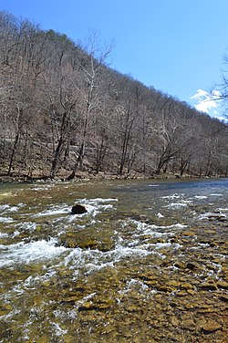
The Dry Fork is a 39.1-mile-long (62.9 km) tributary of the Black Fork of the Cheat River in the Allegheny Mountains of eastern West Virginia, USA. Via the Black Fork, the Cheat, and the Monongahela and Ohio rivers, it is part of the watershed of the Mississippi River. The Dry Fork flows for much of its length in the Monongahela National Forest and drains mostly rural and forested areas. It was traditionally considered one of the five Forks of Cheat.

Sleepy Creek river in the United States of America

Sleepy Creek is a 44.0-mile-long (70.8 km) tributary of the Potomac River in the United States, belonging to the Chesapeake Bay's watershed. The stream rises in Frederick County, Virginia, and flows through Morgan County, West Virginia before joining the Potomac near the community of Sleepy Creek.

Goose Creek (Potomac River tributary) tributary of the Potomac River in Virginia, United States

Goose Creek is a 53.9-mile-long (86.7 km) tributary of the Potomac River in Fauquier and Loudoun counties in northern Virginia. It comprises the principal drainage system for the Loudoun Valley.

Seneca Creek (North Fork South Branch Potomac River) river in the United States of America

Seneca Creek is a 19.6-mile-long (31.5 km) tributary of the North Fork of the South Branch of the Potomac River located entirely within Pendleton County, West Virginia, USA.

Roubidoux Creek is a tributary to the Gasconade River in the Ozarks of south central Missouri named after French explorer Joseph Robidoux. It is 57.4 miles (92.4 km) long. Due to its colder water temperatures, it is listed as a trout stream. Roubidoux Spring is a landmark that is nestled just south of downtown Waynesville. The creek cuts north through Fort Leonard Wood before crossing underneath Interstate 44 and into the city limits of Waynesville.

Elkhorn Creek is a 23.7-mile-long (38.1 km) tributary of the Tug Fork, belonging to the Ohio River and Mississippi River watersheds. It is located in McDowell and Mercer counties in the U.S. state of West Virginia. Elkhorn Creek is also known as Elkhorn Fork and Elkhorn River.

Fourpole Creek is a 4.8-mile-long (7.7 km) tributary of the Tug Fork, belonging to the Ohio River and Mississippi River watersheds. It is located in McDowell and Mingo counties in the U.S. state of West Virginia. Fourpole Creek forms the boundary between McDowell and Mingo counties.

Glady Fork river in the United States of America

Glady Fork is a 31.9-mile-long (51.3 km) river in the Allegheny Mountains of eastern West Virginia, USA. It is considered one of the five principal headwaters tributaries of the Cheat River — known as the Forks of Cheat.

Laurel Fork (Cheat River tributary) river in the United States of America

Laurel Fork is a 37.8-mile-long (60.8 km) river in eastern West Virginia, USA. It is a tributary of the Dry Fork; via the Dry Fork, the Black Fork, and the Cheat, Monongahela and Ohio rivers, it is part of the watershed of the Mississippi River, draining an area of 60 square miles (160 km2) in the Allegheny Mountains. With the Dry Fork, the Glady Fork, the Shavers Fork and the Blackwater River, it is considered to be one of the five principal headwaters tributaries of the Cheat River.

Panther, West Virginia Unincorporated community in West Virginia, United States

Panther is an unincorporated community in McDowell County, West Virginia, United States. Panther is located along the Tug Fork 4.5 miles (7.2 km) west-northwest of Iaeger. Panther has a post office with ZIP code 24872.

Litwar, West Virginia Unincorporated community in West Virginia, United States

Litwar is an unincorporated community in McDowell County, West Virginia, United States. Litwar is located on the Tug Fork 2 miles (3.2 km) west-northwest of Iaeger.

Garland, West Virginia Unincorporated community in West Virginia, United States

Garland is an unincorporated community in McDowell County, West Virginia, United States. Garland is located near West Virginia Route 80 3.5 miles (5.6 km) north-northeast of Bradshaw.

Krollitz, West Virginia Unincorporated community in West Virginia, United States

Krollitz is an unincorporated community in McDowell County, West Virginia, United States. Krollitz is 2.8 miles (4.5 km) west of Iaeger.

Laurel Fork (North Fork South Branch Potomac River tributary)

The Laurel Fork is a 15.7-mile-long (25.3 km) stream in Virginia and West Virginia, United States. The stream flows north from Highland County, Virginia, where its source and the majority of its length is located, to its mouth in Pendleton County, West Virginia. Laurel Fork is a tributary to the North Fork South Branch Potomac River, making it a part of the Potomac River watershed. The area surrounding Laurel Fork is home to several plant and animal species found nowhere else in Virginia, and is a prime example of a northern boreal forest in the state.

Alum Creek is a stream in the U.S. state of West Virginia. It is a tributary of Tug Fork.

Panther Creek is a stream in the U.S. state of West Virginia. It is a tributary of the Tug Fork.

References

  1. U.S. Geological Survey. National Hydrography Dataset high-resolution flowline data. The National Map Archived 2012-04-05 at WebCite , accessed June 13, 2011