Crany, West Virginia

Last updated

Crany
Post Office - Crany, West Virginia.jpg
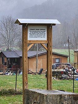
In the mid-1850s, there was a sufficient population at Crany for the establishment of a post office, the second one in Wyoming County. The first post office was at Oceana, the county seat.
Farm House - Crany, West Virginia.jpg
A farm house in Crany, West Virginia.
USA West Virginia location map.svg
Red pog.svg
Crany
Location within the state of West Virginia
Usa edcp location map.svg
Red pog.svg
Crany
Crany (the United States)
Coordinates: 37°44′24″N81°32′09″W / 37.74000°N 81.53583°W / 37.74000; -81.53583
Country United States
State West Virginia
County Wyoming
Elevation
1,506 ft (459 m)
Time zone UTC-5 (Eastern (EST))
  Summer (DST) UTC-4 (EDT)
ZIP codes
24870
GNIS ID 1549645 [1]

Crany is an unincorporated community in Wyoming County, West Virginia, United States, situated along the Clear Fork. [2] It was one of the originally populated settlements of the region and is situated in a fertile farming plain. The community consists of small family farms, has retained much of the descendants of the original pioneers of the region, and was a historically important region for logging in the early 20th century. [3]

Contents

Etymology

The origin of the name has been explained through two traditional stories stating that the community was named after the Crane Fork, a small tributary of the Clear Fork, which was later shortened to Crany deriving from the mountain dialect spoken by the pioneer settlers. Another explanation of the etymology may stem from a misprint of the word Cranny, meaning an obscure nook or corner. [4]

History

A sign stating the burial location of revolutionary war hero Ralph Stewart. Grave of Ralph Stewart - Crany, West Virginia.jpg
A sign stating the burial location of revolutionary war hero Ralph Stewart.

In 1795, the Valley that surrounds Crany was surveyed as part of Montgomery County, Virginia as a larger tract of land belonging to Joseph Tidball and Charles Myn Thurston. James Welch acquired the land patent and sold it to Joseph Mandeville in 1797. [5] Captain Ralph Stewart and his family were the first settlers of Crany arriving in 1800, although he did not legally own land in the county, Stewart settled in the Crany Fork Valley, where his children also settled and married into local families. [6]

Stewart was the second settler in the area within the modern-day county, along with John Cooke who settled and founded Oceana. Stewart first squatted on the land to escape being arrested for murders he committed, despite being later pardoned by the governor, he chose to live in the wilderness surrounded by mountains of the region that rise over 2,000 feet. Stewart's headstone stands at the mouth of Bee Branch in Crany. [7]

Ralph Canterbury, Daniel Gunnoe, and Perry Bailey were among the businessmen who operated several stores at different Crany locations in the 19th century. The Crany community had a school built in 1850, authorized by the county board of education led by William Brooks. Richard Brooks, William's father, was the first teacher. Two schools, Crany and Adkin, were established and served the children of the valley. The Crany school was abolished between the 1940s and '50s, while the Adkin school was abolished around 1965. The Crany Missionary Baptist Church was founded by Rev. James L. Marshall in 1886 and initially held services in the school and in homes. The congregation now meets in a modern building located midway through the valley. [8]

Related Research Articles

<span class="mw-page-title-main">Wyoming County, West Virginia</span> County in West Virginia, United States

Wyoming County is a county in the U.S. state of West Virginia. As of the 2020 census, the population was 21,382. Its county seat is Pineville. The county was created in 1850 from Logan County and named for the Lenape word meaning "large plains".

<span class="mw-page-title-main">Woodstock, Virginia</span> Town in Virginia, United States

Woodstock is a town and the county seat of Shenandoah County, Virginia, United States. It has a population of 5,212 according to the 2017 census. Woodstock comprises 3.2 square miles of incorporated area of the town, and is located along the "Seven Bends" of the north fork of the Shenandoah River. While some tourism references list Woodstock as the fourth oldest town in Virginia, the area was sparsely settled and perhaps platted in 1752 or shortly thereafter, but the town was actually established by charter in 1761. While there are a number of Virginia towns closer to the eastern seaboard that claim earlier founding dates, Woodstock was one of the first towns west of the Blue Ridge.

<span class="mw-page-title-main">Abingdon, Virginia</span> Town in Virginia, United States

Abingdon is a town in Washington County, Virginia, United States, 133 miles (214 km) southwest of Roanoke. The population was 8,376 at the 2020 census. It is the county seat of Washington County. The town encompasses several historically significant sites and features a fine arts and crafts scene centered on the galleries and museums along Main Street.

<span class="mw-page-title-main">Harts, West Virginia</span> Census-designated place in West Virginia, United States

Harts is a census-designated place (CDP) at the mouth of Big Harts Creek in Lincoln County, West Virginia, United States, situated along the Guyandotte River. As of the 2010 census, its population was 656. Harts is a part of the Huntington-Ashland, WV-KY-OH, Metropolitan Statistical Area (MSA). The Harts CDP includes the unincorporated communities of Harts, Atenville, Ferrellsburg, and Sand Creek.

<span class="mw-page-title-main">Shenandoah Valley</span> Region of Virginia and West Virginia

The Shenandoah Valley is a geographic valley and cultural region of western Virginia and the Eastern Panhandle of West Virginia in the United States. The valley is bounded to the east by the Blue Ridge Mountains, to the west by the eastern front of the Ridge-and-Valley Appalachians, to the north by the Potomac River and to the south by the James River. The cultural region covers a larger area that includes all of the valley plus the Virginia highlands to the west, and the Roanoke Valley to the south. It is physiographically located within the Ridge and Valley province and is a portion of the Great Appalachian Valley.

<span class="mw-page-title-main">Tug Fork</span> River in the Eastern United States

The Tug Fork is a tributary of the Big Sandy River, 159 miles (256 km) long, in southwestern West Virginia, southwestern Virginia, and eastern Kentucky in the United States. Via the Big Sandy and Ohio rivers, it is part of the watershed of the Mississippi River.

<span class="mw-page-title-main">South Branch Potomac River</span> River in United States

The South Branch Potomac River has its headwaters in northwestern Highland County, Virginia near Hightown along the eastern edge of the Allegheny Front. After a river distance of 139 miles (224 km), the mouth of the South Branch lies east of Green Spring in Hampshire County, West Virginia where it meets the North Branch Potomac River to form the Potomac.

<span class="mw-page-title-main">Tygart Valley River</span> River in West Virginia, United States

The Tygart Valley River — also known as the Tygart River — is a principal tributary of the Monongahela River, approximately 135 miles (217 km) long, in east-central West Virginia in the United States. Via the Monongahela and Ohio rivers, it is part of the watershed of the Mississippi River, draining an area of 1,329 square miles (3,440 km2) in the Allegheny Mountains and the unglaciated portion of the Allegheny Plateau.

French Creek is an unincorporated community in Upshur County, West Virginia, United States.

<span class="mw-page-title-main">Great Indian Warpath</span> Part of network of trails in eastern North America used by Native Americans

The Great Indian Warpath (GIW)—also known as the Great Indian War and Trading Path, or the Seneca Trail—was that part of the network of trails in eastern North America developed and used by Native Americans which ran through the Great Appalachian Valley. The system of footpaths extended from what is now upper New York to deep within Alabama. Various Native peoples traded and made war along the trails, including the Catawba, numerous Algonquian tribes, the Cherokee, and the Iroquois Confederacy. The British traders' name for the route was derived from combining its name among the northeastern Algonquian tribes, Mishimayagat or "Great Trail", with that of the Shawnee and Delaware, Athawominee or "Path where they go armed".

The Staunton–Parkersburg Turnpike was built in what is now the U.S. states of Virginia and West Virginia during the second quarter of the 19th century to provide a roadway from Staunton, Virginia and the upper Shenandoah Valley to the Ohio River at present-day Parkersburg, West Virginia. Engineered by Claudius Crozet through the mountainous terrain, it was a toll road partially funded by the Virginia Board of Public Works. Control of this road became crucial during the American Civil War. Today, the Staunton-Parkersburg Turnpike can be largely traversed by following West Virginia Route 47 east from Parkersburg to Linn, then U.S. Route 33 east through Weston and Buckhannon to Elkins, then U.S. Route 250 southeast through Beverly, Huttonsville, crossing the West Virginia/Virginia state line to Staunton, Virginia.

<span class="mw-page-title-main">Germany Valley</span>

Germany Valley is a scenic upland valley high in the Allegheny Mountains of eastern West Virginia originally settled by German farmers in the mid-18th century. It is today a part of the Spruce Knob–Seneca Rocks National Recreation Area of the Monongahela National Forest, although much ownership of the Valley remains in private hands.

<span class="mw-page-title-main">Shavers Mountain</span>

Shavers Mountain, is a high and rugged ridge situated in the Allegheny Mountains of eastern West Virginia. It is about 35 miles (56 km) long, north to south, and several of its peaks exceed 4,000 feet (1,200 m) in elevation. Shavers Mountain is notable for being "bookended", at its northern and southern ends, by two exceptional natural areas: the Otter Creek Wilderness and the Gaudineer Scenic Area, respectively, both of which preserve small stands of old growth forest on the mountain.

<span class="mw-page-title-main">Orlando, West Virginia</span> Human settlement in West Virginia, United States of America

Orlando is an unincorporated community located in Braxton and Lewis counties, West Virginia, United States. It is located on Oil Creek, a tributary of the Little Kanawha River.

Freedom is an unincorporated community in both northeastern Caribou County, Idaho, and northwestern Lincoln County, Wyoming, in the United States; the Wyoming portion of the community is also a census-designated place (CDP). The population was 247 at the 2020 census.

Clayton is an unincorporated community in Summers County, West Virginia, United States. The community was first settled in 1813. Clayton once had a post office, which opened in 1879 and closed in 1959.

<span class="mw-page-title-main">Shively, West Virginia</span> Unincorporated community in West Virginia, United States

Shively is an unincorporated community located on the Smokehouse Fork of Big Harts Creek in Logan County, West Virginia, United States. Shively is accessed by County Route 3. It is situated 7.2 miles from Harts and 9.3 miles from Chapmanville.

<span class="mw-page-title-main">Clear Fork (Guyandotte River tributary)</span> River in the United States of America

The Clear Fork is a tributary of the Guyandotte River, 29 miles (47 km) long, in southern West Virginia in the United States. Via the Guyandotte and Ohio rivers, it is part of the watershed of the Mississippi River, draining an area of 129 square miles (330 km2) in a rural area on the unglaciated portion of the Allegheny Plateau. The Clear Fork flows for its entire length in Wyoming County; its tributary the Laurel Fork also drains a small area of western Raleigh County.

<span class="mw-page-title-main">Lincoln County feud</span>

The Lincoln County feud occurred in the Harts Creek community of Lincoln and Logan counties, West Virginia, between 1878 and 1890.

Lovelton is an unincorporated populated place in North Branch Township, Wyoming County, Pennsylvania, United States. It is in the United States Geological Survey quadrangle of Jenningsville.

References

  1. U.S. Geological Survey Geographic Names Information System: Crany, West Virginia
  2. West Virginia Atlas & Gazetteer. Yarmouth, Me.: DeLorme. 1997. p. 58. ISBN   0-89933-246-3.
  3. Blankenship, Paul Ray (1999). From Cabins To Coal Mines, 1799-1999, Volume I. (1st ed.).
  4. "Definition of CRANNY". www.merriam-webster.com. Retrieved March 23, 2023.
  5. "History of southwest Virginia, 1746-1786, Washington County, 1777-1870 :: :: University of Virginia Library". xtf.lib.virginia.edu. Retrieved March 23, 2023.
  6. "Capt. Ralph Stewart Historical Marker". www.hmdb.org. Retrieved March 23, 2023.
  7. Sibray, David (March 16, 2022). "West Virginia mountains provided refuge for Indian fighter - West Virginia Explorer". wvexplorer.com. Retrieved March 23, 2023.
  8. "Crany community rich in history". Wyoming County Report. Retrieved March 23, 2023.