West Virginia United is an American soccer team based in Charleston, West Virginia. Founded in 2003, the team plays in USL League Two, the fourth tier of the American Soccer Pyramid.
The West Virginia State Highway System is an integrated system of numbered roads in the U.S. state of West Virginia. These highways were coordinated by the West Virginia Department of Transportation, Division of Highways.
Stony Bottom is an unincorporated community located in Pocahontas County, West Virginia, United States. In the early 19th century, the town was known as Seldom Seen. At some point, this was changed to Driftwood by loggers who would drift logs by on the Greenbrier River. By 1908, it took its present name because of all the stones and rocks present in the area. The town currently has seasonal residents, as well as full-time residents and a small church named Alexander Memorial Presbyterian Church. On Labor Day of every year, the small town accommodated hundreds of people for the annual Hunter Reunion, where local resident Homer Hunter invited the community to take part in traditional bluegrass music, food, and fellowship. The town is nestled between the Greenbrier River and the Greenbrier River Trail, suitable for biking, horseback riding, and more. Their Post Office has been closed.
Bottom Creek is an unincorporated community located in McDowell County, West Virginia, United States. Bottom Creek lies along U.S. Route 52 between the towns of Kimball and Vivian. It takes its name from the stream that runs through the community.
The Huntington–Ashland metropolitan area is a metropolitan area in the Appalachian Plateau region of the United States. Referred to locally as the "Tri-State area," and colloquially as "Kyova", the region spans seven counties in the three states of Kentucky, Ohio, and West Virginia. With a population of 361,580, the Tri-State area is nestled along the banks of the Ohio River. The region offers a diverse range of outdoor activities.

The Weirton–Steubenville, WV–OH Metropolitan Statistical Area, also known as the Upper Ohio Valley, is a metropolitan statistical area consisting of two counties in the Northern Panhandle of West Virginia and one in Ohio, anchored by the cities of Weirton and Steubenville. As of the 2020 census, the MSA had a population of 116,903. This puts it at 334th largest in the United States. It is also included in the larger Pittsburgh–New Castle–Weirton, PA–OH–WV Combined Statistical Area.
Sharon is an unincorporated community and coal town in southeastern Kanawha County, West Virginia, United States, located along the West Virginia Turnpike.

Green Bottom Wildlife Management Area is located on former plantation lands of U.S. Congressman and Confederate General Albert G. Jenkins. The 1,096 acres (444 ha) in Cabell County and Mason County are located along the banks of the Ohio River about 16 miles (26 km) north of Huntington, West Virginia. The Green Bottom WMA land is a mixture of farmland, mixed hardwood forest, wetlands, and open water. The Jenkins Plantation Museum is located on Corps of Engineers land adjacent to the WMA. The museum is located in the original 1835 Green Bottom Plantation House, and is operated by the West Virginia Division of Culture and History.

Kay Moor, also known as Kaymoor, is the site of an abandoned coal mine, coal-processing plant, and coal town near Fayetteville, West Virginia. The town site is located in the New River Gorge at Kaymoor Bottom (38°03′00″N81°03′17″W). It is linked to the mine portal 560 feet (170 m) above on Sewell Bench (38°02′52″N81°03′58″W) in the wall of the Gorge by conveyors.
Crumps Bottom is an unincorporated community in Summers County, West Virginia, United States. Crumps Bottom is located on the New River, south of Hinton. Its post office is closed. It was also known as the Mouth of Indian.
Mercers Bottom is an unincorporated community in Mason County, West Virginia, United States. It is situated on the east bank of the Ohio River along West Virginia Route 2, some 13.5 miles (21.7 km) south of Point Pleasant.

Superior Bottom is an unincorporated community in Logan County, West Virginia, United States. Superior Bottom is located along West Virginia Route 44 and Island Creek, 7 miles (11 km) south of Logan.
Gillman Bottom is an unincorporated community in Logan County, West Virginia, United States. Gillman Bottom is located along Huff Creek and West Virginia Route 10, 4.7 miles (7.6 km) east-southeast of Man. It is part of the Mallory census-designated place.
Black Bottom is an unincorporated community in Logan County, West Virginia, United States. Black Bottom is located along West Virginia Route 73, 0.6 miles (0.97 km) west of Logan. It is part of the Mount Gay-Shamrock census-designated place.
Pettry Bottom is an unincorporated community in Raleigh County, West Virginia, United States.
Muses Bottom is an unincorporated community in Jackson County, West Virginia, United States. Muses Bottom is located on the Ohio River and West Virginia Route 68, 6.5 miles (10.5 km) north of Ravenswood. Muses Bottom once had a post office, which is now closed.

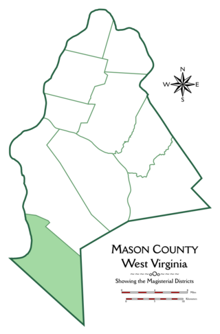
Hannan Magisterial District is one of ten magisterial districts in Mason County, West Virginia, United States. The district was originally established as a civil township in 1863, and converted into a magisterial district in 1872. In 2020, Clendenin District was home to 2,688 people.

Grant District, formerly Grant Magisterial District, is one of five historic magisterial districts in Jackson County, West Virginia, United States. The district was originally established as a civil township in 1863, and converted into a magisterial district in 1872. When Jackson County was redistricted in the 1990s, the area of Grant District was included in the new Northern Magisterial District. However, the county's historic magisterial districts continue to exist in the form of tax districts, serving all of their former administrative functions except for the election of county officials.


