Fort Hill, West Virginia

Last updated
Fort Hill, West Virginia
USA West Virginia location map.svg
Red pog.svg
Fort Hill
Location within West Virginia and the United States
Usa edcp location map.svg
Red pog.svg
Fort Hill
Fort Hill (the United States)
Coordinates: 38°21′10″N81°39′13″W / 38.35278°N 81.65361°W / 38.35278; -81.65361 Coordinates: 38°21′10″N81°39′13″W / 38.35278°N 81.65361°W / 38.35278; -81.65361
Country United States
State West Virginia
County Kanawha
Elevation
722 ft (220 m)
Time zone UTC-5 (Eastern (EST))
  Summer (DST) UTC-4 (EDT)
GNIS ID 1554493 [1]

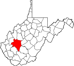
Fort Hill is an unincorporated community in Kanawha County, West Virginia, United States.

Related Research Articles

Ohio River Major river in the midwestern United States

The Ohio River is a 981-mile (1,579 km) long river in the United States. It is located in the Midwestern and Southern United States, flowing southwesterly from western Pennsylvania south of Lake Erie to its mouth on the Mississippi River at the southern tip of Illinois. It is the third largest river by discharge volume in the United States and the largest tributary by volume of the north-south flowing Mississippi River that divides the eastern from western United States. The river flows through or along the border of six states, and its drainage basin includes parts of 14 states. Through its largest tributary, the Tennessee River, the basin includes several states of the southeastern U.S. It is the source of drinking water for three million people.

Marshall County, West Virginia U.S. county in West Virginia

Marshall County is a county in the U.S. state of West Virginia. At the 2010 census, the population was 33,107. Its county seat is Moundsville. With its southern border at what would be a continuation of the Mason-Dixon line to the Ohio River, it forms the base of the Northern Panhandle of West Virginia.

Berkeley County, West Virginia U.S. county in West Virginia

Berkeley County is located in the Shenandoah Valley in the Eastern Panhandle region of West Virginia in the United States. The county is part of the Hagerstown-Martinsburg, MD-WV Metropolitan Statistical Area.

Interstate 77 (I-77) is a north–south Interstate Highway in the eastern United States. It traverses diverse terrain, from the mountainous state of West Virginia to the rolling farmlands of North Carolina and Ohio. It largely supplants the old U.S. Route 21 between Cleveland, Ohio, and Columbia, South Carolina, as an important north–south corridor through the middle Appalachians. The southern terminus of Interstate 77 is in Columbia at the junction with Interstate 26. The northern terminus is in Cleveland at the junction with Interstate 90. Other major cities that I-77 connects to include Charlotte; Charleston, West Virginia and Akron, Ohio. The East River Mountain Tunnel, connecting Virginia and West Virginia, is one of only two instances in the United States where a mountain road tunnel crosses a state line. The other is the Cumberland Gap Tunnel, connecting Tennessee and Kentucky. I-77 is a route to the southern United States for those traveling from the Great Lakes region.

Morgantown, West Virginia City in West Virginia, United States

Morgantown is the county seat of Monongalia County, West Virginia, United States, situated along the Monongahela River. West Virginia University is located in the city. The population was 29,660 at the 2010 Census Bureau, making Morgantown the largest city in North-Central West Virginia. The Morgantown metropolitan area has a population of 138,176.

Wheeling, West Virginia City in West Virginia, United States

Wheeling is a city in Ohio and Marshall counties in the U.S. state of West Virginia. Located almost entirely in Ohio County, of which it is the county seat, it lies along the Ohio River in the foothills of the Appalachian Mountains. Wheeling was originally a settlement in the British colony of Virginia, and later the second largest city in the Commonwealth of Virginia. Wheeling was where creation of West Virginia was planned, and it was the first capital of the new state. Due to its location along major transportation routes, including the Ohio River, National Road, and the B&O Railroad, Wheeling became a manufacturing center in the late nineteenth century. After experiencing the closing of factories and substantial population loss following World War II, Wheeling's major industries now include healthcare, education, law and legal services, entertainment and tourism, and energy.

Virginia Peninsula Peninsula in southeast Virginia, United States

The Virginia Peninsula is a peninsula in southeast Virginia, USA, bounded by the York River, James River, Hampton Roads and Chesapeake Bay. It is sometimes known as the Lower Peninsula to distinguish it from two other peninsulas to the north, the Middle Peninsula and the Northern Neck.

Fort Henry (West Virginia) Military base in Wheeling, West Virginia, USA

Fort Henry was a colonial fort which stood about ¼ mile from the Ohio River in what is now downtown, Wheeling, West Virginia. The fort was originally known as Fort Fincastle and was named for Viscount Fincastle, Lord Dunmore, Royal Governor of Virginia. Later it was renamed for Patrick Henry, and was at the time located in Virginia. The fort was subject to two major sieges, two notable feats and other skirmishes.

Second Battle of Winchester

The Second Battle of Winchester was fought between June 13 and June 15, 1863 in Frederick County and Winchester, Virginia as part of the Gettysburg Campaign during the American Civil War. As Confederate Lieutenant General Richard S. Ewell moved down the Shenandoah Valley in the direction of Pennsylvania, his corps defeated the Union Army garrison commanded by Major General Robert H. Milroy, capturing Winchester and numerous Union prisoners.

Fort A.P. Hill Installation of the US Army near Bowling Green, VA

Fort A.P. Hill is a training and maneuver center belonging to the United States Army located near the town of Bowling Green, Virginia. The center focuses on arms training and is used by all branches of the US Armed Forces. It is named for Virginia native and Confederate Lieutenant General A. P. Hill. Fort A.P. Hill is one of the U.S. Army installations named for Confederate soldiers to be renamed by the Commission on the Naming of Items of the Department of Defense that Commemorate the Confederate States of America or Any Person Who Served Voluntarily with the Confederate States of America.

United States National Register of Historic Places listings Register for landmarks in the United States

The National Register of Historic Places in the United States is a register including buildings, sites, structures, districts, and objects. The Register automatically includes all National Historic Landmarks as well as all historic areas administered by the U.S. National Park Service. Since its introduction in 1966, more than 90,000 separate listings have been added to the register.

Monongahela culture Archaeological culture in the US

The Monongahela culture were a Native American cultural manifestation of Late Woodland peoples from AD 1050 to 1635 in present-day western Pennsylvania, western Maryland, eastern Ohio, and West Virginia. The culture was named by Mary Butler in 1939 for the Monongahela River, whose valley contains the majority of this culture's sites.

Pricketts Fort State Park

Prickett's Fort State Park is a 188-acre (76.1 ha) West Virginia state park north of Fairmont, near the confluence of Prickett's Creek and the Monongahela River. The park features a reconstructed refuge fort and commemorates life on the Virginia frontier during the late 18th century.

Winchester, Virginia, in the American Civil War

The city of Winchester, Virginia, and the surrounding area, were the site of numerous battles during the American Civil War, as contending armies strove to control the lower Shenandoah Valley. Winchester changed hands more often than any other Confederate city.

The Huntington–Ashland metropolitan area is a metropolitan area in the Appalachian Plateau region of the United States. Referred to locally as the “Tri-State area”, the region spans seven counties in the three states of West Virginia, Kentucky, and Ohio. With a population of 361,580, the Tri-State area is nestled along the banks of the Ohio River. The region offers a diverse range of outdoor activities.

White Top West Virginia place listed on National Register of Historic Places

White Top is a knob and spur of Cheat Mountain in southeastern Randolph County, West Virginia, USA. Sitting at an elevation of 4,085 feet (1,245 m), it is located just west of the Shavers Fork of Cheat River and Cheat Bridge. While White Top was originally crossed by the Staunton-Parkersburg Turnpike, modern-day U.S. Route 250 skirts the base of the knob beside Shavers Fork to the north and east.

Interstate 70 (I-70) is a portion of the Interstate Highway System that runs from near Cove Fort, Utah, at a junction with Interstate 15 to Baltimore, Maryland. It crosses the Northern Panhandle of West Virginia through Ohio County and the city of Wheeling. This segment is the shortest of all states' through which I-70 passes, crossing West Virginia in only 14.45 miles (23.26 km). The longest segment is Colorado's, which measures 451.04 miles (725.88 km). The Fort Henry Bridge carries I-70 from Wheeling Island across the Ohio River and into downtown Wheeling before the freeway enters the Wheeling Tunnel. I-470, a southerly bypass of Wheeling and the lone auxiliary Interstate Highway in West Virginia, is intersected near Elm Grove. Before crossing into Pennsylvania, I-70 passes The Highlands, a major shopping center in the panhandle, and the Bear Rock Lakes Wildlife Management Area. On average, between 27,000 and 53,000 vehicles use the freeway every day.

References