
The Monongahela National Forest is a national forest located in the Allegheny Mountains of eastern West Virginia, USA. It protects over 921,000 acres of federally owned land within a 1,700,000 acres proclamation boundary that includes much of the Potomac Highlands Region and portions of 10 counties.

The George Washington and Jefferson National Forests are U.S. National Forests that combine to form one of the largest areas of public land in the Eastern United States. They cover 1.8 million acres (7,300 km2) of land in the Appalachian Mountains of Virginia, West Virginia, and Kentucky. Approximately 1 million acres (4,000 km2) of the forest are remote and undeveloped and 139,461 acres (564 km2) have been designated as wilderness areas, which eliminates future development.

Edwards Run Wildlife Management Area is located on 397 acres (1.6 km2) two miles (3 km) north of Capon Bridge on Cold Stream Road near Cold Stream in Hampshire County, West Virginia. Edwards Run WMA is owned by the West Virginia Division of Natural Resources.

Nathaniel Mountain Wildlife Management Area is located on 10,675 acres (43.20 km2) south of Romney in Hampshire County, West Virginia. The wildlife management area's principle access road is off Grassy Lick Road. Nathaniel Mountain is owned by the West Virginia Division of Natural Resources (WVDNR), and is one of West Virginia's largest wildlife management areas. The WMA was expanded in November 2003 after the WVDNR purchased 1,800 acres (7.3 km2) from the MeadWestvaco Corporation.

Watoga State Park is the largest of West Virginia's state parks, covering slightly over 10,100 acres (41 km2). It is located near Seebert in Pocahontas County, West Virginia.

Blackwater Falls State Park is located in the Allegheny Mountains of Tucker County, West Virginia, USA. The centerpiece of the park is Blackwater Falls, a 62-foot (19 m) cascade where the Blackwater River leaves its leisurely course in Canaan Valley and enters rugged Blackwater Canyon. It is among the most photographed venues in the state and appears on calendars, stationery, and advertisements. The river is named for its tannin-darkened water.

Moncove Lake State Park was created in 1990 by setting aside 250 acres (1.0 km2) of the Moncove Lake Wildlife Management Area to be operated as a state park. The park is located near Union in Monroe County, West Virginia. The park sits on the shores of 144-acre (0.58 km2) Moncove Lake, and underneath the flyway of the fall eastern hawk migration.
John West was acting colonial Governor of Virginia from 1635 to 1637, the third West brother to serve as governor.
Arborland Center is a shopping center located in Ann Arbor, Michigan, United States. Opened in 1961 as an unenclosed shopping mall, the center was redeveloped as a power center in 1998. Current anchor stores include Marshalls, Petco, Toy City and Bed Bath & Beyond.
The Pedlar Wildlife Management Area is located on 766 acres (310 ha) east of Blacksville in Monongalia County, West Virginia. The wildlife management area is divided into two parts centered on 5.5-acre (2.2 ha) Dixon Lake and 14.5-acre (5.9 ha) Mason Lake, named for nearby Mason–Dixon line.

Big Ditch Wildlife Management Area is a protected area located in Webster County, West Virginia near the town of Cowen. The WMA is 388 acres (157 ha) in size and is centered on Big Ditch Lake, a 55-acre (22 ha) man-made reservoir.

Seneca State Forest is a state forest located in Pocahontas County, West Virginia. Created in 1924, it is oldest state forest in West Virginia. It is the second-largest state forest at 11,684 acres (47.28 km2).

Berwind Lake Wildlife Management Area is located on 85 acres (340,000 m2) near War in McDowell County, West Virginia. The wildlife management area is centered on 20-acre (81,000 m2) Berwind Lake.

Bear Rock Lakes Wildlife Management Area is a 242-acre (98 ha) protected area located in Ohio County, West Virginia, about 8 miles (13 km) east of Wheeling. The terrain at Bear Rock Lakes is rolling hills covered by a combination of hardwood forest and open fields.

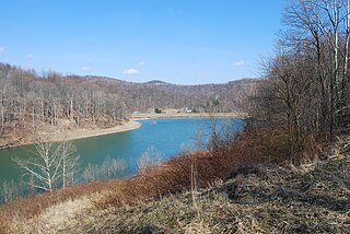
Sleepy Creek Wildlife Management Area is located in Morgan and Berkeley Counties in West Virginia's Eastern Panhandle. It encompasses 22,928 acres (92.79 km2), mostly covered with mixed oak and pine forest, although about 3,500 acres (14 km2) are covered with mixed hardwoods. The 205-acre (83 ha) Sleepy Creek Lake is located entirely within the WMA.
Oak Acres is an unincorporated community in Wood County, West Virginia.
Mineral Acres is an unincorporated community in Wood County, West Virginia.
Fairview Acres is an unincorporated community in Wood County, West Virginia.
Fairway Acres is an unincorporated community in Wood County, West Virginia, USA.


