Logan County is a county in the U.S. state of West Virginia. As of the 2020 census, the population was 32,567. Its county seat is Logan. Logan County comprises the Logan, WV Micropolitan Statistical Area, which is also included in the Charleston–Huntington–Ashland, WV–OH–KY Combined Statistical Area.

Triangular trade or triangle trade is trade between three ports or regions. Triangular trade usually evolves when a region has export commodities that are not required in the region from which its major imports come. It has been used to offset trade imbalances between different regions.
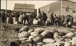
Rum-running, or bootlegging, is the illegal business of smuggling alcoholic beverages where such transportation is forbidden by law. Smuggling usually takes place to circumvent taxation or prohibition laws within a particular jurisdiction. The term rum-running is more commonly applied to smuggling over water; bootlegging is applied to smuggling over land.
Junction is an unincorporated community in Hampshire County in the U.S. state of West Virginia. Historically referred to as Moorefield Junction, Junction received its name because of its location at the crossroads of U.S. Route 220/West Virginia Route 28 and the Northwestern Turnpike. The community is located along Mill Creek.
The American Whiskey Trail is the name of a promotional program supported by the Distilled Spirits Council of the United States that promotes the distilled beverage industry in the U.S. The Trail was first promoted to the public on September 28, 2004.

Shenandoah Junction is a census-designated place (CDP) in Jefferson County in the U.S. state of West Virginia's Eastern Panhandle. As of the 2010 census, Shenandoah Junction had a population of 703. It is located between Kearneysville, WV and Charles Town, WV off WV 9. Shenandoah Junction is home to Jefferson High School and West Virginia's oldest surviving wood-frame structure, the Peter Burr House, built around 1751. The land where Shenandoah Junction was built was part of the 392 acres (1.59 km2) granted by Lord Fairfax to Lewis Neil. The town was originally called Neil's, but the name was changed to Shenandoah Junction in 1881.

The Syracuse–West Virginia football rivalry is an American college football rivalry between the Syracuse Orange football team of Syracuse University and West Virginia Mountaineers football team of West Virginia University.

Mill Creek is a 14.0-mile-long (22.5 km) tributary stream of the South Branch Potomac River, belonging to the Potomac River and Chesapeake Bay watersheds. The stream is located in Hampshire County in West Virginia's Eastern Panhandle. Mill Creek flows into the South Branch west of Romney Bridge near Vanderlip along the Northwestern Turnpike.

Argyle is an unincorporated community in Logan County, West Virginia, United States, along Rum Creek.

The Molasses Act 1733 was an Act of the Parliament of Great Britain that imposed a tax of six pence per gallon on imports of molasses from non-British colonies. Parliament created the act largely at the insistence of large plantation owners in the British West Indies. The Act was passed not to raise revenue but to regulate trade by making British products cheaper than those from the French West Indies. The Act greatly affected the significant colonial molasses trade.

The Chertsey branch line connects Virginia Water station on the Waterloo to Reading main line to Weybridge station on the Waterloo to Woking main line. It is located in Surrey, England. Chertsey is an ancient market town and was first connected by a branch line from Weybridge in 1848. The line was continued to Virginia Water in 1866. Additional spurs were provided at each end of the line, forming triangular junctions. The southern junction to Byfleet proved useful for through trains from Windsor towards Woking and Portsmouth. The line was electrified in 1937.

The current Cannock Extension Canal is a 1.8-mile (2.9 km) canal in England. It runs from Pelsall Junction on the Wyrley and Essington Canal, north to Norton Canes Docks and forms part of the Birmingham Canal Navigations. Historically, it ran to Hednesford, and served a number of collieries, which provided the main traffic. It opened in 1863, and the northern section closed in 1963, as a result of mining subsidence.

Rumer Hill Junction was a canal junction on the Cannock Extension Canal where the Churchbridge Branch left to join the Hatherton Canal. The junction, along with the northern section of the canal was abandoned in 1963. The Churchbridge Branch and Rumer Hill Junction were subsequently obliterated by opencast mining.

Rum is a liquor made by fermenting and then distilling sugarcane molasses or sugarcane juice. The distillate, a clear liquid, is often aged in barrels of oak. Rum is produced in nearly every sugar-producing region of the world, such as the Philippines, where Tanduay is the largest producer of rum globally.
Allen Junction is an unincorporated community in Wyoming County, West Virginia, United States. Their post office is still open.
Walbo is an unincorporated community in Springvale Township, Isanti County, Minnesota, United States.
West Point is an unincorporated community in Isanti County, Minnesota, United States.
Elk Run Junction is an unincorporated community in Boone County, West Virginia, United States.
Rum River is an unincorporated community in Granite Ledge Township, Benton County, Minnesota, United States. The community is located near the junction of Benton County Roads 7 and 22. Nearby places include Foley, Oak Park, and Foreston. The West Branch of the Rum River flows nearby.
West Junction is an unincorporated community in Boone County, West Virginia, United States.


