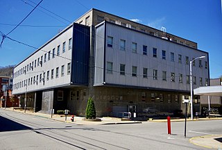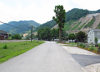
Logan County is a county in the U.S. state of West Virginia. As of the 2010 census, the population was 36,743. Its county seat is Logan. Logan County comprises the Logan, WV Micropolitan Statistical Area, which is also included in the Charleston–Huntington–Ashland, WV–OH–KY Combined Statistical Area.
U.S. Route 119 (US 119) is a spur of US 19. It is a north–south route that was an original United States highway of 1926. It is Corridor G of the Appalachian Development Highway System (ADHS) east of US 23 and KY 80 in Kentucky to Interstate 64 at Charleston, West Virginia.
West Virginia Route 972 was a short north–south state highway in Mineral County, West Virginia. It was decommissioned in July 2017, becoming an extension of WV 93. The route connected U.S. Route 220 to U.S. Route 50 in the New Creek Valley. New Creek, West Virginia, the only populated place on the route, is located midway between US 50 and US 220. Route 972 was the highest numbered road in the state of West Virginia. Prior to 1972, WV 972 was part of US 220. In 1972, US 220 was moved to its present alignment east of New Creek.
West Virginia Route 44 is a north–south state highway located within Logan County, West Virginia. The southern terminus of the route is at U.S. Route 52 one mile south of Mountain View. The northern terminus is at West Virginia Route 73 in Logan. It is marked as the Jerry West Highway after the basketball player who had jersey 44.

West Virginia Route 17 is a north-south state highway located in the southern portion of the U.S. state of West Virginia. The southern terminus of the route is at West Virginia Route 10 in Stollings a short distance east of Logan. The northern terminus is at West Virginia Route 85 in Madison.

West Virginia Route 73 is an east–west state highway located in the Logan, West Virginia area. The western terminus of the route is at an interchange with U.S. Route 119 a half-mile north of Verdunville and three miles west of Logan. The eastern terminus is at West Virginia Route 10 outside Logan.

Gip is an unincorporated community in Braxton County, West Virginia, United States. Gip's elevation is 932 feet and is in the Eastern time zone.

McConnell is an unincorporated community and census-designated place (CDP) in Logan County, West Virginia, United States, on the Guyandotte River. As of the 2010 census, its population was 514. It was established in 1933.

Lawrenceville is an unincorporated community in Hancock County, West Virginia, United States. It is located on the East Liverpool South U.S. Geological Survey Map, and lies at an elevation of 978 feet (289 m).

Stollings is an unincorporated community and census-designated place (CDP) in central Logan County, West Virginia, United States. As of the 2010 census, it had a population of 316.

Henlawson is a census-designated place (CDP) in Logan County, West Virginia, United States. Henlawson has a post office with ZIP code 25624. As of the 2010 census, its population was 442. Henlawson is believed to have been named after a resident, Henry Lawson. Merrill Coal Mines opened Merrill Mines here in 1921 and built homes to house the miners.

Davin is an unincorporated community in Logan County, West Virginia, United States. Davin is located on West Virginia Route 10 and Huff Creek, 3 miles (4.8 km) east-southeast of Man. Davin has a post office with ZIP code 25617. Davin's population is counted as part of the Mallory census-designated place.

Neibert is an unincorporated community and census-designated place (CDP) in Logan County, West Virginia, United States. Its population was 183 as of the 2010 census.

Craneco is an unincorporated community in Logan County, West Virginia, United States. Craneco is located on County Route 16 and Buffalo Creek, 8.9 miles (14.3 km) east-northeast of Man.

Becco is an unincorporated community in Logan County, West Virginia, United States. Becco is located on County Route 16 and Buffalo Creek, 4.6 miles (7.4 km) northeast of Man. Its population is included as part of the Amherstdale census-designated place.

Micco is an unincorporated community in Logan County, West Virginia, United States. Micco is located along Island Creek and West Virginia Route 44, 4.5 miles (7.2 km) south of Logan. It is included in the Switzer census-designated place.

Emmett is an unincorporated community in Logan County, West Virginia, United States. Emmett is located on Elk Creek, County Route 11/1, and the CSX Railroad, 4.8 miles (7.7 km) southeast of Man. Emmett had a post office, which closed on March 7, 1998.

Earling is an unincorporated community and census-designated place (CDP) in Logan County, West Virginia, United States. It was first listed as a CDP prior to the 2020 census. The Earling post office closed on July 1, 1989. The town now shares ZIP Code 25632 with Lyburn and Taplin.

Landville is an unincorporated community in Logan County, West Virginia, United States. Landville is located on the Guyandotte River and West Virginia Route 80, 2 miles (3.2 km) south-southeast of Man. Landville had a post office, which closed on July 9, 1988.

Gill is an unincorporated community and former railroad town in Lincoln County, West Virginia, United States.


