Talcott, West Virginia

Last updated

Talcott, West Virginia
USA West Virginia location map.svg
Red pog.svg
Talcott, West Virginia
Usa edcp location map.svg
Red pog.svg
Talcott, West Virginia
Coordinates: 37°39′05″N80°45′15″W / 37.65139°N 80.75417°W / 37.65139; -80.75417
Country United States
State West Virginia
County Summers
Elevation
1,526 ft (465 m)
Time zone UTC-5 (Eastern (EST))
  Summer (DST) UTC-4 (EDT)
ZIP code
24981
Area code(s) 304 & 681
GNIS feature ID1547876 [1]
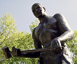
Statue of John Henry outside the town of Talcott in Summers County, WV John Henry-27527.jpg
Statue of John Henry outside the town of Talcott in Summers County, WV
The Talcott Bridge, crossing the Greenbrier heading south Talcott Bridge.png
The Talcott Bridge, crossing the Greenbrier heading south

Talcott (also Rolinsburgh or Rollinsburg) is an unincorporated community in Summers County, West Virginia, United States.

Contents

The Greenbrier River south of the Talcott Bridge Greenbrier River at Talcott, WV.jpg
The Greenbrier River south of the Talcott Bridge

It lies along West Virginia Route 3 and the Greenbrier River to the east of the city of Hinton, the county seat of Summers County. [2] Its elevation is 1,526 feet (465 m), and it is located at about 37°39′2″N80°45′4″W / 37.65056°N 80.75111°W / 37.65056; -80.75111 (37.6506762, -80.7511921). [3] It has a post office with the ZIP code 24981. [4]

History

Talcott is named for Capt. Talcott, a civil engineer with the Chesapeake and Ohio Railway who was in charge of building the Big Bend Tunnel. [5] [6]

4th of July Parade along Rt. 3 in Talcott, WV. 4th July Talcott, WV.jpg
4th of July Parade along Rt. 3 in Talcott, WV.

John Henry legend

Talcott has gained some fame for being what many in the area consider to be the home of the John Henry legend. Henry was an African-American railroad worker in the 1800s who supposedly competed in a legendary race with a steam-powered drill bit, and won, dying in the process. Historian Louis Chappell traveled to Talcott in the 1920s and interviewed railroad workers who claimed to have worked with Henry when building the Great Bend tunnel on the C&O line through Talcott. The accounts of the surviving workers seemed to corroborate that Henry was, in fact, a real person, although the other aspects to the legend were impossible to confirm or deny based on the interviews conducted by Chappell [7]

The Hilldale-Talcott Ruritan Club raised a statue of Henry atop Big Bend mountain in 1972 to commemorate the legend. The statue now stands outside of the Great Bend Tunnel, in John Henry Park. [8] Talcott now hosts an annual John Henry Days festival each July that features re-tellings of the famous legend, duck races, craft booths, and other festivities. [9]

Recreation and activities

Talcott lies along the lower Greenbrier River. As a river community, activities revolve around fishing, boating, and canoeing. A public boat ramp is located next to the Talcott Bridge, and this is a popular starting point for float trips down the Greenbrier to Hinton, WV. [10] Fishing camps and summer houses line the river in the area.

Related Research Articles

<span class="mw-page-title-main">Summers County, West Virginia</span> County in West Virginia, United States

Summers County is a county located in the U.S. state of West Virginia. As of the 2020 census, the population was 11,959. Its county seat is Hinton. The county was created by an act of the West Virginia Legislature on February 27, 1871, from parts of Fayette, Greenbrier, Mercer and Monroe counties and named in honor of George W. Summers (1804–68).

<span class="mw-page-title-main">John Henry (folklore)</span> Folklore character

John Henry is an American folk hero. An African American freedman, he is said to have worked as a "steel-driving man"—a man tasked with hammering a steel drill into a rock to make holes for explosives to blast the rock in constructing a railroad tunnel.

<span class="mw-page-title-main">Greenbrier River</span> River in West Virginia, United States

The Greenbrier River is a tributary of the New River, 162 miles (261 km) long, in southeastern West Virginia, in the United States. Via the New, Kanawha and Ohio rivers, it is part of the watershed of the Mississippi River, draining an area of 1,656 square miles (4,290 km2). It is one of the longest rivers in West Virginia.

<span class="mw-page-title-main">West Virginia Route 12</span> State highway in West Virginia, United States

West Virginia Route 12 is a north–south route located in the southern portion of the U.S. state of West Virginia. The southern terminus of the route is at U.S. Route 219 in Peterstown, Monroe County, less than 300 yards (270 m) from the Virginia state line. It compromises a portion of the Farm Heritage Road byway between Peterstown and West Virginia Route 122. The northern terminus of the route is at U.S. Route 60 in Alta, Greenbrier County, near Interstate 64 exit 161.

<span class="mw-page-title-main">Brooks, West Virginia</span> Unincorporated community in West Virginia, United States

Brooks is an unincorporated community in Summers County, West Virginia, United States. It lies along the New River to the north of the city of Hinton, the county seat of Summers County. Its elevation is 1,657 feet.

Elton is an unincorporated community in Summers County, West Virginia, United States. It lies to the northeast of the city of Hinton, the county seat of Summers County. Its elevation is 1,749 feet. Elton had a post office, with the ZIP code of 25965, until it closed on July 11, 2009.

<span class="mw-page-title-main">Forest Hill, West Virginia</span> Unincorporated community in West Virginia, United States

Forest Hill is an unincorporated community in Summers County, West Virginia, United States. It lies along West Virginia Route 12 to the southeast of the city of Hinton, the county seat of Summers County. Its elevation is 1,926 feet. It has a post office with the ZIP code 24935.

Green Sulphur Springs is an unincorporated community in Summers County, West Virginia, United States. It lies near Interstate 64 to the northeast of the city of Hinton, the county seat of Summers County. Its elevation is 1,552 feet. Green Sulphur Springs had a post office, with the ZIP code 25966, until it closed on February 29, 1992.

<span class="mw-page-title-main">Nimitz, West Virginia</span> Unincorporated community in West Virginia, United States

Nimitz is an unincorporated community in Summers County, West Virginia, United States. It lies along West Virginia Route 3 to the west of the city of Hinton, the county seat of Summers County. Its elevation is 2,523 feet. It has a post office with the ZIP code 25978.

Pipestem is an unincorporated community in Summers County, West Virginia, United States. It lies along West Virginia Route 20 to the south-southwest of the city of Hinton, the county seat of Summers County. Its elevation is 2,382 feet. It has a post office with the ZIP code 25979. It has a population of 764 people.

<span class="mw-page-title-main">Sandstone, West Virginia</span> Unincorporated community in West Virginia, United States

Sandstone is an unincorporated community in Summers County, West Virginia, United States. It lies along West Virginia Route 20 and the New River to the north of the city of Hinton, the county seat of Summers County. Its elevation is 1,352 feet. It has a post office, with the ZIP code of 25985.

<span class="mw-page-title-main">Pence Springs, West Virginia</span> Unincorporated community in West Virginia, United States

Pence Springs is an unincorporated community in Summers County, West Virginia, United States. It lies along the Greenbrier River to the east of the city of Hinton, the county seat of Summers County. Its elevation is 1,539 feet, and it is located at 37°40′41″N80°43′30″W. It had a post office with the ZIP code 24962 until it was closed in October 2011.

Smoot is an unincorporated community in western Greenbrier County, West Virginia, United States. It lies south of the interchange of Interstate 64 and U.S. Route 60, northwest of the city of Lewisburg, the county seat of Greenbrier County. Its elevation is 2,480 feet (756 m). It has a post office with the ZIP code 24977.

Ranger is an unincorporated community in western Lincoln County, West Virginia, United States. It lies along West Virginia Route 10 southwest of the town of Hamlin, the county seat of Lincoln County. Its elevation is 614 feet (187 m). It has a post office with the ZIP code 25557. Ranger is served by the Guyan River VFD.

Creston is an unincorporated community in southeastern Wirt County, West Virginia, United States. It lies at the confluence of the Little Kanawha River and the West Fork Little Kanawha River on West Virginia Route 5, southeast of the town of Elizabeth, the county seat of Wirt County. Its elevation is 653 feet (199 m). Creston had a post office, which closed on June 25, 2011. The community was named for a drainage divide near the town site.

Proctor is an unincorporated community in northwestern Wetzel County, West Virginia, United States. It lies on West Virginia Route 2 along the Ohio River, north of the city of New Martinsville, the county seat of Wetzel County. Its elevation is 630 feet (192 m). Because the community has borne multiple names, the Board on Geographic Names officially designated it "Proctor" in 1980. It has a post office with the ZIP code 26055.

Fort Spring is an unincorporated community and town in Greenbrier County, West Virginia, United States. It is situated along the Greenbrier River within the Greenbrier River Watershed. It was once a substantial portion of the Chesapeake and Ohio railway by way of the Gravel Girtie route from Hinton in Summers County to Clifton Forge, Virginia. The name is derived from its main export; Mississippian limestone from Snowflake Quarry sent to Clifton Forge. The main road going through the small town was once the original rail line, but was moved.

Clayton is an unincorporated community in Summers County, West Virginia, United States. The community was first settled in 1813. Clayton once had a post office, which opened in 1879 and closed in 1959.

Bargers Springs is an unincorporated community in Summers County, West Virginia, United States. It has also been called ″Greenbriar Springs″. Bargers Springs is located on the Greenbrier River, southeast of Hinton.

Lowell is an unincorporated community in Summers County, West Virginia, United States. Lowell is located on the Greenbrier River, east of Hinton and southwest of Alderson. The community was first settled in 1770 and is the oldest community in Summers County.

References

  1. "US Board on Geographic Names". United States Geological Survey. October 25, 2007. Retrieved January 31, 2008.
  2. Rand McNally. The Road Atlas '04. Chicago: Rand McNally, 2004, p. 112.
  3. Geographic Names Information System Feature Detail Report, Geographic Names Information System, 1980-06-27. Accessed 2008-01-18.
  4. USPS – Cities by ZIP Code
  5. Miller, James Henry (1908). History of Summers County from the Earliest Settlement to the Present Time. J.H. Miller. pp.  356.
  6. Kenny, Hamill (1945). West Virginia Place Names: Their Origin and Meaning, Including the Nomenclature of the Streams and Mountains. Piedmont, WV: The Place Name Press. p. 619.
  7. "Talcott prepares for John Henry Days".
  8. "John Henry Park, Talcott, WV".
  9. "Talcott prepares for John Henry Days".
  10. "Boat Launches on Greenbrier River".