Grafton is a city in — and the county seat of — Taylor County, West Virginia, United States. The population was 5,164 at the 2010 census. Both of West Virginia's national cemeteries are located in Grafton. Mother's Day was founded in Grafton on May 10, 1908 and the city is home to the International Mother's Day Shrine.

The Tygart Valley River — also known as the Tygart River — is a principal tributary of the Monongahela River, approximately 135 miles (217 km) long, in east-central West Virginia in the United States. Via the Monongahela and Ohio rivers, it is part of the watershed of the Mississippi River, draining an area of 1,329 square miles (3,440 km2) in the Allegheny Mountains and the unglaciated portion of the Allegheny Plateau.

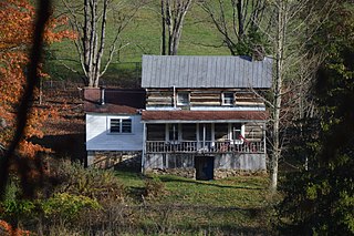
Simpson is an unincorporated community in Taylor County, West Virginia. It is the hometown of Randal McCloy, sole survivor of the 2006 Sago Mine disaster at Sago in Upshur County.
East Dailey is a census-designated place (CDP) in Randolph County, West Virginia, United States. As of the 2010 census, its population was 557. It is located within the Monongahela National Forest adjacent to the Tygart Valley River. East Dailey and its Old Timer's Camp are host to the Elkhenge Music Festival.
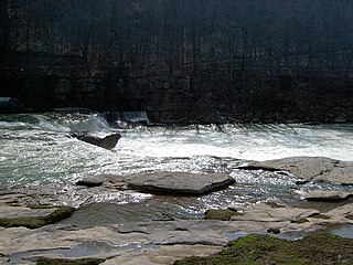
Valley Falls State Park is a 1,145 acre (4.63 km²) day use facility sited along both banks of the Tygart Valley River. The park is located about 7 miles (11 km) south of exit 137 of I-79, near Fairmont, West Virginia.
Tygart Lake State Park sits on 391 acres (1.58 km2) along the shores of Tygart Lake in Taylor County near Grafton, West Virginia, United States.

Pleasant Creek Wildlife Management Area is located near Philippi, West Virginia in Barbour and Taylor counties. Located on 3,030 acres (1,230 ha) land that varies from wetlands to steeply forested woodlands, the Pleasant Creek WMA rises to an elevation of 1,600 feet (490 m).

Pruntytown State Farm Wildlife Management Area, is located near Pruntytown, West Virginia in Taylor County. The WMA is managed as a beef cattle farm by the West Virginia Department of Agriculture. Located on 1,764 acres (7.14 km2) gently sloping farmland with hay and pasture fields and woodlots on the steeper slopes.
Dailey is a census-designated place (CDP) in Randolph County, West Virginia, United States. Dailey is located on U.S. Route 219 and U.S. Route 250 3 miles (4.8 km) south-southwest of Beverly. Dailey has a post office with ZIP code 26259. As of the 2010 census, its population was 114.
Rockport is an unincorporated community in Wood County, West Virginia, United States. It lies at an elevation of 705 feet (215 m), along Tygart Creek. It is the last exit in Southern Wood County along I-77 and is unincorporated, with the ZIP code of 26169.
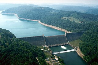
Tygart Dam — also known as Tygart River Dam — is a federally built and operated dam in Taylor County, West Virginia, United States. The dam regulates the waters of the Tygart Valley River. Its storage reservoir is known as Tygart Lake. Most of the lakeshore is occupied by Tygart Lake State Park and Pleasant Creek Wildlife Management Area. The structure was listed on the National Register of Historic Places in 1995.
Cecil — originally Cecil Station — is an unincorporated community in Taylor County, West Virginia, USA.
Stone House — or Stonehouse — is a former unincorporated community in Taylor County, West Virginia, USA. The site is now underwater in Tygart Lake, having been inundated after construction of the Tygart Dam (1934-38).
Yates is a former unincorporated community in Taylor County, West Virginia. The site is now underwater in Tygart Lake, having been inundated after construction of the Tygart Dam (1934-38).
Tygart Junction is an unincorporated community in Barbour County, West Virginia, United States.

Fox Forest Wildlife Management Area (WMA) is located south of Elkins, West Virginia in Randolph County. It is located along the Tygart Valley River and is adjacent to the West Virginia Division of Natural Resources' Elkins Operations Center.
The North Western Virginia Railroad was chartered as Northwestern Virginia on February 14, 1851. It built track from Grafton, West Virginia to Parkersburg, West Virginia. It opened on November 1, 1857. Mileage: 103 to 104 depending on edition of Poor's; in 1883-1884 Poor's including Ohio River bridge 105.4 miles Contracts dated July 18, 1864 according to Poor's Manual of Railroads indicate the Baltimore and Ohio Railroad bought out the interest of Baltimore City Northwestern Virginia bonds.