Grafton is a city in — and the county seat of — Taylor County, West Virginia, United States. The population was 5,164 at the 2010 census. Both of West Virginia's national cemeteries are located in Grafton. Mother's Day was founded in Grafton on May 10, 1908 and the city is home to the International Mother's Day Shrine.

The Monongahela River — often referred to locally as the Mon — is a 130-mile-long (210 km) river on the Allegheny Plateau in north-central West Virginia and southwestern Pennsylvania, which flows from south to north. The Monongahela joins the Allegheny River to form the Ohio River at Pittsburgh.

The Tygart Valley River — also known as the Tygart River — is a principal tributary of the Monongahela River, approximately 135 miles (217 km) long, in east-central West Virginia in the United States. Via the Monongahela and Ohio rivers, it is part of the watershed of the Mississippi River, draining an area of 1,329 square miles (3,440 km2) in the Allegheny Mountains and the unglaciated portion of the Allegheny Plateau.

East Dailey is a census-designated place (CDP) in Randolph County, West Virginia, United States. As of the 2010 census, its population was 557. It is located within the Monongahela National Forest adjacent to the Tygart Valley River. East Dailey and its Old Timer's Camp are host to the Elkhenge Music Festival.
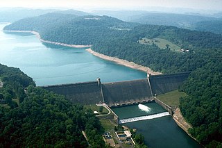
Tygart Lake State Park sits on 391 acres (1.58 km2) along the shores of Tygart Lake in Taylor County near Grafton, West Virginia, United States.

Pleasant Creek Wildlife Management Area is located near Philippi, West Virginia in Barbour and Taylor counties. Located on 3,030 acres (1,230 ha) land that varies from wetlands to steeply forested woodlands, the Pleasant Creek WMA rises to an elevation of 1,600 feet (490 m).
Tygarts Valley Middle/High School is a public secondary school in Mill Creek, West Virginia. Established in 1923, the school serves students in grades 6 through 12.
Dailey is a census-designated place (CDP) in Randolph County, West Virginia, United States. Dailey is located on U.S. Route 219 and U.S. Route 250 3 miles (4.8 km) south-southwest of Beverly. Dailey has a post office with ZIP code 26259. As of the 2010 census, its population was 114.
Rockport is an unincorporated community in Wood County, West Virginia, United States. It lies at an elevation of 705 feet (215 m), along Tygart Creek. It is the last exit in Southern Wood County along I-77 and is unincorporated, with the ZIP code of 26169.
Tygarts Valley Church, also known as Tygarts Valley Presbyterian Church, is a historic Presbyterian church on U.S. Routes 219/250 in Huttonsville, Randolph County, West Virginia. It was built in 1883, and is a Victorian-Gothic style building. The church measures 61 by 31 feet and features a 105-foot-tall (32 m) spire.
Tygart Dam — also known as Tygart River Dam — is a federally built and operated dam in Taylor County, West Virginia, United States. The dam regulates the waters of the Tygart Valley River. Its storage reservoir is known as Tygart Lake. Most of the lakeshore is occupied by Tygart Lake State Park and Pleasant Creek Wildlife Management Area. The structure was listed on the National Register of Historic Places in 1995.
Leading Creek is a tributary of the Tygart Valley River, 17.4 miles (28.0 km) long, in eastern West Virginia in the United States. Via the Tygart Valley, Monongahela and Ohio rivers, it is part of the watershed of the Mississippi River, draining an area of 61 square miles (160 km2) in the Allegheny Mountains. The stream's entire course and drainage basin are in northern Randolph County.
Elkwater is an unincorporated community in Randolph County, West Virginia, United States. Elkwater is located on U.S. Route 219 and West Virginia Route 55 along the Tygart Valley River, 5.6 miles (9.0 km) south-southwest of Huttonsville.
Hazelwood is an unincorporated community in Randolph County, West Virginia, United States. Hazelwood is located along the Tygart Valley River on U.S. Route 219, U.S. Route 250, West Virginia Route 55, and West Virginia Route 92 4.5 miles (7.2 km) south of Elkins.
Upper Mingo is an unincorporated community in southern Randolph County, West Virginia, United States. Upper Mingon is located along the Tygart Valley River on U.S. Route 219 and West Virginia Route 55, 17 miles (27 km) south-southwest of Mill Creek.
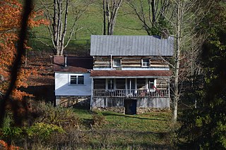
Stone House — or Stonehouse — is a former unincorporated community in Taylor County, West Virginia, USA. The site is now underwater in Tygart Lake, having been inundated after construction of the Tygart Dam (1934-38).
Sandy is a former unincorporated community in Taylor County, West Virginia, USA. The site is now underwater in Tygart Lake, having been inundated after construction of the Tygart Dam (1934-38).
Tygart Junction is an unincorporated community in Barbour County, West Virginia, United States.

Fox Forest Wildlife Management Area (WMA) is located south of Elkins, West Virginia in Randolph County. It is located along the Tygart Valley River and is adjacent to the West Virginia Division of Natural Resources' Elkins Operations Center.