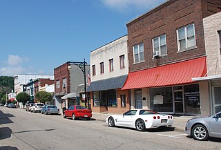
Covington is an independent city in the Commonwealth of Virginia. As of the 2020 census, the population was 5,737, making it the second-least populous city in Virginia. It is surrounded by Alleghany County, of which it is also the county seat. Located at the confluence of Jackson River and Dunlap Creek, Covington is one of three cities in the Roanoke Regional Partnership. The Bureau of Economic Analysis combines the city of Covington with Alleghany county for statistical purposes.

Clifton Forge is a town in Alleghany County, Virginia, United States which is part of the greater Roanoke Region. The population was 3,555 at the 2020 census. The Jackson River flows through the town, which as a result was once known as Jackson's River Station.

Alleghany County is an American county located on the far western edge of Commonwealth of Virginia. It is bordered by the Allegheny Mountains, from which the county derives its name, and it is the northernmost part of the Roanoke Region. The county seat is Covington. As of the 2020 census, the population was 15,223.
Rock Cave is an unincorporated community in Upshur County, West Virginia, United States. The town is located southwest of Buckhannon at the junction of West Virginia Route 4 with County Routes 11/2 and 20/28.
Forge Hill is an unincorporated community in Mineral County, West Virginia, United States. It is part of the Cumberland, MD-WV Metropolitan Statistical Area. Forge Hill lies to the northeast of the City of Keyser on a hill of the same name, overlooking the North Branch Potomac River.

Jefferson Rock is a rock formation on the Appalachian Trail in Harpers Ferry, West Virginia. It consists of several large masses of Harpers shale, piled one upon the other, that overlook the Shenandoah River just prior to its confluence with the Potomac River. It was added to the National Register of Historic Places as a contributing property of the Harpers Ferry National Historical Park on October 15, 1966.
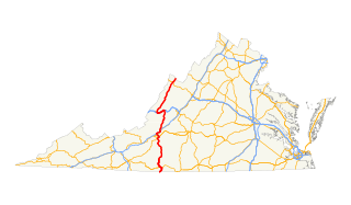
In the U.S. state of Virginia, U.S. Route 220 (US 220) is a major north-south state highway that extends from the North Carolina state line through Roanoke to the West Virginia state line. South of Roanoke, US 220 is a four-lane highway within the proposed Interstate 73 (I-73) corridor. US 220 narrows to two lanes north of Roanoke, connecting to I-64 near Clifton Forge and then paralleling the Appalachian Mountains north-northeasterly in the direction of Cumberland, Maryland.
The Huntington–Ashland metropolitan area is a metropolitan area in the Appalachian Plateau region of the United States. Referred to locally as the “Tri-State area”, and colloquially as "Kyova", the region spans seven counties in the three states of West Virginia, Kentucky, and Ohio. With a population of 361,580, the Tri-State area is nestled along the banks of the Ohio River. The region offers a diverse range of outdoor activities.
Rock Castle is an unincorporated community in southwestern Jackson County, West Virginia, United States. It lies along Rock Castle Road, south of the city of Ripley, the county seat of Jackson County. Its elevation is 705 feet (215 m).
Fort Spring is an unincorporated community and town in Greenbrier County, West Virginia, United States. It is situated along the Greenbrier River within the Greenbrier River Watershed. It was once a substantial portion of the Chesapeake and Ohio railway by way of the Gravel Girtie route from Hinton in Summers County to Clifton Forge, Virginia. The name is derived from its main export; Mississippian limestone from Snowflake Quarry sent to Clifton Forge. The main road going through the small town was once the original rail line, but was moved.
Rock View is an unincorporated community in Wyoming County, West Virginia, United States.
Rock is an unincorporated community in Mercer County, West Virginia, United States. Rock is located along West Virginia Route 71, 2 miles (3.2 km) northeast of Montcalm. Rock has a post office with ZIP code 24747.
Falling Rock is an unincorporated community in Kanawha County, West Virginia, United States. Falling Rock is located at the confluence of Falling Rock Creek with the Elk River 3 miles (4.8 km) southwest of Clendenin along US Route 19. Falling Rock has a post office with ZIP code 25079.
Weir is an unincorporated community in Kanawha County, West Virginia, United States. Its post office is called Falling Rock.
Black Rock is a summit in Mineral County, West Virginia, in the United States. With an elevation of 3,159 feet (963 m), Black Rock is the 296th highest summit in the state of West Virginia.

Barbours Creek Wilderness is a U.S. wilderness area in the Eastern Divide Ranger District of George Washington and Jefferson National Forests of western Virginia, United States. The wilderness area was established in 1988 and consists of 5,382 acres (2,178 ha) of forests in the Appalachian Mountains ranging in elevation from 1,700 to 3,800 feet.
The Covington Papermakers were a minor league baseball team based in Covington, Virginia in 1914. The Covington Papermakers played as charter members of the short–lived Class D level Virginia Mountain League, winning the league championship in a shortened season. The Papermakers were succeeded in Covington minor league baseball by the 1966 Covington Red Sox.


