
Monongalia County, known locally as Mon County, is located in the U.S. state of West Virginia. As of the 2020 census, the population was 105,822, making it West Virginia's third-most populous county. Its county seat is at Morgantown. The county was founded in 1776. Monongalia County is included in the Morgantown, WV Metropolitan Statistical Area, and is the largest county in North-Central West Virginia. It is part of the Pittsburgh media market.
Kings Park is a hamlet and census-designated place (CDP) in the Town of Smithtown, in Suffolk County, on Long Island, in New York, United States. The population was 17,282 as of the 2010 census.

Islip is a town in Suffolk County, New York, United States, on the south shore of Long Island. The population was 335,543 at the 2010 census, making it the fourth most populous city or town in the state.
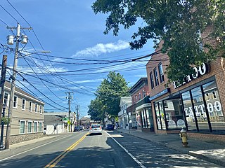
Smithtown is a hamlet and census-designated place (CDP) within the Town of Smithtown in Suffolk County, New York. The population was 26,470 at the 2010 census. The hamlet includes the former Village of The Landing, which was dissolved in 1939.

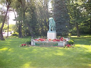
Smithtown is a town in Suffolk County, New York, on the North Shore of Long Island. It is part of the New York metropolitan area. The population was 116,296 at the 2020 Census.

New York State Route 25A (NY 25A) is a state highway on Long Island in New York, United States. It serves as the main east–west route for most of the North Shore of Long Island, running for 73 miles (117 km) from Interstate 495 (I-495) at the Queens–Midtown Tunnel in the New York City borough of Queens to NY 25 in Calverton, Suffolk County. The highway is a northern alternate route of NY 25, which follows a more inland routing along Jericho Turnpike.
Caleb Smith State Park Preserve is a state park located in Suffolk County, New York in the United States. The park is near the north shore of Long Island in the town of Smithtown. Prior to its current name, the park was called Nissequogue River State Park, a name now used for park lands on the former Kings Park Psychiatric Center grounds. Previously, it was simply known as the Wyandanch Preserve.

New York's 1st congressional district is a congressional district for the United States House of Representatives in eastern Long Island. It includes the eastern two-thirds of Suffolk County, including the northern portion of Brookhaven, as well as the entirety of the towns of Huntington, Smithtown, Riverhead, Southold, Southampton, East Hampton, and Shelter Island. The district encompasses extremely wealthy enclaves such as the Hamptons, middle class suburban towns such as Selden, Centereach and Lake Grove, working-class towns such as Riverhead and rural farming communities such as Mattituck and Jamesport on the North Fork. The district currently is represented by Republican Nick LaLota.

New York State Route 347 (NY 347) is an east–west state highway located in Suffolk County, New York, in the United States. It connects the Northern State Parkway in Hauppauge to NY 25A in Mount Sinai. The route serves as a southern bypass of Smithtown and as a direct link between Nesconset and Port Jefferson. Along the way, NY 347 intersects NY 25 in Nesconset and Nicolls Road in Lake Grove. The westernmost 2 miles (3.2 km) of NY 347 is concurrent with NY 454 while the portion northeast of NY 25 parallels NY 25A, which follows a more northerly alignment through the town of Brookhaven than NY 347.
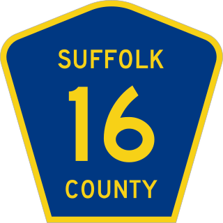
County Route 16 (CR 16) is a main thoroughfare through central Suffolk County, New York, in the United States. Its western terminus is at Middle Country Road in Village of the Branch, and its eastern terminus is at Montauk Highway (CR 80) in Brookhaven. The route carries five different names along its length: Terry Road, Smithtown Boulevard, Lake Shore Road, Portion Road, and Horseblock Road.
Smithtown is a station on the Port Jefferson Branch of the Long Island Rail Road. It is located off a low bridge over NY 25 – 25A along Redwood Lane between NY 25-25A and Landing Avenue in Smithtown, New York.

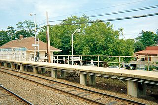
St. James is a historic station on the Port Jefferson Branch of the Long Island Rail Road. The station is located on Lake Avenue and Railroad Avenue, just south of New York State Route 25A in St. James, Suffolk County, New York.
Smithtown is an unincorporated community and census-designated place (CDP) in northern Yadkin County, North Carolina, United States. It was first listed as a CDP in the 2020 census with a population of 224.
Smithtown Central School District is a school district in New York which serves residents in the Smithtown communities of Smithtown, Nesconset, Kings Park, and Saint James. Parts of neighboring Smithtown communities Ronkonkoma, Lake Ronkonkoma, Hauppauge, and Stony Brook are also served. The Smithtown Central School District is the home of the Smithtown and Saint James LIRR stations. Covering an area of 35 square miles (91 km2), SCSD serves approximately 10,000 students in eight elementary schools, three 6-8 middle schools, and two high schools. It is the largest school district on Long Island.
Dickinson, also known as Quincy, is an unincorporated community in Kanawha County, West Virginia, United States. Dickinson is located on the north bank of the Kanawha River, 3 miles (4.8 km) southeast of Belle. The community is served by U.S. Route 60.

Sharon Methodist Episcopal Church is located in Sharon Township, a rural area of northwest Clinton County, Iowa, United States. The building is the only remaining structure that remains of a community by the name of Burgess, which was nicknamed Smithtown. The building is commonly referred to as the Smithtown Church. It was listed on the National Register of Historic Places in 2003.

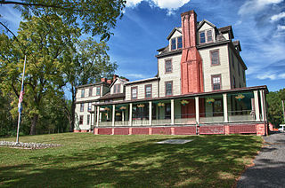
Old Watson Homestead House, also known as Rowe Residence, is a historic home located at Smithtown, Monongalia County, West Virginia. It is a two-story, "L"-shaped Federal style brick dwelling with Italianate details. The original house was built about 1803, with two additions, one completed about 1843 and another in the late 1850s. It is one of Monongalia County's oldest and most significant homes.
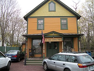
The Saint James General Store is a general store located on the northwest corner of Moriches and Harbor Hill Roads in Saint James, New York. Established in 1857, it is a contributing property of the Saint James District, which is primarily in the vicinity of New York State Route 25A in St. James, although the store is located northwest of Route 25A.


