
The Monongahela National Forest is a national forest located in the Allegheny Mountains of eastern West Virginia, USA. It protects over 921,000 acres of federally managed land within a 1,700,000 acres proclamation boundary that includes much of the Potomac Highlands Region and portions of 10 counties.

The Rapidan River, flowing 88 miles (142 km) through north-central Virginia in the United States, is the largest tributary of the Rappahannock River. The two rivers converge just west of the city of Fredericksburg. The Rapidan River begins west of Doubletop Mountain in Shenandoah National Park where the Mill Prong meets the Laurel Prong at Rapidan Camp, approximately 3 miles (4.8 km) south of Big Meadows. The river defines the border of Orange County with Culpeper and Madison Counties.
Laurel Dale is an unincorporated community on New Creek in Mineral County, West Virginia, United States. Laurel Dale was established in 1878. The community is located along West Virginia Route 93.
Forbes State Forest is a Pennsylvania state forest in Pennsylvania Bureau of Forestry District #4. The main offices are located in Laughlintown in Westmoreland County, Pennsylvania in the United States. Mount Davis, the highest peak in Pennsylvania, is located in the forest.
Laurel Mountain may refer to:
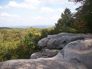
Laurel Mountain, also called Laurel Hill, is a long ridge in north-central West Virginia, US. Along with Rich Mountain to the south, it is considered to be the westernmost ridge of the Allegheny Mountains and the boundary between the Alleghenies and the Allegheny Plateau.

Laurel Fork is a 37.8-mile-long (60.8 km) river in eastern West Virginia, USA. It is a tributary of the Dry Fork; via the Dry Fork, the Black Fork, and the Cheat, Monongahela and Ohio rivers, it is part of the watershed of the Mississippi River, draining an area of 60 square miles (160 km2) in the Allegheny Mountains. With the Dry Fork, the Glady Fork, the Shavers Fork and the Blackwater River, it is considered to be one of the five principal headwaters tributaries of the Cheat River.
Laurel Fork may refer to:
Ararat is an unincorporated community in Patrick County, Virginia, United States, south of the Blue Ridge Parkway and north of Mount Airy, North Carolina. Ararat is located near the Virginia–North Carolina state line about five miles (8.0 km) north of Mount Airy and about 25 miles (40 km) west of Stuart, Virginia. The community's name comes from the Ararat River which flows through the area. The River takes its name from the Jefferson Fry Map of 1751, which calls Pilot Mountain part of the "Mountains of Ararat." The Saura Indian name for nearby Pilot Mountain in Surry County, North Carolina is "The Pilot" and the mountain reverted to that. The large monadnock mountain was thought to resemble a bullfrog and the Native Americans named it "Ratratrat," after the sound the animal makes. Early white settlers thought what they were saying sounded like "Ararat," the mountain which, according to the Bible, was the landing point of Noah's Ark.

Laurel Fork South Wilderness is a U.S. Wilderness Area located in the Greenbrier Ranger District of Monongahela National Forest in West Virginia. The Wilderness protects high-elevation lands along Laurel Fork and is bordered by Middle Mountain to the west. It is a companion to Laurel Fork North Wilderness, the two being split by Randolph County Route 40. Laurel Fork South contains 9 miles (14 km) of hiking trails.

Laurel Fork North Wilderness is a U.S. Wilderness Area located in the Greenbrier Ranger District of Monongahela National Forest in West Virginia. The Wilderness protects high-elevation lands along Laurel Fork and is bordered by Middle Mountain to the west. It is a companion to Laurel Fork South Wilderness, the two being split by Randolph County Route 40. Laurel Fork North contains 9.5 miles (15.3 km) of hiking trails.

Laurel Lake Wildlife Management Area is located between Dingess and Lenore in Mingo County, West Virginia. Located on 12,856 acres (5,203 ha) of steep terrain with narrow valleys and ridgetops, the WMA contains second growth mixed hardwoods and hemlock with thick understory of mountain laurel and rhododendron.

Virginia State Route 102 and West Virginia Route 102 are adjoining state highways in the U.S. states of Virginia and West Virginia. The two state highways together run 11.4 miles (18.3 km) from Center Street in Pocahontas, Virginia east to the Virginia – West Virginia state line between the twin cities of Bluefield, Virginia and Bluefield, West Virginia. Most of Route 102 consists of three sections in Virginia maintained by the Virginia Department of Transportation (VDOT); the two intervening sections in West Virginia are maintained by the West Virginia Division of Highways. In addition to connecting Pocahontas with the two Bluefields, the state highway passes through Nemours, West Virginia and Falls Mills, Virginia and provides access to Bluefield College.

Chestnut Ridge is the westernmost ridge of the Allegheny Mountains in Pennsylvania, United States. It is located primarily within the Laurel Highlands region of southwestern Pennsylvania, extending into northern West Virginia.
Laurel Creek is an unincorporated community and coal town in Fayette County, West Virginia, United States.

The Laurel Fork is a 15.7-mile-long (25.3 km) stream in Virginia and West Virginia, United States. The stream flows north from Highland County, Virginia, where its source and the majority of its length is located, to its mouth in Pendleton County, West Virginia. Laurel Fork is a tributary to the North Fork South Branch Potomac River, making it a part of the Potomac River watershed. The area surrounding Laurel Fork is home to several plant and animal species found nowhere else in Virginia, and is a prime example of a northern boreal forest in the state.
The North Carolina–Tennessee–Virginia Corners is a tripoint at which North Carolina, Tennessee and Virginia meet. The landmark is located in the Iron Mountains, and is roughly 16 miles north of Snake Mountain, and 8 miles southwest of Mount Rogers.

Washington District, formerly Washington Magisterial District, is one of five historic magisterial districts in Jackson County, West Virginia, United States. The district was originally established as one of five civil townships in Jackson County after West Virginia became a state in 1863; in 1872, all of West Virginia's townships were converted into magisterial districts. When Jackson County was redistricted in the 1990s, Washington District was combined with the eastern portion of Ripley District, including the city of Ripley, to form the new Eastern Magisterial District. However, the county's historic magisterial districts continue to exist in the form of tax districts, serving all of their former administrative functions except for the election of county officials.


