Osage, West Virginia

Last updated

Osage
"MINER'S MEMORIAL POOL - "Rear Admiral Joel T. Boone with group of miner's children at swimming pool which was constructed by popular... - NARA - 540301 (cropped).jpg
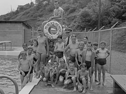
Pool in Osage in 1946 with swimmers and Rear Admiral Joel T. Boone
USA West Virginia location map.svg
Red pog.svg
Osage
Location within the state of West Virginia
Usa edcp location map.svg
Red pog.svg
Osage
Osage (the United States)
Coordinates: 39°39′31″N80°00′27″W / 39.65861°N 80.00750°W / 39.65861; -80.00750
Country Flag of the United States.svg  United States
State Flag of West Virginia.svg  West Virginia
County Flag of Monongalia County, West Virginia.svg Monongalia
Elevation
[1]
873 ft (266 m)
Time zone UTC-5 (Eastern (EST))
  Summer (DST) UTC-4 (EDT)
GNIS feature ID1544449 [1]

Osage is an unincorporated community in Monongalia County, West Virginia, United States. It lies across the Monongahela River from Morgantown.

The community was named after the Osage Indians. [2]

Related Research Articles

<span class="mw-page-title-main">Montgomery County, Kansas</span> County in Kansas, United States

Montgomery County is a county located in Southeast Kansas. Its county seat is Independence, and its most populous city is Coffeyville. As of the 2020 census, the county population was 31,486. The county was named after Richard Montgomery, a major general during the American Revolutionary War.

<span class="mw-page-title-main">Osage County, Oklahoma</span> County in Oklahoma, United States

Osage County is the largest county by area in the U.S. state of Oklahoma. Created in 1907 when Oklahoma was admitted as a state, the county is named for and is home to the federally recognized Osage Nation. The county is coextensive with the Osage Nation Reservation, established by treaty in the 19th century when the Osage relocated there from Kansas. The county seat is in Pawhuska, one of the first three towns established in the county. The total population of the county as of 2020 was 45,818.

<span class="mw-page-title-main">Osage County, Missouri</span> County in Missouri, United States

Osage County is a county in the central part of the U.S. state of Missouri. As of the 2020 census, the population was 13,274. Its county seat is Linn. The county was organized January 29, 1841, and named from the Osage River.

<span class="mw-page-title-main">Miller County, Missouri</span> County in Missouri, United States

Miller County is a county located in the U.S. state of Missouri. As of the 2020 United States census, the population was 24,722. Its county seat is Tuscumbia. The county was organized February 6, 1837 and named for John Miller, former U.S. Representative and Governor of Missouri.

<span class="mw-page-title-main">Osage County, Kansas</span> County in Kansas, United States

Osage County is a county located in the U.S. state of Kansas. Its county seat is Lyndon, and its most populous city is Osage City. As of the 2020 census, the county population was 15,766. The county was originally organized in 1855 as Weller County, then renamed in 1859 after the Osage tribe.

<span class="mw-page-title-main">Pawhuska, Oklahoma</span> City in Oklahoma, United States

Pawhuska is a city in and the county seat of Osage County, Oklahoma, United States. It was named after the 19th-century Osage chief, Paw-Hiu-Skah, which means "White Hair" in English. The Osage tribal government, which opened offices in Pawhuska in 1872 when its reservation was established in Indian Territory, continues to be based in Pawhuska.

The Osage Nation, a Native American tribe in the United States, is the source of most other terms containing the word "osage".

<span class="mw-page-title-main">Osage Nation</span> Native American Siouan-speaking tribe in the United States

The Osage Nation is a Midwestern Native American tribe of the Great Plains. The tribe developed in the Ohio and Mississippi river valleys around 700 BC along with other groups of its language family. They migrated west after the 17th century, settling near the confluence of the Missouri and Mississippi rivers, as a result of Iroquois invading the Ohio Valley in a search for new hunting grounds.

Berryman is an unincorporated community on the border between Crawford and Washington counties in the U.S. state of Missouri. Located along Route 8, it lies in the Mark Twain National Forest, approximately sixteen miles west of Potosi. Courtois Creek flows under Route 8, just west of the village. Berryman Recreation Area and trail lie to the northeast of the village.

<span class="mw-page-title-main">Bonnots Mill, Missouri</span> Unincorporated community in Missouri, United States

Bonnots Mill is an unincorporated community in northern Osage County, Missouri, United States. It is located approximately ten miles east of Jefferson City on the Osage River, near its confluence with the Missouri River. The community of Osage City is about four miles to the west-southwest on the Osage and the community of Tebbetts lies across the Missouri River valley to the north. It has also been known as Dauphine, Bonnets Mills, Bonnots, or Bonnotts Mill.

<span class="mw-page-title-main">Rural Municipality of Fillmore No. 96</span> Rural Municipality in Saskatchewan, Canada

The Rural Municipality of Fillmore No. 96 is a rural municipality (RM) in the Canadian province of Saskatchewan within Census Division No. 2 and SARM Division No. 1. It is located in the south-east portion of the province along Highway 33.

Highway 33 is a highway in the southern portion of the Canadian province of Saskatchewan connecting Regina to Stoughton; the highway is divided near Regina. Highway 33 is about 139 km (86 mi) long.

Osage Mills is an unincorporated community in Benton County, Arkansas, United States. The millsite and associated dam is located on Little Osage Creek about eight miles southwest of Rogers. It is the location of the following places listed on the National Register of Historic Places on January 28, 1988:

Hoecker is an unincorporated community in northeast Miller County, in the U.S. state of Missouri. The community is on a meander of the Osage River just south of the Miller-Cole county line. Henley is two miles to the west-northwest in Cole County and Meta is six miles to the east in Osage County.

Capps is an unincorporated community in northern Miller County, in the U.S. state of Missouri.

Castle Rock is an extinct town in Osage County, in the U.S. state of Missouri. The townsite lies is located on the inside curve of an incised meander of the Osage River. The Castle Rock formation for which it was named lies across the river to the north in Cole County just southeast of Wardsville. The Pikes Camp Wildlife Area lies to the west across the river.

Potts is an unincorporated community in Osage County, in the U.S. state of Missouri. Potts is located on U.S. Route 50 between Linn to the west and Mount Sterling to the east, in Gasconade County.

Femme Osage Creek is a stream in St. Charles County in the U.S. state of Missouri. It is a tributary of the Missouri River.

Pershing is an unincorporated community and census-designated place (CDP) in Osage County, Oklahoma, United States. It was first listed as a CDP prior to the 2020 census.

Whippoorwill is an unincorporated community and census-designated place (CDP) in Osage County, Oklahoma, United States. It was first listed as a CDP prior to the 2020 census.

References

  1. 1 2 U.S. Geological Survey Geographic Names Information System: Osage, West Virginia
  2. Kenny, Hamill (1945). West Virginia Place Names: Their Origin and Meaning, Including the Nomenclature of the Streams and Mountains. Piedmont, WV: The Place Name Press. p. 462.